

Website Spotlight
| Welcome to Weather Underground! Sign In or Create an Account. Edit my Page Preferences. | Other Wunders: Mobile - iPhone - Lite - Desktop |
Dr. Jeff Masters' WunderBlog |
 |
Last Updated: 2:40 PM GMT on September 18, 2008
— Last Comment: 3:29 PM GMT on September 18, 2008
Well, it's now day four of my promised 7-10 day lull in Atlantic
hurricane activity. That prediction still looks reasonable. Heavy
thunderstorm activity has begun to increase over the Lesser Antilles
Islands, where a tropical wave is interacting with an upper-level low
pressure system. This tropical wave is moving westwards at about 15
mph, and has an impressive surge of moisture with it, as seen on animations of total precipitable water
from the University of Wisconsin CIMSS group. The region is under about
10-20 knots of wind shear, and probably won't be able to organize much
today or Friday due to the shear and presence of the upper-level low
pressure system. By Saturday, wind shear is expected to drop over the
entire Caribbean, and the upper level wind flow becomes more
anticyclonic. These are favorable conditions for tropical cyclone
development, and we may have something develop by Sunday in the central
or western Caribbean. The NOGAPS is the only major model predicting
something will develop. However, most of the models are forecasting the
development of a tropical depression off the coast of Africa early next
week. I expect we will have Tropical Storm Kyle, either in the
Caribbean or off the coast of Africa, by the middle of next week.
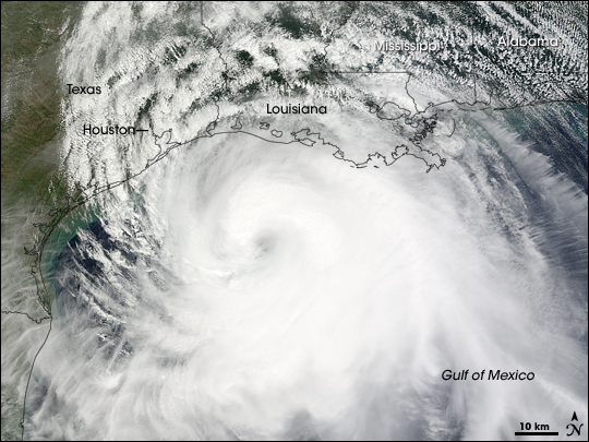 Figure 1. Hurricane Ike at 12:05 pm CDT September 12, 2008, as seen by NASA's Terra satellite. Image creidt: NASA Earth Observatory. Why did Ike get so large? Hurricane Ike grew unusually large, eventually filling up the entire Gulf of Mexico and becoming larger than Katrina. How did it get so big? Well, one theory is that the storm's passage over Cuba helped it to grow in size. During the day and half the eye of Ike traversed Cuba, the thunderstorm activity near the center was suppressed by land. However, a large portion of the storm was over the exceptionally warm waters of the Loop Current on either side of Cuba. Since the storm couldn't put any energy into intensifying and maintaining its core, the energy pulled out of the Loop Current went into expanding and intensifying the outer portions of the storm that were over water. When Ike finally emerged into the Gulf of Mexico, its scale had been reset to this new larger size, and the storm was able to maintain the new scale. A similar transition to a new larger scale also occurred to Hurricanes Katrina and Andrew after they passed over South Florida. How you can help The group of wunderground members that are spearheading their own Hurricane Ike relief effort, aimed at providing assistance and supplies to people that are not in the mainstream relief areas, have now raised $7700. The first relief truck with supplies is on the way to Texas. Deductions are tax-deductible, and can be made in several ways: Patrap's wunderblog www.stormjunkie.com www.portlight.org Of course, contributing to the Red Cross or your local church is another great way to help out. Thanks! Jeff Masters
We're in day three of my promised 7-10 day lull in Atlantic hurricane
activity. That prediction is still looking good. There are no threat
areas to discuss today, and the earliest any model foresees a tropical
storm developing is Sunday, when the NOGAPS indicates something
developing in the western Caribbean. The GFS model predicts this
development will occur on the other side of Central America, in the
Eastern Pacific. The GFS also predicts development of a tropical
depression by Tuesday off the coast of Africa.
The destruction of Gilchrist Many of you have probably seen the photo of Gilchrist, Texas showing complete destruction of the town of 750 people, save for one lone home. High-resolution satellite imagery made available by NOAA's National Geodetic Survey (Figure 1) confirm that of the approximately 1000 structures existing in the town before Hurricane Ike, only about five survived the hurricane. Approximately 200 of these buildings were homes, and it is thought that some of the residents attempted to ride out the storm in their homes. According to media reports, about 34 survivors from Gilchrist and the neighboring communities of Crystal Beach and Port Bolivar have been fished out of Galveston Bay in the past few days. Rescuers who have reached Gilchrist have not been able to find any victims in the debris because there is no debris. Ike's storm surge knocked 99.5% of the 1,000 buildings in Gilchrist off their foundations and either demolished them or washed them miles inland into the swamplands behind Gilchrist. Until search teams can locate the debris of what was once was Gilchrist, we will not know the fate of those who may have stayed behind to ride out the storm. 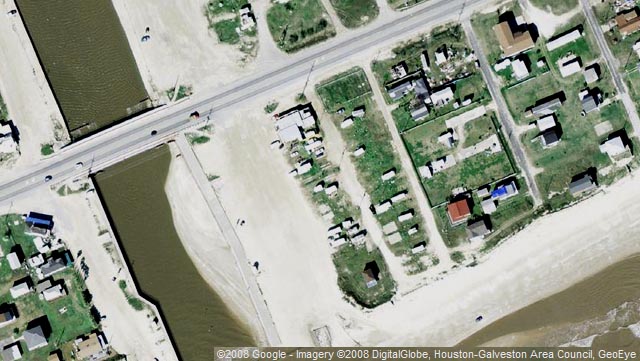 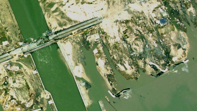 Figure 1. The town of Gilchrist, Texas before and after Hurricane Ike. Image credit (top): Googlemaps.com, DigitalGlobe, GeoEye, Houston-Galveston Area Council. Bottom: National Geodetic Survey. Why did Gilchrist get destroyed? It's rare to see a town so completely destroyed by a hurricane, to the point where you can't even see the wreckage. The neighboring towns of Crystal Beach, to the south, and High Island, to the north, were also mostly destroyed, but weren't swept clean of nearly all structures and wreckage. This is because Gilchrist was built in an unusually vulnerable place. It's bad enough to situate your town on a low-lying peninsula, as was the case for Crystal Beach. But in Gilchrist's case, the town was located at the narrowest point of the Bolivar Peninsula, at a point where it was only a few hundred meters wide (Figure 2). Not only did Gilchrist suffer a head-on assault by Ike's direct storm surge of 14+ feet, topped by 20' high battering waves, the town also suffered a reverse surge once the hurricane had passed. As Ike moved to the north, the counter-clockwise flow of wind around the storm pushed Galveston Bay's waters back across the town of Gilchrist from northwest to southeast. This second surge of water likely finished off anything the main storm surge had left. Will Gilchrist be rebuilt? I hope the government will see fit to buy up the land that was once the town of Gilchrist and make it into a park. Building a town in Gilchrist's location makes as much sense as building a town on the sides of an active volcano. (Unfortunately, there are plenty of people who have done just that, such as on the slopes of Mt. Vesuvius in Italy). If past history is any guide, Gilchrist will be rebuilt, and it will take another mighty hurricane to permanently take down the town. That was the case for the town of Indianola, Texas, which lay in a vulnerable low-lying location on the shores of Matagorda Bay in the mid-1800's. Indianola was the second largest port in the state of Texas, and home to 5,000 people. In 1875, a powerful Category 3 hurricane piled up a huge storm surge as it came ashore in Indianola. The surge destroyed 3/4 of the town's 2,000 buildings, and killed 176 people. The city was rebuilt, but in 1886, a devastating Category 4 hurricane swept almost the entire town of Indianola into Matagorda Bay, killing another 250 townspeople. The people of Indianola finally gave up and moved elsewhere, and the ruins of their town now lie under four feet of water in Matagorda Bay. 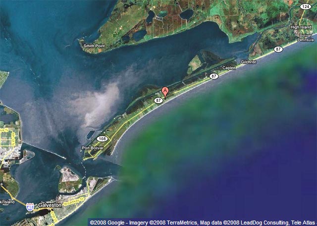 Figure 2. The Bolivar Peninsula, Texas before Hurricane Ike. The "A" pink balloon marker shows the location of Crystal Beach. Gilchrist is to the northeast of Crystal Beach, at a point where the peninsula narrows down to just a few hundred meters wide. Image credit: Googlemaps.com, TerraMetrica, LeadDog Consulting, Tele Atlas. Links to follow High-resolution photos of the Bolivar Peninsula are available using Microsoft's HD View Beta. How you can help For those of you who want to help those in need, I'm proud to say that a group of wunderground members are spearheading their own Hurricane Ike relief effort, aimed at providing assistance and supplies to people that are not in the mainstream relief areas. They've already raised $5000, and the first relief truck with supplies is on the way to Texas. Deductions are tax-deductible, and can be made in several ways: Patrap's wunderblog www.stormjunkie.com www.portlight.org Everything they are doing is at the specific request of people on the scene. At the request of the Director of Disability Affairs for the Mayor of Houston, they are sending 50 wheelchairs, 500 walkers, 200 pairs of crutches, and several pallets of first aid supplies. They are also sending a 16-foot truck from Charleston loaded with drinks, personal hygiene products, and non perishable food items. A truck is heading out of New Orleans with similar supplies. Every Catholic school in South Carolina is collecting supplies with the goal of filling two more trucks. Of course, contributing to the Red Cross or your local church is another great way to help out. Thanks! Jeff Masters
If you take a ferry from Galveston northeast across the Galveston Bay
inlet, you arrive at the small town of Port Bolivar, which sits at the
end of the 25 mile-long Bolivar Peninsula. Since the peninsula was
situated on the right front side of Ike's eye, it took the worst of the
storm. The Hurricane Hunters measured 110 mph winds at the shore when
Ike made landfall, and Ike's highest storm surge hit the peninsula. The
exact height of the storm surge is unknown, since there were no tide
gauges there. Based on reports of a storm surge of 11 feet at Galveston
Island and 13.5 feet at the Louisiana/Texas border, it is likely that
storm surge heights along the Bolivar Peninsula were 14 feet or higher.
Photos taken by the U.S. Geological Survey
yesterday (Figure 1) of the Bolivar Peninsula show the tremendous
damage a huge storm surge can do--entire neighborhoods of homes washed
off their foundations and completely destroyed. Had Ike not wobbled 50
miles to the right in the hours prior to landfall, the scenes below
could have been what Galveston would have looked like, even with their
seawall.
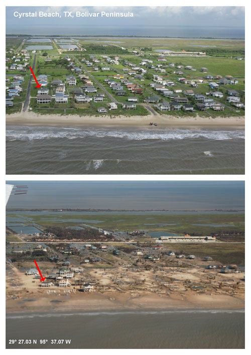 Figure 1. Oblique aerial photography of Bolivar Peninsula, TX, from September 9, 2008 (top) and September 15, 2008, two days after landfall of Hurricane Ike. Image credit: U.S. Geological Survey. Their web site will be posting more comparison photos in coming days as they do more flights. Dr. Abby Sallenger, Jr. of the USGS described yesterday's damage survey flight: Here's what we saw in our overflight from about Grand Chenier in western Louisiana to Freeport below Galveston. We saw vast areas flooded by storm surge; the water extended landward in places for tens of kilometers. The beaches served as rims that contained the flood waters. In Louisiana, channels were cut (naturally) through the beaches so the water would drain seaward. Where the max surge occurred (between Bolivar Peninsula and Sabine Pass), the returning water completely submerged the Gulf shore for kilometers. The maximum impacts were on the Bolivar Peninsula, the site of our example comparisons online now. How you can help For those of you who want to help those in need, I'm proud to say that a group of wunderground members are spearheading their own Hurricane Ike relief effort, aimed at providing assistance and supplies to people that are not in the mainstream relief areas. Deductions are tax-deductible, and can be made in several ways: Patrap's wunderblog www.stormjunkie.com www.portlight.org Of course, contributing to the Red Cross or your local church is another great way to help out. Thanks! The tropics are quiet The tropics are quiet. The area of disturbed weather (92L) approaching the Lesser Antilles Islands that we were watching has been torn apart by wind shear. There are no threat areas to discuss at this time. The ECMWF and NOGAPS models indicate the possibility of something developing in about six days in the Western Caribbean near Mexico's Yucatan Peninsula. The GFS model predicts development of a tropical depression off the coast of Africa about six days from now. Atlantic hurricane outlook for the last half of September Well, we've just come out of a long and intense period of hurricane activity--29 straight days with a named storm in the Atlantic, with all four of these storms--Fay, Gustav, Hanna, and Ike--causing heavy damage and inflicting high death tolls. The last time we had such an active period was in 2005, when we went 56 straight days from August 2 to September 26 with a named storm in the Atlantic. Katrina, Ophelia, and Rita all made landfall during that period. Fortunately, even the busiest hurricane seasons take a breather. We had a 4-day break in 2005 at the end of September. This year, we look to get a longer break of 7-10 days. Climatologically, the last half of September is one of the busiest periods in the Atlantic for hurricane activity. The peak of the season occurs on September 10, and the entire month of September is very active, with a high chance of dangerous major hurricanes (Figure 2). Sea Surface temperatures and oceanic heat content are at their peak right now, and have not begun to cool yet. Wind shear is near average or a little below average over most of the tropical Atlantic, and is forecast to remain so for the next two weeks. The peak portion of hurricane season lasts until mid-October, and I anticipate that we have at least one more major hurricane coming, and probably 4-5 more named storms. 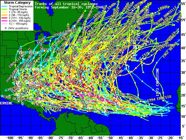 Figure 2. Tracks of all hurricane and tropical storms for the past 156 years that formed in the last half of September. In the longer term, winds shear is predicted by NOAA's CFS model to remain below average over the Caribbean for all of October and November. The model also predicts that Sea Surface Temperatures (SSTs) will range from 1-2°C above average over most of the hurricane main development region (from the coast of Africa to Central America between 10° and 20° latitude, including the Caribbean). SSTs have cooled dramatically in the Gulf of Mexico and Bahamas, thanks to the passage of Fay, Gustav, Hanna, and Ike stirring up cold waters. These reduced SSTs will reduce the possibility of a major hurricane hitting the U.S. and Bahamas during the remainder of hurricane season. However, SSTs are about 1°C above average over the Caribbean and the region between Africa and the Lesser Antilles Islands. That's a lot of fuel for potential hurricanes during the coming months. 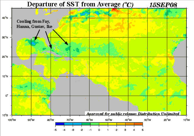 Figure 3. Departure of Sea Surface Temperature (SST) from average for September 15, 2008. Note the strong cooling of up to 4°C in the Gulf of Mexico created by Hurricanes Gustav and Ike when they churned up cool waters from the depths. Image credit: U.S. Navy. When will activity pick up again? There is an oscillation in the atmosphere I haven't talked about much before, called the Madden-Julian Oscillation (MJO) that will influence when hurricane season will get more active. The MJO is a pattern of enhanced rainfall that travels along the Equator, and can act to boost hurricane activity when it propagates into the Atlantic. The MJO has a period of about 30-60 days, and is currently in its inactive phase over the Atlantic. However, according to the latest MJO discussion from the National Weather Service's Climate Prediction Center, we are expected to enter an active phase for the MJO over the western Gulf of Mexico and Caribbean beginning six days from now. As I mentioned above, the ECMWF and NOGAPS models are indicating the possibility of development in this region beginning about Monday of next week. So, enjoy the quiet interlude this week, because I expect by late next week there will be one new named storm in the Atlantic. The steering current pattern is not expected to change in the coming two weeks, and will favor steering hurricanes into the East Coast of the U.S. or Gulf of Mexico. By the beginning of October, I expect more recurving hurricane to occur, as the jet stream begins its annual Fall migration southward. Jeff Masters
Ike caused plenty of trouble Sunday over the Midwest. High winds near
Cincinnati killed one person and caused about 1.3 million people to
lose power in southern Ohio and northern Kentucky. A Delta Airlines
hangar at the Cincinnati airport lost its roof, and the airport control
tower had to be evacuated. Flooding and high winds in Missouri and
Illinois caused at least two storm-related deaths.
Ike surprised Louisville, Kentucky, with sustained winds of 40 mph with
a gust to hurricane force, 75 mph, at 1:56 pm CDT. Ike swept into
western New York early this morning, knocking out power to 45,000
people and doing about $100 million in damage.
Part of the destruction wrought in the Midwest and Northeast was also due to the remnants of Eastern Pacific Tropical Storm Lowell. Lowell hit Mexico's Baja Peninsula earlier in the week, and the moisture from the storm flowed northeastward up the axis of a cold front sweeping across the U.S. This same cold front also absorbed Ike. Some peak wind gusts observed yesterday from Ike: Louisville, KY 75 MPH Covington, KY 74 MPH Huntingburg, IN 67 MPH Fort Knox, KY 64 MPH Owensboro, KY 63 MPH Walnut Ridge, AR 62 MPH Popular Bluff, MO 61 MPH Cincinnati/Lunkin, OH 61 MPH Some peak storm rainfall totals for various states, as of 10 PM CDT on Sunday: Houston, TX: 15.75" Glenmore, LA: 7.62" Clinto, AR: 8.93" Maize, KS: 11.44: Fairview, KS: 11.83" Oakland Mills, IA: 7.60" Peotone, IL: 10.40" Portage, IN: 11.46" South Haven, MI: 6.68" Mill Creek, OH: 7.08" Murrysville, PA: 5.41" Genoa City, WI: 3.25" Falls City, NE: 3.39" 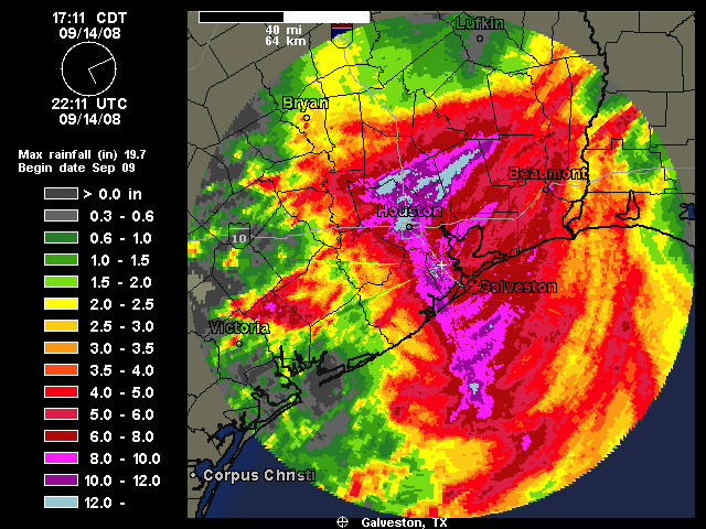 Figure 1. Total radar-estimated precipitation from Ike. Chicago gets hammered by Lowell's remnants O'Hare airport in Chicago broke its 20-year old 24-hour rainfall record Saturday, when 6.81" fell. The heavy rain triggered the worst flooding on record for the Des Plaines River in Chicago's western suburbs. The heavy rain was due to a cold front that was packed with moisture from the remnants of Tropical Storm Lowell. Ike's damage In its wake, Ike has left a Texas-sized disaster. AIR Worldwide, Inc, is estimating that total insured damage in Texas and Louisiana will be $10 billion. An additional $1 billion in damage was likely done in the Gulf of Mexico, due to wind and wave damage to oil platforms and the indirect loss of revenue attributable to reductions in oil and gas production. Using the usual rule of thumb that total hurricane damages are double the insured damages, the price tag for Ike will be about $22 billion. That would make Ike the third costliest hurricane in history. Only Hurricane Katrina of 2005 and Hurricane Andrew of 1992 did more damage than Ike has. AIR has not yet factored in the damage done to the Midwest on Sunday. Other risk-modeling insurance firms are estimating the total on-shore insured property damage will range between $6 billion and $18 billion. These estimates place Ike somewhere between the sixth and second most destructive hurricane on record. The media is focusing primarily on two main areas in this massive disaster--the destruction in Galveston, and the plight of millions living in Houston and its suburbs. I'd like to call attention to two hard-hit areas mostly ignored by the media--the Bolivar Peninsula just northeast of Galveston, and coastal Louisiana. The Bolivar Peninsula If you take a ferry from Galveston northeast across the Galveston Bay inlet, you arrive at the small town of Port Bolivar, which sits at the end of the 25 mile-long Bolivar Peninsula. Since the peninsula was situated on the right front side of Ike's eye, it took the worst of the storm. The Hurricane Hunters measured 110 mph winds at the shore when Ike made landfall, and Ike's highest storm surge hit the peninsula. The exact height of the storm surge is unknown, since there were no tide gauges there. Based on reports of a storm surge of 11 feet at Galveston Island and 13.5 feet at the Louisiana/Texas border, it is likely that storm surge heights along the Bolivar Peninsula were 15 feet or higher. Photos taken by the Coast Guard yesterday (Figure 2) of the Bolivar Peninsula show damage characteristic of a 15+ foot high storm surge--homes washed off their foundations and completely destroyed. The hurricane probably cut new channels through the peninsula, and it will be difficult for rescuers to reach the area. 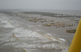 Figure 2. Coast Guard photo of the Bolivar Peninsula after Hurricane Ike. All the houses along this section were washed off their foundations by the storm surge and destroyed. Image credit: bolivar.org. Some have criticized the National Weather Service for overwarning, with their pronouncement of "certain death" for those who ignored evacuation orders. Well, I don't think anyone in the Bolivar Peninsula will complain that they were overwarned. While death was not certain among those who weathered the storm in houses pulverized by the storm surge, it was probable. According to the New York Times, one Bolivar Peninsula resident was washed all the way across across Galveston Bay to the mainland after the storm surge destroyed his house and threw him into the water. A helicopter picked him up. So far, there are three confirmed deaths on the peninsula, from the town of Port Bolivar. The peninsula had a population of 3,800, of which 500 did not evacuate. As many as 90 people were rescued from the peninsula in the hours leading up to the storm, but at least 400 people remained. Most of these people are as yet unaccounted for. According to news reports, 80% of the buildings on the peninsula were destroyed. The moral: we don't know precisely where a hurricane will hit, which necessitates dire warnings for portions of the coast that will not receive the worst of the storm. The worst of a hurricane affects only a relatively narrow portion of the coast. And the worst of Hurricane Ike--the third most damaging hurricane of all time--was very, very bad indeed. Louisiana Hurricane Ike hit Louisiana very hard. The entire coast of Louisiana from Grand Isle at the mouth of the Mississippi River to the Texas border received a storm surge between 5 and 13 feet. In many cases, such as in Lake Charles, the flood heights were higher than those of Hurricane Rita in 2005. Terrebonne Parish in central Louisiana, which took a direct hit from Gustav but did not get flooded by that storm, got a 5-8 foot storm surge from Ike. The surge flooded over 13,000 homes and killed at least two people in the parish. The tropics are quiet Today, for the first time since August 15, we do not have a named storm in the Atlantic. The remains of Josephine are completely gone, so we will not have a seventh consecutive named storm hit the U.S. The landfall of Ike on Saturday set a new record, giving us strikes by six consecutive named storms. Five was the previous record, set most recently in 2004. An area of disturbed weather (92L), 600 miled east of the northernmost Lesser Antilles Islands, has changed little in the past 24 hours. This disturbance is under about 25 knots of wind shear, and is suffering from dry air to its west. NHC is giving this system a low (<20% chance) of developing into a tropical depression by Wednesday. Wind shear is expected to remain high, above 20 knots, for the next three days. By Thursday, if 92L finds itself farther south than expected--near the Bahama Islands--shear may drop enough to allow development to occur. We should keep an eye on this one, if it does stay to the south. Elsewhere, the GFS model is forecasting development of a tropical depression off the coast of Africa seven days from now. I'll discuss the long-term outlook for the coming two weeks in a blog entry on Tuesday. Jeff Masters
The National Hurricane Center has issued its last advisory on Tropical Depression Ike,
which is now accelerating northeastward through Illinois. Ike is
causing only modest trouble, dumping 2-5 inches of rain along its path
and triggering scattered severe thunderstorms. Ike has generated just
five tornadoes so far. Two small tornadoes affected Arkansas yesterday,
and three were reported in Louisiana on Friday. The Storm Prediction
Center has placed portions of Michigan, Indiana, and Ohio at slight risk today of receiving tornadoes as Ike speeds by.
Ike's damage In it's wake, Ike has left a Texas-sized disaster. AIR Worldwide, Inc, is estimating that total insured damage in Texas and Louisiana will be $10 billion. An additional $3.4 billion in damage was likely done in the Gulf of Mexico, due to wind and wave damage to oil platforms and the indirect loss of revenue attributable to reductions in oil and gas production. Using the usual rule of thumb that total hurricane damages are double the insured damages, the price tag for Ike will be about $27 billion. That would make Ike the third costliest hurricane in history. Only Hurricane Katrina of 2005 and Hurricane Andrew of 1992 did more damage than Ike has. So far, the death toll from Ike has been remarkably low, considering the level of damage this storm inflicted. Let's hope it stays this way.  Figure 1. Hurricane Ike approaching Galveston Island, as seen by Synthetic Aperture Radar (SAR). The white dot in the eye is the freighter Antalina, which got caught in the storm when its engines failed. A tugboat towed the Antilina safely to port on Saturday, and all 22 crewmen are well and the ship is undamaged. They'll have quite a story to tell (bet they barfed plenty)! Image Copyright ESA [2008], captured and processed by CSTARS University of Miami under license from Eurimage. CSTARS runs jointly with the Canadian Space Agency and the European Space Agency a Hurricane Watch program where they take routine SAR images of tropical storms during hurricane season. The tropics are quiet On Monday, for the first time since August 15, we will not have a named storm in the Atlantic. The area of disturbed weather (91L) near the Bahamas that we were watching has been done in by dry air and wind shear. There is another area of disturbed weather (92L) midway between Africa and the Lesser Antilles Islands we are watching. This disturbance is under about 25 knots of wind shear, and is suffering from dry air to its west. NHC is giving this system a low (<20% chance) of developing into a tropical depression by Tuesday. Wind shear is now expected to remain high, above 20 knots, for the next five days, and I don't see much chance of this system developing. None of the computer models are forecasting development of any tropical storms in the coming week. We have hit a much-appreciated lull in this season's activity, but we're probably not all done yet. I'll discuss the long-term outlook for the coming two weeks in a blog entry on Tuesday. My next post will be Monday morning. Jeff Masters
Hurricane Ike
made a direct hit on Galveston, Texas this morning at 3 am EDT as a
top-end Category 2 hurricane with 110 mph winds. Although only rated a
Category 2 storm, Ike carried a storm surge characteristic of a
Category 4 hurricane to shore. The destructive power of Ike's storm
surge rated a 5.0 on a scale of 0 to 6 just before landfall, according
to the experimental Integrated Kinetic Energy (IKE) product of NOAA's Hurricane Research Division. This is about the same destructive potential Katrina had at landfall.
 Figure 1. Radar image of Ike shortly after landfall. The eye passed directly over Galveston, and along the east side of Houston. Galveston is not destroyed Although Ike caused heavy damage by flooding Galveston with a 12-foot storm surge, the city escaped destruction thanks to its 15.6-foot sea wall (the wall was built 17 feet high, but has since subsided about 2 feet). The surge was able to flow into Galveston Bay and flood the city from behind, but the wall prevented a head-on battering by the surge from the ocean side. Galveston was fortunate that Ike hit the city head-on, rather than just to the south. Ike's highest storm surge occurred about 50 miles to the northeast of Galveston, over a lightly-populated stretch of coast. Galveston was also lucky that Ike did not have another 12-24 hours over water. In the 12 hours prior to landfall, Ike's central pressure dropped 6 mb, and the storm began to rapidly organize and form a new eyewall. If Ike had had another 12-24 hours to complete this process, it would have been a Category 4 hurricane with 135-145 mph winds that likely would have destroyed Galveston. The GFDL model was consistently advertising this possibility, and it wasn't far off the mark. It was not clear to me until late last night that Ike would not destroy Galveston and kill thousands of people. Other hurricane scientists I conversed with yesterday were of the same opinion.  Figure 2. Radar images of Ike on Friday, 9/12/08. In the left image, we see Ike as it appeared Friday afternoon, with no eyewall and relatively weak echoes. The pressure of the storm was 958 mb. By Friday night (right panel), Ike had begun to form an eyewall, and the echoes had become much more intense. Ike had a pressure of 952 mb at this time. Ike's winds Houston Hobby Airport on the south side of town recorded winds of 75 mph, gusting to 92 mph, at 6 am CDT today. The winds likely were higher, but the anemometer failed. The airport measured a central pressure of 960 mb as the eye passed just to the east. Houston Intercontinental Airport on the north side of town recorded top winds of 56 mph, gusting to 70 mph. Eagle Point on Galveston Bay, at the northern end of Texas City, recorded sustained winds of 68 mph, gusting to 87 mph, at 1:34 am CDT. Top winds measured at Galveston Pleasure Pier were 60 mph, and the station recorded a pressure of 952 mb as the eye of Ike passed over. Top winds at Sabine Pass on the Louisiana border were a sustained 70 mph. Much higher winds undoubtedly occurred on Galveston Island and nearby coastal areas, but the anemometers failed before these winds were recorded. An experimental wind analysis done by NOAA's Hurricane Research Division suggests that Category 2 force winds probably only affected a 40-mile stretch of coast northeast of Galveston. There were no weather stations there to record these peak winds. Category 2 winds undoubtedly occurred at the tops of Houston's skyscrapers, as well. 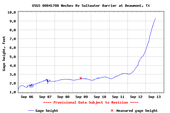 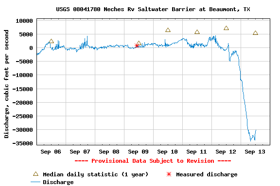 Figure 3.water levels on the Neches River in Beaumont, TX (top) on the Louisiana border increased by 6 feet as Ike's surge progressed upriver. The river has reversed its direction of flow, as seen in the negative river discharge numbers (bottom). Winds peaked at 60 mph at this location. Image credit: U.S. Geological Survey. Ike's storm surge Tide gauge data suggests that a storm surge of 12-14 feet affected the region from Galveston to the Louisiana border. Higher storm surges in excess of 15-20 feet likely occurred in Galveston Bay and northeastward, as inferred by comparing the observed surge values we have with the 11 pm forecast surge values (Figure 4). At 10am this morning, the National Weather Service was reporting water levels of 12 feet in the Houston Ship Channel, and 10-14 feet in Galveston Bay. In Port Arthur, TX, on the Louisiana border, the surge reached 11 feet, and did not overtop their 14.5 foot high sea wall, sparing the city and its oil refineries from the major flooding that was feared. 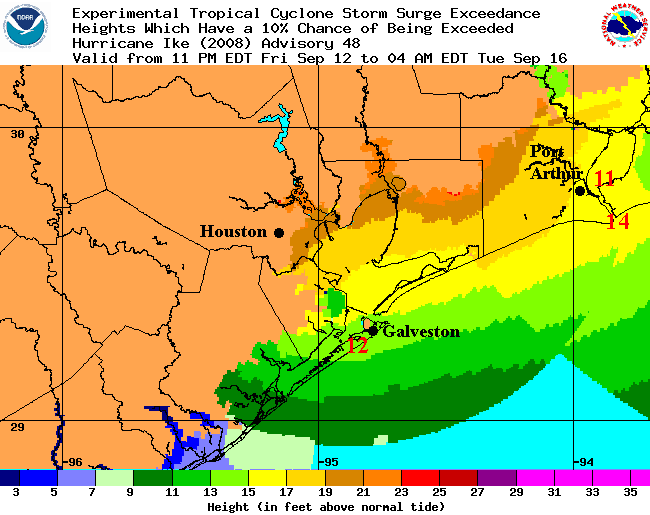 Figure 4. Predicted storm surge from Ike issued shortly before the hurricane came ashore. There was a 10% chance given that the actual surge would excede the forecast heights shown here. The actual storm tide heights (surge plus the tide, shown as red numbers) show that Ike's surge stayed about 2 feet below this "10% exceedance" height. Image credit: NOAA. My sincere best wishes and prayers go to everyone affected by this historic storm. A night on Galveston Island Wunderground member CycloneBoz rode out Ike in a parking garage in Galveston. Here's his report from this morning: This is CycloneBoz, live from the southern eyewall of Hurricane Ike. What a storm! My wind gauge read 110 mph In the car, I'm being bucked like riding a bronco! Easily, winds now still over 100 mph! I'm on the 2nd floor of the Hotel Galvez parking garage. I have shot some incredible video. I'm chomping at the bit to edit it...and I think I'm going to have time to do that here...because no one is going to get off this island anytime soon. The surge was an east to west event at midnight. Now, the surge is a west to east event. Flooding everywhere. Multiple fires! There was even a fire out at sea on one of the piers in front of the garage during the first part of the storm. Massive destruction. Surprisingly, though, a lot of the houses are keeping their roofs! But the people inside are sure worried! I yelled across the street during the incredible eye event to a lady whose first floor was flooded. Everyone there was okay, but I could tell she was crying. She was scared to death. As my car rocks wildly as I sit beneath tons of concrete, I have to admit......I'm a bit on edge myself. Tropical disturbance approaching the central Bahamas An area of disturbed weather (91L) is located about 300 miles east of the central Bahamas, and is moving west-northwest at 10-15 mph. Satellite loops show that 91L's heavy thunderstorms have decreased significantly overnight, thanks to dry air and wind shear from an upper-level low pressure system to the west. There is no evidence of a surface circulation. Shear is expected to remain 10-20 knots though Monday, which may allow some gradual development. None of the models are developing 91L, but the central Bahamas can expect heavy rain and strong gusty winds Saturday. These conditions may spread to the western Bahamas by Sunday and the east coast of Florida by Sunday night. NHC is giving this disturbance a low (<20% chance) of developing into a tropical depression by Monday. Tropical disturbance in the middle Atlantic There is another area of disturbed weather (92L) midway between Africa and the Lesser Antilles islands. This disturbance is under about 20 knots of wind shear, and is suffering from dry air to it west. NHC is giving this system a low (<20% chance) of developing into a tropical depression by Monday. Wind shear may drop over the disturbance on Monday, so we'll have to keep an eye on it. I'll have a new blog Sunday. Jeff Masters
Hurricane Ike
is hours away from landfall on the upper Texas coast, and is already
generating huge storm surges in Texas and Lousiana. Although still of
Category 2 strength, Ike remains larger and more powerful than Category
5 Katrina or Category 5 Rita. As I discussed in yesterday's blog entry,
a good measure of the storm surge potential is Integrated Kinetic
Energy (IKE). Ike's Integrated Kinetic Energy has fallen from 149
Terajoules this morning to 124 at 3:30 pm EDT this afternoon.
However, this is still larger than the total energy Katrina had at
landfall, and Ike's storm surge potential rates a 5.1 on a scale of 1
to 6.
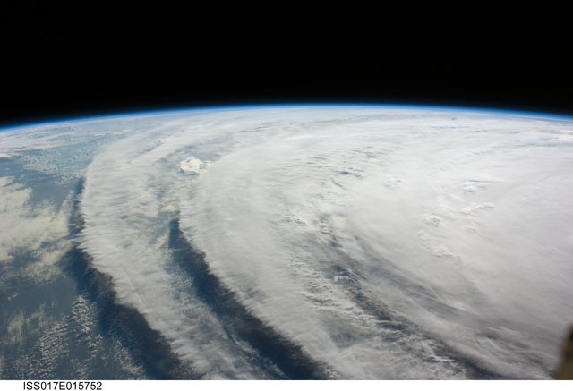 Figure 1. Image of Hurricane Ike from the International Space Station. Image credit: NASA. The forecast Ike is attempting to create a new eyewall, and visible satellite loops and Galveston radar suggest the storm is becoming more organized. However, Ike has only a few more hours over water, and there is not time for the hurricane to intensify more than 5-10 mph before landfall. Ike will not inflict extreme wind damage like Katrina's or Rita's. The big story with Ike will be the storm surge.  Figure 2.Current tide levels in Galveston. The green line shows the current storm surge, which was 7.5 feet at 4 pm CDT. The water level stopped rising at 2 pm because the tide began going out. When high tide comes back in at 2 am, there will be a sharp rise in the water level. There is a 2 foot difference between high tide and low tide. Image credit: NOAA TIdes and Currents. Ike's storm surge According to the NOAA tide gauges, storm tides are running 6-8 feet above normal along the central Louisiana coast this afternoon. The nola.com web site is reporting that a 9 foot storm surge affected the Industial Canal in New Orleans. Extensive flooding of low lying towns outside the New Orleans levee system is occurring. Surge overtopped a St. Mary Parish levee near the town of Gordy, and a six-foot-wide breach was reported in a non-federal parish levee near the towns of Caernarvon, Scarsdale, White Ditch and Braithwaite. The fact that Ike's storm surge has reached such high levels 200-300 miles north of the storm is a very bad omen for the upper Texas and western Louisiana coasts. The latest forecast surge values from NOAA: Shoreline of Galveston Bay... 15 to 22 feet Bolivar Peninsula... 17 to 20 feet Galveston Island... ... 14 to 17 feet Gulf-facing coastline from Sargent to San Luis Pass... 8 to 14 feet I've given the mistaken impression that the Galveston sea wall will save the city from inundation. That is not the case. The wall merely protects the city from a frontal assault by the storm surge and the 20 foot waves likely to be on top of the surge. Ike will flood the city of Galveston. However, the predicted level of surge will be just beneath the sea wall. If the surge exceeds the 17 foot forecast, it will overtop the sea wall and act like a battering ram against the buildings in Galveston. It is also possible that the sea wall will be destroyed along some sections, allowing the ocean direct access to Galveston. The situation is also grim for Port Arthur, Texas, on the Louisiana border. The expected storm surge of 15-20 feet will overtop the city's seawall by six feet, resulting in flooding of the city and a number of major oil refineries. Expect a significant tightening of gas supplies in coming months, due to extensive damage to the oil refineries in the Houston and Port Arthur area. Ike's winds in Houston and inland Winds in the Houston metro area will increase to tropical storm force--39 mph--early this evening, and remain that strong for about 20 hours. Houston will be on the left (weak) side of Ike, and will miss the storm's strongest winds. Nevertheless, winds of Category 1 hurricane force (75-85 mph) will affect the city for about a 4-hour period in the early morning hours of Saturday. People in well-built homes will suffer only minor damage, but mobile homes and homes not build to code will suffer significant damage. The extremely long duration of the hurricane force winds will cause much greater damage than is typical for a hurricane of this strength. Winds and damage in Houston will be less than was experienced during Hurricane Alicia of 1983. Ike's damage will cover a much wider area and spread farther inland, due to the large size of the storm. During Alicia, Houston Hobby Airport on the south side of the city recorded top winds of 89 mph, gusting to 99 mph. The strongest winds recorded at Houston International Airport, on the north side of the city, were 51 mph, gusting to 78 mph. Winds from Ike will probably reach maximum sustained speeds of 75-80 mph at Houston Hobby, and 65-70 mph at Houston International Airport. A good guess on what kind of winds inland areas will experience can be had by using the Inland Wind Model developed by NOAA scientists Mark DeMaria and John Kaplan. This simple model shows the expected winds inland from the coast for the five Category hurricanes moving at different speeds. Plotted below (Figure 3) is the inland wind model plot that best fits the type of winds I expect will penetrate inland from Ike. I think Ike will be a strong Category 2 hurricane moving at about 15 mph at landfall, but the hurricane's strongest winds will penetrate farther inland than is typical due to the huge size of the storm. Thus, I picked a slightly stronger storm with a higher forward speed to base my inland wind estimate on. I expect hurricane force winds of 74 mph will penetrate about 110 miles inland, near the cities of Huntsville and Livingston to the north of Galveston, and not quite reaching Lufkin. We can expect Ike to cause the largest and longest-lived power outage in Texas history, with power knocked out along a 200-mile wide swath in eastern Texas and extreme western Louisiana extending 300 miles inland to I-20. Dallas will be at the fringe of the region of widespread power outages, and should not suffer major power failures. 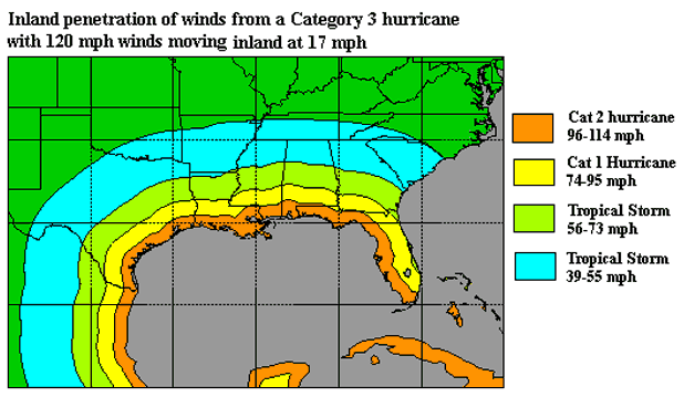 Figure 3. Inland penetration of tropical storm and hurricane force winds from a Category 3 hurricane with 120 mph winds moving perpendicular to the Gulf Coast at a forward speed of 17 mph. Image credit: NOAA. For more information I recommend Texas residents consult NHC's wind probability product to determine their odds of getting hurricane force winds. For storm surge evacuation zone information, consult the Texas Division of Emergency Management. For storm surge heights, consult our Storm surge risk for the Texas coast page. Links to follow Galveston, TX weather Port Arthur, TX weather Houston, TX weather Tide gauges along the Gulf Coast Long-range radar out of Galveston, TX wundermap of weather stations near Ike Buoy 42035 22 nm SE of Galveston I-45 traffic cams (bottom 6 on scroll-down menu are Galveston). Tropical disturbance approaching the central Bahamas An area of disturbed weather (91L) is located about 400 miles east of the central Bahamas, and is moving west-northwest at 10-15 mph. Satellite loops show that 91L's heavy thunderstorms have continued to increase in areal coverage this afternoon. However, these thunderstorms are not well organized, and there is no evidence of a surface circulation yet on visible satellite imagery. The disturbance is under about 10 knots of wind shear, and is also having trouble with some dry air to the west. There is an upper-level low pressure just to the west of 91L that is creating shear and pumping dry air into the system, similar to the situation Hanna had to deal with in its formative stages. Shear is expected to remain 10-20 knots though Monday, which may allow some gradual development. None of the models are developing 91L, but the central Bahamas can expect heavy rain and strong gusty winds Saturday. These conditions may spread to the western Bahamas by Sunday and the east coast of Florida by Monday. NHC is giving this disturbance a low (<20% chance) of developing into a tropical depression by Sunday. A Hurricane Hunter aircraft is on call to fly into 91L on Sunday, if necessary. Jeff Masters
Hurricane Ike
is closing in on Texas, and stands poised to become one of the most
damaging hurricanes of all time. Despite Ike's rated Category 2
strength, the hurricane is much larger and more powerful than Category
5 Katrina or Category 5 Rita. The storm surge from Ike could rival
Katrina's, inundating a 200-mile stretch of coast from Galveston to
Cameron, Louisiana with waters over 15 feet high. This massive storm
surge is due to the exceptional size of Ike. According to the latest
wind field estimate (Figure 1), the diameter of Ike's tropical storm
and hurricane force winds are 550 and 240 miles, respectively. For
comparison, Katrina numbers at landfall were 440 and 210 miles,
respectively. As I discussed in yesterday's blog entry,
a good measure of the storm surge potential is Integrated Kinetic
Energy (IKE). Ike continues to grow larger and has intensified slightly
since yesterday, and the hurricane's Integrated Kinetic Energy has
increased from 134 to 149 Terajoules. This is 30% higher than Katrina's
total energy at landfall. All this extra energy has gone into piling up
a vast storm surge that will probably be higher than anything in
recorded history along the Texas coast. Storm surge heights of 20-25
feet are possible from Galveston northwards to the Louisiana border.
The Texas storm surge record is held by Hurricane Carla
of 1961. Carla was a Category 4 hurricane with 145 mph winds at
landfall, and drove a 10 foot or higher storm surge to a 180-mile
stretch of Texas coast. A maximum storm surge of 22 feet was recorded
at Port Lavaca, Texas.
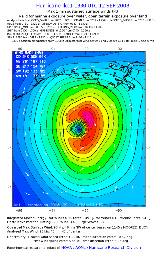 Figure 1. Experimental wind field analysis for Ike at 9:30 am EDT 09/12/08. The area of hurricane force winds is inside the heavy black line where the yellow color begins (64 knots). The area of tropical storm force winds is inside the heavy black line at 35 knots (turquoise colors). The total Integrated Kinetic Energy was 149 Terajoules, which makes Ike's storm surge potential a 5.4 on a scale of 1 to 6. Image credit: NOAA Hurricane Research Division. The forecast Ike's small inner eyewall has completely collapsed, leaving Ike with no eyewall. Creation of a new eyewall is being hampered by some dry air to the storm's west, and the presence of about 10 knots of wind shear. However, Ike is beginning to look better organized on satellite imagery, and may still intensify by 5-10 mph before landfall. Ike will not inflict extreme wind damage like Katrina's or Rita's. The big story with Ike will be the storm surge. Ike's winds An oil rig in Ike's path measured sustained winds of 125 mph, at 6:45 am CDT. Lower winds of 105 mph were occurring at the surface, since the rig is at an elevation of 400 feet. The Hurricane Hunters are still reporting maximum winds of 105 mph over a large region of the surface. Ike's storm surge According to the NOAA tide gauges, storm tides along the Mississippi coast peaked at about 6 feet above normal yesterday, with a 7 foot storm tide observed on the east side of New Orleans at Shell Beach in Lake Borgne. At 10 am CDT, storm tides of 5-6 feet were being seen in western Louisiana, and were 5 feet at Freeport, Texas, and 5.5 feet at Galveston. According to the latest NWS forecast from the Galveston office, we can expect the following storm surges in Texas: Gulf-facing coastline west of Sargent... 4 to 6 feet Shoreline of Matagorda Bay... 2 to 5 feet Gulf-facing coastline from Sargent to San Luis Pass... 12 to 15 feet Gulf-facing coastline San Luis Pass to High Island including Galveston Island... ... 15 to 20 feet Shoreline of Galveston Bay...15 to 25 feet NOAA's experimental storm surge forecast is calling for a 10% chance that the storm tide from Ike will reach 27-30 feet on the south and east sides of Houston. The exact track of Ike is key in determining if Galveston's 17-foot sea wall gets overtopped, flooding the city. A slight wobble 30 miles to the north of Galveston would put the city into offshore winds from Ike, possibly saving it from inundation. The situation is grim for Port Arthur, Texas, on the Louisiana border. The expected storm surge of 15-20 feet will overtop the city's seawall by six feet, resulting in flooding of the city and a number of major oil refineries. Expect a significant tightening of gas supplies in coming months, due to extensive damage to the oil refineries in the Houston and Port Arthur area. Ike's winds in Houston and inland Winds in the Houston metro area will increase to tropical storm force--39 mph--by about 4 pm CDT today, and remain that strong for about 24 hours. Category 1 hurricane force winds of about 75-85 mph will affect the city for about an 8-hour period from midnight to 8 am on Saturday. People in well-built homes will suffer only minor damage, but mobile homes and homes not build to code will suffer significant damage. The extremely long duration of the hurricane force winds will cause much greater damage than is typical for a hurricane of this strength. Winds and damage in Houston should will be slightly greater than was experienced during Hurricane Alicia of 1983. Alica had higher winds at landfall, but was a smaller storm that weakened relatively quickly inland. Ike's damage will cover a much wider area and spread farther inland, due to the large size of the storm. During Alicia, Houston Hobby Airport on the south side of the city recorded top winds of 89 mph, gusting to 99 mph. The strongest winds recorded at Houston International Airport, on the north side of the city, were 51 mph, gusting to 78 mph. Winds from Ike will probably be sustained at 85-90 mph at Houston Hobby, and 75-80 mph at Houston International Airport. A good guess on what kind of winds inland areas will experience can be had by using the Inland Wind Model developed by NOAA scientists Mark DeMaria and John Kaplan. This simple model shows the expected winds inland from the coast for the five Category hurricanes moving at different speeds. Plotted below (Figure 2) is the inland wind model plot that best fits the type of winds I expect will penetrate inland from Ike. I think Ike will be a strong Category 2 hurricane moving at about 15 mph at landfall, but the hurricane's strongest winds will penetrate farther inland than is typical due to the huge size of the storm. Thus, I picked a slightly stronger storm with a higher forward speed to base my inland wind estimate on. I expect hurricane force winds of 74 mph will penetrate about 110 miles inland, near the cities of Huntsville and Livingston to the north of Galveston, and not quite reaching Lufkin. We can expect Ike to cause the largest and longest-lived power outage in Texas history, with power knocked out along a 200-mile wide swath in eastern Texas and extreme western Louisiana extending 300 miles inland to I-20. Dallas will be at the fringe of the region of widespread power outages, and should not suffer major power failures. Figure 2. Inland penetration of tropical storm and hurricane force winds from a Category 3 hurricane with 120 mph winds moving perpendicular to the Gulf Coast at a forward speed of 17 mph. Image credit: NOAA. Tornadoes from Ike Texas hurricanes have a history of producing strong tornadoes. Hurricane Alica spawned 23 tornadoes when it hit, including one strong F2 tornado. Hurricane Carla of 1961 unleashed 26 tornadoes, including the only violent F4 tornado ever spawned by a hurricane. The tornado hit Galveston, killing between 6 and 12 people. Rain Heavy rain from Ike will be the least of Texas' concerns, since the hurricane is not expected to stall, and will move quickly northwards out of the state by Sunday. The latest NOAA/HPC rain forecast (Figure 3) predicts the swath of heaviest rains of six inches or more will cover an area about 100 miles square. 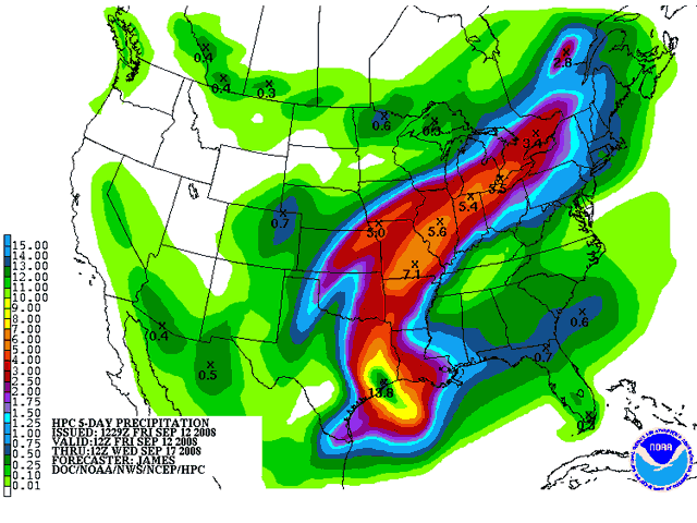 Figure 3. Predicted 5-day rainfall totals along the path of Ike, beginning at 8am EDT Friday September 12, 2008. Image credit: NOAA Hydrometeorological Prediction Center. For more information I recommend Texas residents consult NHC's wind probability product to determine their odds of getting hurricane force winds. For storm surge evacuation zone information, consult the Texas Division of Emergency Management. For storm surge heights, consult our Storm surge risk for the Texas coast page. Links to follow Galveston, TX weather Port Arthur, TX weather Houston, TX weather Tide gauges along the Gulf Coast Long-range radar out of Galveston, TX wundermap of weather stations near Ike Buoy observations near Ike from the National Data Buoy Center. Tropical disturbance 91L north of Puerto Rico An area of disturbed weather (91L) is located a few hundred miles north of the Dominican Republic. Satellite loops show that 91L's heavy thunderstorm has shown a modest increase this morning, but these thunderstorm are not well organized and cover a limited area. This morning's QuikSCAT pass missed 91L, but last night's pass showed no evidence of a surface circulation, and none is apparent on visible satellite imagery. The disturbance is under about 10 knots of wind shear, and is also having trouble with some dry air to the west. There is an upper-level low pressure just to the west of 91L that is creating shear and pumping dry air into the system, similar to the situation Hanna had to deal with in its formative stages. Shear is expected to remain 10-20 knots though Monday, which may allow some gradual development. None of the models are developing 91L, but the Bahamas can expect heavy rain and strong gusty wind over the next three days as 91L tracks west-northwest towards the east coast of Florida. NHC is giving this disturbance a low (<20% chance) of developing into a tropical depression by Sunday. Jeff Masters
Hurricane Ike
remains a huge a dangerous Category 2 hurricane, and has changed little
since this morning. Ike's central pressure continues to hold steady at
950 mb, as measured by the Hurricane Hunters at 3:14 pm EDT. Ike's tiny
9-mile wide eye appears to be collapsing, which will allow a new
eyewall of much larger-diameter to form. This event should allow Ike to
start intensifying tonight. The latest Tropical Cyclone Heat Potential
image shows that the center of Ike has just finished crossing a cold
eddy in the Gulf of Mexico waters, and is now beginning to pass along
the north side of a warm eddy. This change in oceanic heat should also
help allow Ike to intensify tonight. The eddy is not ideally
positioned, though, for rapid intensification to occur. The eddy is on
the left (weak) side of the hurricane, where wind speeds are slower
since the forward motion of the storm subtracts from the wind speed of
the circulation. These lower-speed winds will be able to evaporate less
moisture from the warm ocean than if the eddy were positioned on Ike's
right side. Oceanic heat content remains moderately high after Ike
crosses the eddy, which should allow some modest strengthening to
continue. Wind shear of 10-15 knots and dry air on Ike's west side is
hampering Ike slightly, as evidenced by the lack of upper-level outflow
on the storm's west side and lack of heavy thunderstorm activity. Shear
is expected to decrease to 5 knots by the time of landfall Saturday
morning, and I expect Ike will be maintaining its strength or slowly
intensifying right up until landfall. Ike will probably be at the top
end of Category 2 strength at landfall, with 110 mph winds.
Comparisons to Carla and Katrina Ike is larger than Katrina was, both in its radius of tropical storm force winds--275 miles--and in it radius of hurricane force winds--115 miles. For comparison, Katrina's tropical storm and hurricane force winds extended out 230 and 105 miles, respectively. Ike's surge will probably rival the massive storm surge of Hurricane Carla of 1961. Carla was a Category 4 hurricane with 145 mph winds at landfall, and drove a 10 foot or higher storm surge to a 180-mile stretch of Texas coast. A maximum storm surge of 22 feet was recorded at Port Lavaca, Texas. Despite the fact that the center of Carla hit over 120 miles southwest of Houston, the hurricane drove a 15-foot storm surge into the bays along the south side of the city. Ike's maximum surge is not likely to reach the extreme values above 20 feet seen in Hurricane Carla, though. 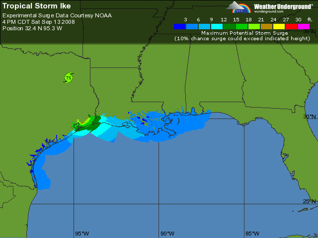 Figure 1. Experimental storm surge heights for Ike. There is a 10% chance the storm surge from Ike will exceed these values. Data courtesy of NOAA. The total energy of Ike The amount of water Ike has put in motion is about 10% greater than what Katrina did, and thus we can expect Ike's storm surge damage will be similar to or greater than Katrina's. The way we can estimate this damage potential is to compute the total energy of Ike's surface winds (kinetic energy). To do this, we must look at how strong the winds are, and factor in the areal coverage of these winds. Thus, we compute the Integrated Kinetic Energy (IKE) by squaring the velocity of the wind and summing over all regions of the hurricane with tropical storm force winds or higher. This "Integrated Kinetic Energy" was recently proposed by Dr. Mark Powell of NOAA's Hurricane Research Division as a better measure of the destructive power of a hurricane's storm surge than the usual Category 1-5 Saffir-Simpson scale. For example, Hurricane Katrina hit Mississippi as a strong Category 3 hurricane, yet its storm surge was more characteristic of a Category 5 storm. Dr. Powell came up with a new scale to rate potential storm surge damage based on IKE (not to be confused with Hurricane Ike!) The new scale ranges from 1-6. Katrina and Wilma at their peaks both earned a 5.1 on this scale (Figure 2). At 12:30pm EDT today, Ike earned a 5.2 on this scale, the second highest kinetic energy of any Atlantic storm in the past 40 years. Hurricane Isabel of 2003 had the highest. Note that the figures I quoted in this morning's blog saying Ike had an IKE of 180, 50% higher than Katrina's, were found to be in error due to some bad data from one of the Hurricane Hunter observations (the IKE is an experimental product, after all). Thus, this morning's IKE was actually a little lower than Katrina's. 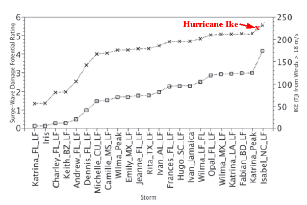 Figure 2. Comparison of the potential damage from storm surge and waves on a scale of 1 to 6 (left scale, and corresponding to little "x" marks on the plot), as a function of total Integrated Kinetic Energy in Tera-joules (IKE, on the right scale, corresponding to the little squares on the plot). Hurricane Ike at 12:30pm EDT had an IKE of 134, 10% higher than the value of 122 Katrina had at landfall in Mississippi. Ike's amount of wind energy can generate storm surge and wave damage rated at 5.2 on a scale of 1 to 6, worse than Katrina's 5.1 at landfall. Image credit:"Tropical Cyclone Destructive Potential by Integrated Kinetic Energy" by Mark Powell and Timothy Reinhold. Ike's waves All this energy is also going into the waves in the Gulf of Mexico, and the offshore oil rigs can expect to receive a terrific battering. At 1:50pm CDT, waves at the buoy 42001 180nm south of Louisiana peaked at 30 feet. NHC is predicting Ike's waves will peak at 50 feet (15 meters) in the northern Gulf on Friday. For comparison, Hurricane Ivan of 2004 generated 27 meter (89 foot) high waves in the Gulf of Mexico. The oil companies spent hundreds of millions of dollars upgrading their oil rigs in the Gulf in the wake of the destruction wrought by Ivan and Katrina and Rita, and I'm not anticipating severe damage to the rigs from Ike's 50-foot waves. Ike's storm surge According to the NOAA tide gauges, the storm tides along the Mississippi coast have peaked at 4 feet above normal, and are currently running 5 feet above normal on the east side of New Orleans at Shell Beach in Lake Borgne. A storm surge of 5.9 feet was observed in New Orleans' Industrial Canal at 10:45 am CDT, and 5.75 feet in Waveland, Mississippi. Coastal Alabama is reporting a 4-6 foot storm surge, with 10-15 foot waves. Considering the center of Ike is over 250 miles south of these locations, it is not hard to imagine that Texas will get a 15-20 foot storm surge, even if Ike does not strengthen. Ike will probably inundate a 250-mile stretch of Texas coast from Port O'Connor to the Louisiana border with a 10-15 foot storm surge. This will occur even if Ike is a Category 1 storm at landfall. If Ike is a Category 3+ hurricane at landfall, surges of 20+ feet are possible. The latest experimental storm surge forecast From NOAA's SLOSH model (Figure 1) shows a 10% chance that Ike's storm surge will exceed 18-21 feet at Galveston. The Galveston sea wall is 17 feet high, so it may get overtopped. At noon today, a mandatory evacuation of the entire island was ordered in case this worst-case scenario is realized. The official NHC forecast is calling for maximum storm surge heights of 20 feet. What should Texas residents do? We must assume Ike will intensify to a Category 3 hurricane by landfall, which would likely do $20-$30 billion in damage. Ike's storm surge is going to be affect a huge area and be tremendously destructive. The latest Hurricane Local Statement from the Galveston National Weather Service office puts things in pretty stark perspective: All neighborhoods... and possibly entire coastal communities... will be inundated during high tide. Persons not heeding evacuation orders in single family one or two story homes will face certain death. Many residences of average construction directly on the coast will be destroyed. Widespread and devastating personal property damage is likely elsewhere. Vehicles left behind will likely be swept away. Numerous roads will be swamped... some may be washed away by the water. Entire flood prone coastal communities will be cutoff. Water levels may exceed 9 feet for more than a mile inland. Coastal residents in multi-story facilities risk being cutoff. Conditions will be worsened by battering waves. Such waves will exacerbate property damage... with massive destruction of homes... including those of block construction. Damage from beach erosion could take years to repair. I recommend Texas residents consult NHC's wind probability product to determine their odds of getting hurricane force winds. For storm surge evacuation zone information, consult the Texas Division of Emergency Management. For storm surge heights, consult our Storm surge risk for the Texas coast page. Links to follow Galveston, TX weather Tide gauges along the Gulf Coast Mid Gulf Buoy 180 nm South of Southwest Pass, LA (42001) Tropical disturbance 91L north of Puerto Rico An area of disturbed weather (91L) has developed a few hundred miles north of Puerto Rico. Satellite loops show that 91L has a very small amount of heavy thunderstorm activity, but does have a circulation at middle levels of the atmosphere. A surface circulation is not apparent, but the mid-level spin could work its way down to the surface over the next day or two. The disturbance in under about 20 knots of wind shear, and is also having trouble with some dry air to the west. Shear is expected to remain 10-20 knots though Saturday, then increase to 25 knots. We may expect some slow development until Saturday, when wind shear should be too high to allow further development. None of the models are developing 91L. By Tuesday, as 91L will be approaching the east coast of Florida, shear is expected to decline to 15 knots, and some additional development may be possible, if the disturbance holds together that long. I'll have an update tonight if there's a significant change in Ike. Jeff Masters
Hurricane Ike's
winds remain at Category 2 strength, but Ike is a freak storm with
extreme destructive storm surge potential. Ike's pressure fell rapidly
last night to 944 mb, but the hurricane did not respond to the pressure
change by increasing its maximum winds in the eyewall. Instead, Ike
responded by increasing the velocity of its winds away from the
eyewall, over a huge stretch of the Gulf of Mexico. Another very
unusual feature of Ike is the fact that the surface winds are much
slower than the winds being measured aloft by the Hurricane Hunters.
Winds at the surface may only be at Category 1 strength, even though
Ike has a central pressure characteristic of a Category 3 or 4 storm.
This very unusual structure makes forecasting the future intensity of
Ike nearly impossible. The possibilities range from a Category 1 storm
at landfall--as predicted by the HWRF model--to a Category 4 storm at
landfall, as predicted by the GFDL.
Ike is now larger than Katrina was, both in its radius of tropical storm force winds--275 miles--and in it radius of hurricane force winds--115 miles. For comparison, Katrina's tropical storm and hurricane force winds extended out 230 and 105 miles, respectively. Ike's huge wind field has put an extraordinarily large volume of ocean water in motion. When this swirling column of water hits the shallow waters of the Continental Shelf, it will be be forced up into a large storm surge which will probably rival the massive storm surge of Hurricane Carla of 1961. Carla was a Category 4 hurricane with 145 mph winds at landfall, and drove a 10 foot or higher storm surge to a 180-mile stretch of Texas coast. A maximum storm surge of 22 feet was recorded at Port Lavaca, Texas. Despite the fact that the center of Carla hit over 120 miles southwest of Houston, the hurricane drove a 15-foot storm surge into the bays along the south side of the city. I don't expect Ike will reach Category 4 strength, thus its maximum surge is not likely to reach the extreme values above 20 feet seen in Hurricane Carla. Like Carla, though, Ike will probably inundate a 180-mile stretch of Texas coast from Port O'Connor to just north of Galveston with a 10-15 foot storm surge. This will occur even if Ike is a Category 1 storm at landfall. The latest experimental storm surge forecast From NOAA's SLOSH model (Figure 1) shows a 10% chance that Ike's storm surge will exceed 15-21 feet at Galveston. The Galveston sea wall is 17 feet high, so it may get overtopped. Figure 1. Experimental storm surge heights for Ike. There is a 10% chance the storm surge from Ike will exceed these values. Data courtesy of NOAA. The amount of water Ike has put in motion is about 50% greater than what Katrina did, and thus we can expect Ike's storm surge damage will be similar to or greater than Katrina's. The way we can estimate this damage potential is to compute the total energy of Ike's surface winds (kinetic energy). To do this, we must look at how strong the winds are, and factor in the areal coverage of these winds. Thus, we compute the Integrated Kinetic Energy (IKE) by squaring the velocity of the wind and summing over all regions of the hurricane with tropical storm force winds or higher. This "Integrated Kinetic Energy" was recently proposed by Dr. Mark Powell of NOAA's Hurricane Research Division as a better measure of the destructive power of a hurricane's storm surge than the usual Category 1-5 Saffir-Simpson scale. For example, Hurricane Katrina hit Mississippi as a strong Category 3 hurricane, yet its storm surge was more characteristic of a Category 5 storm. Dr. Powell came up with a new scale to rate potential storm surge damage based on IKE (not to be confused with Hurricane Ike!) The new scale ranges from 1-6. Katrina and Wilma at their peaks both earned a 5.1 on this scale (Figure 2). At 9:30am EDT this morning, Ike earned a 5.6 on this scale, the highest kinetic energy of any Atlantic storm in the past 40 years. Figure 2. Comparison of the potential damage from storm surge and waves on a scale of 1 to 6 (left scale, and corresponding to little "x" marks on the plot), as a function of total Integrated Kinetic Energy in Tera-joules (IKE, on the right scale, corresponding to the little squares on the plot). Hurricane Ike at 12:30pm EDT had an IKE of 134, 10% higher than the value of 122 Katrina had at landfall in Mississippi. Ike's amount of wind energy can generate storm surge and wave damage rated at 5.2 on a scale of 1 to 6, worse than Katrina's 5.1 at landfall. Image credit:"Tropical Cyclone Destructive Potential by Integrated Kinetic Energy" by Mark Powell and Timothy Reinhold. All this energy is also going into the waves in the Gulf of Mexico, and the offshore oil rigs can expect to receive a terrific battering. At 8:50am CDT, waves at the Buoy 42001 180nm south of Louisiana were 28 feet and growing. NOAA's Wavewatch III model is predicting wave heights up to 13 meters from Ike on Friday. For comparison, Hurricane Ivan of 2004 generated 27 meter high waves in the Gulf of Mexico. Surf heights of 15 feet have been reported at beaches along the Florida Panhandle, and tides are also running extremely high. Tides are 2-4 feet above normal along the Gulf Coast from Louisiana to the west coast of Florida, and one foot above normal in Galveston. The water level will continue to rise as Ike approaches Texas, and NOAA's experimental storm surge forecast (Figure 1) is calling for a 10% chance that the storm tide from Ike will reach 24-27 feet on the south and east sides of Houston. What should Texas residents do? We must assume Ike will intensify to a Category 3 hurricane by landfall, which would likely do $20-$30 billion in damage. The chances of hundreds of people being killed in this storm is high if people do not heed evacuation orders to leave low-lying areas threatened by high storm surges. Ike's storm surge is going to be affect a huge area and be tremendously destructive. I recommend Texas residents consult NHC's wind probability product to determine their odds of getting hurricane force winds. For storm surge evacuation zone information, consult the Texas Division of Emergency Management. For storm surge heights, consult our Storm surge risk for the Texas coast page. Links to follow Tide gauges along the Gulf Coast Mid Gulf Buoy 180 nm South of Southwest Pass, LA (42001) I'll have much more in this afternoon's blog, including a look at the rest of the tropics. We've got a new area of disturbed weather to watch, Invest 91L. Jeff Masters
Hurricane Ike
is intensifying dramatically. The central pressure has dropped 11 mb in
just four hours, and stood at 947 mb at 7 pm EDT. The latest Hurricane
Hunter data show that the pressure is continuing to fall at a rapid
pace. The winds have not caught up yet to the pressure fall, and remain
at Catgeroy 2 strength. The satellite presentation of the hurricane has
improved markedly, as Ike has walled off the dry air that was bothering
it, and has built a solid eyewall of 9 miles diameter of very intense
thunderstorms. The appearance of Ike on infrared satellite loops
is similar to Hurricane Wilma during its rapid intensification phase,
when Wilma became the strongest hurricane on record. Like Wilma, Ike
has a very tiny "pinhole" eye, but the storm is huge in size. Ike has a
long way to go to match Wilma, but I expect Ike will be at least a
Category 3 hurricane by morning, and probably a Category 4.
Figure 1. Experimental storm surge heights for Ike. There is a 10% chance the storm surge from Ike will exceed these values. Data courtesy of NOAA. Ike is almost as large as Katrina was, and this large wind field is already beginning to pile up a formidable storm surge. Tides are running 2-4 feet above normal along the Gulf Coast from Louisiana to the west coast of Florida. Tides have risen one foot above normal in Galveston too. The water level will continue to rise as Ike approaches Texas, and NOAA's experimental storm surge forecast (Figure 1) is calling for a 10% chance that the storm tide from Ike will reach 10-12 feet at Galveston, and 18-21 feet on the south and east sides of Houston. Ike is likely to be a extremely dangerous major hurricane at landfall, and will likely do $10-$30 billion in damage. The chances of hundreds of people being killed in this storm is high if people do not heed evacuation orders. It is possible that Ike will make a direct hit on Galveston as a Category 4 hurricane with 145 mph winds. The potential storm surge from such a hit could be in the 15-25 foot range (Figure 2), which is capable of overwhelming the 17 foot sea wall in Galveston. I put the odds of such an event at about 5%. 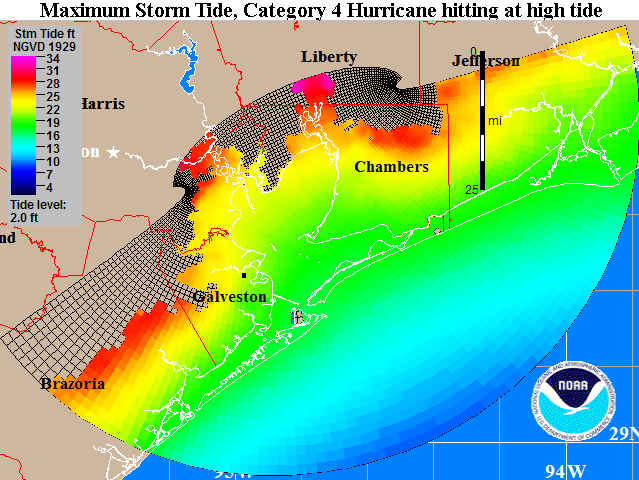 Figure 2. The maximum storm tide (storm surge plus an adjustment for hitting at high tide) expected from a mid-strength (145 mph) Category 4 hurricane hitting anywhere along the coast of Texas at high tide. This so-called "MOM" (Maximum Of the Maximum Envelope Of Waters) is computed using NOAA's SLOSH storm surge model. The plot above IS NOT the expected storm tide everywhere along the coast from a hit by Hurricane Ike. The plot is the MAXIMUM high water for a worst-case scenario Category 4 hurricane moving at the worst possible angle at the worst possible forward speed. As such, this plot is the combination of SLOSH runs from over 50 different simulated hurricanes approaching the coast at different angles and different forward speeds. The maximums plotted here are only possible along a 20-mile stretch of the coast on the north side of Ike's eyewall. SLOSH model runs are advertised as being in error by plus or minus 20%. Image credit: NOAA. Track forecast for Ike The latest 18Z (2pm EDT) computer models are still in poor agreement. The GFDL still has Ike making landfall at Galveston as a borderline Category 3 or 4 hurricane, and the rest of the models have landfall farther south, near Port O'Connor. With a trough of low pressure expected to turn Ike northwestward close to landfall time, slight variations in the timing of this trough among the models is causing a large spread in landfall locations. The cone of uncertainty still covers the entire Texas coast, and residents of southwestern Louisiana are also at risk. I recommend Texas residents consult NHC's wind probability product to determine their odds of getting hurricane force winds. At 5 pm EDT, NHC called for these odds of getting hurricane force winds at various Texas cities: Corpus Christi: 15% Port O'Connor: 26% Freeport: 30% Galveston: 25% Houston: 20% Port Arthur: 13% As you can see, Freeport is considered the most likely city in Texas to receive hurricane force winds. I believe the percentages for the cities above are too low, and should be bumped up by 5-10%. Intensity forecast for Ike The intensity forecast remains the same. Water temperatures are a warm 29.5°C in the Gulf of Mexico, and wind shear is expected to be modest, 10-15 knots, for the remainder of Ike's life. Ike will be skirting the edge of a warm Loop Current eddy, but the heat content of the waters near the Texas coast are high. Ike has the capability of intensifying right up to landfall. This is the forecast of the HWRF model, which has Ike hitting Port O'Connor as a Category 4 hurricane with 145 mph winds. The weakest I think Ike will be at landfall is a Category 2 hurricane with 100 mph winds. Even at this weak strength, Ike will still carry a 10-15 foot storm surge to a 100+ mile long stretch of Texas coast. Storm surge risk We've put together today a page of storm surge risks for the Texas coast. These images show the maximum storm tide (storm surge plus an adjustment for hitting at high tide) expected from a mid-strength hurricane of each Saffir-Simpson Category hitting anywhere along the coast of Texas at high tide. These so-called "MOMs" (Maximum Of the Maximum Envelope Of Waters) are computed using NOAA's SLOSH storm surge model. A sample image is shown in Figure 1 for a Category 4 hurricane affecting the Galveston area. A storm of this magnitude is expected to bring a maximum 22 foot storm tide (storm surge plus a 2-foot adjustment in case it hits at high tide) to Galveston. A maximum 28-foot storm tide could affect the built-up areas along the east side of Houston. Note that some Category 4 hurricanes making a direct hit on Galveston will bring a significantly lower storm surge than the worst-case 22-foot scenario pictured here. For example, the Great Galveston Hurricane of 1900 was a Category 4 storm that hit the city head-on, but generated a storm surge of only 15 feet. Even so, this hurricane was the deadliest disaster in American history, killing an estimated 8,000-12,000 people. Since then, Galveston has built its seawall to a height of 17 feet, which would probably withstand a direct hit by Ike at Category 4 strength. For storm surge evacuation zone information, consult the Texas Division of Emergency Management. Links to follow Tide gauges along the Gulf Coast Storm surge risk for the Texas coast I'll be speaking at hurricanecity.com tonight at 9:30pm EDT. I'll be posting a new blog Thursday morning. Jeff Masters
Hurricane Ike
has grown into a very large and powerful Category 2 hurricane. At 2 pm
EDT, the Hurricane Hunters found maximum winds had increased to 100
mph. This increase in winds was a reaction to the 10 mb drop in
pressure noted in the past 12 hours. The most recent pressure
measured--958 mb at 3:09 pm EDT--was actually a 1 mb increase from the
10 am reading, indicating that Ike's intensity has likely leveled off
for now. Visible satellite loops
show that Ike has ingested some dry air from the west, which is visible
as a spiral dark streak that wraps into the core of the storm. The
small 11-mile diameter eye occasionally pops into view, and is
exhibiting the unusual behavior of orbiting around in a large circle
within the hurricane. Hurricane Wilma of 2005--the strongest hurricane
on record--exhibited this behavior during its intensification phase, as
well. However, Wilma was not sucking in dry air at the time, and Ike is
not likely to approach Wilma's ferocity.
A large spiral band surrounding Ike's inner eye is attempting to close off and form a new outer eyewall with a diameter of 100 miles. The power struggle between the small inner eyewall and the large outer spiral band will likely go on until Thursday, resulting in little intensification of Ike this evening. By Thursday, the power struggle will likely be over, and Ike will probably resume intensification. If the small eyewall wins, Ike could intensify rapidly to a Category 4 hurricane; if the large spiral band takes over as the new eyewall and the inner eyewall crumbles, we can expect more gradual intensification to a Category 3 hurricane. Ike continues to grow in size, and its tropical storm force winds extend out almost as far as Katrina's did. This large wind field is already starting to pile up a formidable storm surge. Tides are already running 2-4 feet above normal along the Gulf Coast from Louisiana to the west coast of Florida. Visible satellite loops show that Ike has good upper-level outflow channels open to the north and the south. Outflow and cloud cover are restricted on the storm's west side, where dry air and wind shear of 10-15 knots are affecting the storm. All indications are that Ike will intensify into a major hurricane that will bring widespread destruction to a large stretch of the Texas coast. I expect Ike will generate a 10-15 foot storm surge along a 100-mile stretch of Texas coast from the eye landfall location, northwards. I urge Texas residents to take this storm very seriously and heed any evacuation orders given. Most of you living along the coast have never experienced a major hurricane, and Ike is capable of causing high loss of life in storm surge-prone areas. Tropical storm force winds will spread over the Texas coast beginning Friday afternoon, and evacuations must be completed by Friday morning. All airports in eastern Texas will be forced to close Friday night, and will probably remain closed most of Saturday. Ike has a good chance of becoming the most destructive hurricane in Texas history--though not the most powerful. Figure 1. The maximum storm tide (storm surge plus an adjustment for hitting at high tide) expected from a mid-strength (145 mph) Category 4 hurricane hitting anywhere along the coast of Texas at high tide. This so-called "MOM" (Maximum Of the Maximum Envelope Of Waters) is computed using NOAA's SLOSH storm surge model. The plot above IS NOT the expected storm tide everywhere along the coast from a hit by Hurricane Ike. The plot is the MAXIMUM high water for a worst-case scenario Category 4 hurricane moving at the worst possible angle at the worst possible forward speed. As such, this plot is the combination of SLOSH runs from over 50 different simulated hurricanes approaching the coast at different angles and different forward speeds. The maximums plotted here are only possible along a 20-mile stretch of the coast on the north side of Ike's eyewall. SLOSH model runs are advertised as being in error by plus or minus 20%. Image credit: NOAA. Track forecast for Ike The latest 12Z (8am EDT)) computer models are in even less agreement than the previous set of runs. There has been a northward shift in several models, most notably the GFDL, which now has Ike making landfall at Galveston as a strong Category 3 hurricane. With a trough of low pressure expected to turn Ike northwestward close to landfall time, slight variations in the timing of this trough among the models is causing a large spread in landfall locations. Given the recent trend in the models to take Ike farther north, I would expect more of the models in future runs may be joining the GFDL in predicting a Galveston landfall. The cone of uncertainty still covers the entire Texas coast, and residents of southwestern Louisiana are also at risk. I recommend Texas residents consult NHC's wind probability product to determine their odds of getting hurricane force winds. At 11 am EDT, NHC called for these odds of getting hurricane force winds at various Texas cities: Brownsville: 9% Corpus Christi: 17% Port O'Connor: 24% Freeport: 23% Galveston: 20% Houston: 13% As you can see, Port O'Connor is considered the most likely city in Texas to receive hurricane force winds. I believe the percentages for the cities above except Brownsville and Corpus Christi are too low, and should be bumped up by 5-10%. Intensity forecast for Ike The intensity forecast remains the same. Water temperatures are a warm 29.5°C in the Gulf of Mexico, and wind shear is expected to be modest, 10-15 knots, for the remainder of Ike's life. Ike will be crossing over two regions of high heat content associated with the Loop Current and a Loop Current eddy, and Ike has the capability of intensifying right up to landfall. This is the forecast of the HWRF model, which has Ike hitting Port O'Connor as a Category 4 hurricane with 145 mph winds. The weakest I think Ike will be at landfall is Category 2 hurricane with 100 mph winds. Storm surge risk We've put together today a page of storm surge risks for the Texas coast. These images show the maximum storm tide (storm surge plus an adjustment for hitting at high tide) expected from a mid-strength hurricane of each Saffir-Simpson Category hitting anywhere along the coast of Texas at high tide. These so-called "MOMs" (Maximum Of the Maximum Envelope Of Waters) are computed using NOAA's SLOSH storm surge model. A sample image is shown in Figure 1 for a Category 4 hurricane affecting the Galveston area. A storm of this magnitude is expected to bring a maximum 22 foot storm tide (storm surge plus a 2-foot adjustment in case it hits at high tide) to Galveston. A maximum 28-foot storm tide could affect the built-up areas along the east side of Houston. Note that most Category 4 hurricanes making a direct hit on Galveston will bring a significantly lower storm surge than the worst-case 22-foot scenario pictured here. For example, the Great Galveston Hurricane of 1900 was a Category 4 storm that hit the city head-on, but generated a storm surge of only 15 feet. Even so, this hurricane was the deadliest disaster in American history, killing an estimated 8,000-12,000 people. Since then, Galveston has built its seawall to a height of 17 feet, which would probably withstand a direct hit by Ike at Category 4 strength. For storm surge evacuation zone information, consult the Texas Division of Emergency Management. Ike is a large storm, and will probably attain Category 3 or higher status over the Gulf of Mexico. This will set in motion a huge volume of water that will pile up into a large storm surge once Ike reaches the shallow Continental Shelf waters off the coast of Texas. Even if Ike weakens significantly before landfall, I am still expecting the storm to bring a storm surge 10-15 feet to a 100 mile long stretch of Texas coast from the eye northwards along the Texas coast. High tide on Saturday morning along the Texas coast is at 2am CDT. The range between low tide and high tide along the Texas coast is about 2 feet. Links to follow Both GOES-East and GOES-West are operating in rapid scan mode, and you can see some pretty spectacular animations of Ike at Colorado State University's CIRA/RAMMB site. Tide gauges along the Gulf Coast Storm surge risk for the Texas coast I'll be speaking at hurricanecity.com tonight at 9pm EDT. I'll be posting a new blog by 9pm EDT. Jeff Masters
Hurricane Ike
is steadily intensifying over the warm Gulf of Mexico waters as it
heads west-northwest towards the Texas coast. At 10 am EDT, the
Hurricane Hunters found that the pressure has continued to fall, and
now stands at 957 mb--a 10 mb drop in the past 12 hours. Ike's eyewall
was missing a chunk earlier this morning, but the storm his since put
together a complete eyewall. Visible satellite loops
show that Ike has become better organized in recent hours, with a more
symmetrical appearance, and respectable upper-level outflow channels
open to the north and the south. Outflow and cloud cover is restricted
on the storm's west side, where dry air and wind shear of 10-15 knots
is affecting the storm. Water vapor loops
show that some of this dry air may be getting wrapped into the
circulation, and this could slow Ike's intensification today, until it
can build a stronger eyewall. Ike continues to bring very heavy rains
to western Cuba, southwest Florida, and the Florida Keys, where more
than five inches has fallen (Figure 1). All indications are that Ike
will intensify into a major hurricane that will bring widespread
destruction to a large stretch of the Texas coast. I expect Ike will
generate a 10-15 foot storm surge along a 100-mile stretch of Texas
coast from the eye landfall location, northwards. I urge Texas
residents to take this storm very seriously and heed any evacuation
orders given. Most of you living along the coast have never experienced
a major hurricane, and Ike is capable of causing high loss of life in
storm surge-prone areas.
Figure 1. Current radar-estimated precipitation from Ike. Track forecast for Ike Ike is moving west-northwest under the influence of a blocking ridge of high pressure to its north. As Ike approaches Texas on Friday, a trough of low pressure is expected to pass to the north, potentially turning Ike more to the northwest. Tropical storm force winds will spread over the Texas coast beginning Friday afternoon, and evacuations must be completed by Friday morning. All airports in eastern Texas will be forced to close Friday night, and remain closed most of Saturday. The latest 00Z/06Z (8pm/2am EDT)) computer models have begun to zero in on Corpus Christi to Freeport as the most likely landfall location. However, with a trough of low pressure expected to turn Ike close to landfall time, a slight variation in timing of this trough could put Ike ashore farther north, near Galveston. There is also a chance the ridge pushing Ike west Thursday could be stronger than expected, forcing Ike more to the west towards a Brownsville landfall. However, I believe that this is lower probability, and that Galveston is more likely to get hit than Brownsville. The cone of uncertainty still covers the entire Texas coast. If Ike hits Corpus Christi, it will miss most of the oil platforms in the Gulf of Mexico (Figure 2), but a hit closer to Galveston would seriously disrupt the oil and gas industry. 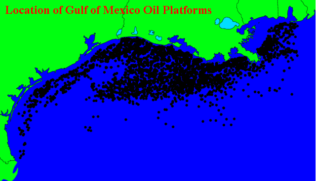 Figure 2. Location of Gulf of Mexico oil platforms. I recommend Texas residents consult NHC's wind probability product to determine their odds of getting hurricane force winds. At 11 am EDT, NHC called for these odds of getting hurricane force winds at various Texas cities: Brownsville: 9% Corpus Christi: 17% Port O'Connor: 24% Freeport: 23% Galveston: 20% Houston: 13% As you can see, Port O'Connor is considered the most likely city in Texas to receive hurricane force winds. I believe the percentages for the cities above except Brownsville are too low, and should be bumped up by 5-10%. Intensity forecast for Ike Ike survived the passage of Cuba well, and remains a large and well-organized hurricane. Significant strengthening is ready to occur, now that Ike has built a new eyewall. I expect Ike will be a Category 2 or 3 hurricane by Wednesday night, and Ike has the potential to become a Category 4 hurricane by Thursday, as forecast by the HWRF and GFDL models. Water temperatures are a warm 29.5°C in the Gulf of Mexico, and wind shear is expected to be modest, 10-15 knots, for the remainder of Ike's life. Ike will be crossing over two regions of high heat content associated with the Loop Current and a Loop Current eddy (Figure 3). There is much higher oceanic heat content off the Texas coast than was present off the Louisiana coast for Gustav. Thus, it is more likely that Ike will be able to maintain major hurricane status as it approaches the coast. The GFDL model predicts landfall near Corpus Christi as a Category 4 hurricane Friday night. The SHIPS model has gotten more aggressive, and now foresees a strong Category 2 hurricane at landfall. Given the impressive appearance of Ike on satellite imagery, and the forecasts of high heat content and low shear along its path, I would be surprised if Ike hit as anything weaker than a Category 2 hurricane with 100 mph winds. Here's my rough probability break-down for Ike's strength at landfall, I forecast a 50% chance Ike will be a major hurricane at landfall: Category 1 or weaker: 20% Category 2: 30% Category 3: 30% Category 4 or 5: 20% 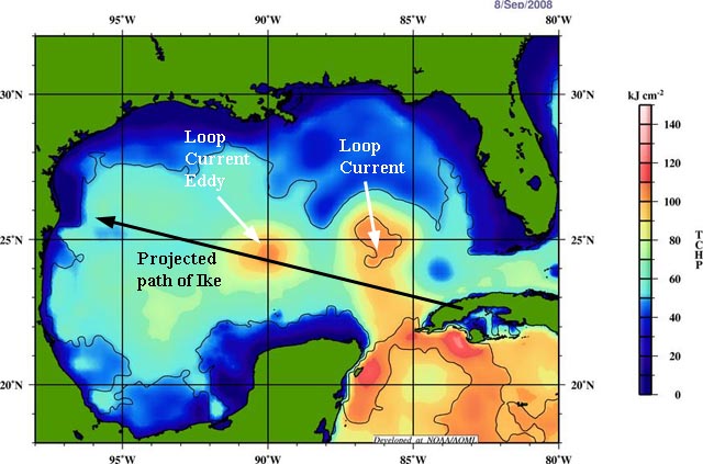 Figure 3. Projected path of Ike overlaid on the current map of Tropical Cyclone Heat Potential (TCHP). TCHP is a measure of total ocean heat content, and TCHP values in excess of 80 kJ/cm^2 (yellow colors) are frequently associated with rapid intensification of hurricanes. Ike will be passing over two regions of high heat content--one associated with the Loop Current, and another associated with an eddy that broke off from the Loop Current in July. Note that heat content stays relatively high all the way to the coast of Texas, in contrast to what Gustav experienced as it approached the coast of Louisiana. Image credit: NOAA/AOML. A comparison to other severe Texas hurricanes There is a significant chance that Ike will be the worst hurricane to hit Texas since Hurricane Celia of 1970. Ike has the potential to be worse than both Hurricane Alicia of 1983 and Hurricane Beulah of 1967, which hit as Category 3 hurricanes. A good benchmark for comparison is probably Hurricane Celia of 1970. Celia followed a similar track to Ike, and intensified steadily right up to landfall, which came over Corpus Christi as a Category 3 storm with 125 mph winds. Celia inflicted severe damage on Corpus Christi and Post Aranasas, with 80% of all buildings in Corpus Christi damaged or destroyed. Damages totaled to $453.8 million, 15 people were killed, and 466 others were injured, mostly by glass shards from shattered windows. Curiously, the storm surge did little damage. According to the NHC post-storm report, "In the entire area of Corpus Christi Bay, Port Aransas, Aransas Pass, and Copano Bay there was no evidence of major damage due to storm surge alone. Not a single house was washed off its foundation. At Port Aransas many modern expensive homes built on pilings 10' or 12' off the ground were a total loss, but not due to water." The high water marks for Celia were 9.2' and 9.0', measured at Port Aransas Beach and Port Aransas jetty, respectively. The relatively low storm surge and light storm surge damage is not likely to be repeated for Ike, since Ike is at least 50% larger than Celia was, and will generate a higher storm surge spread out over a larger region of coast. 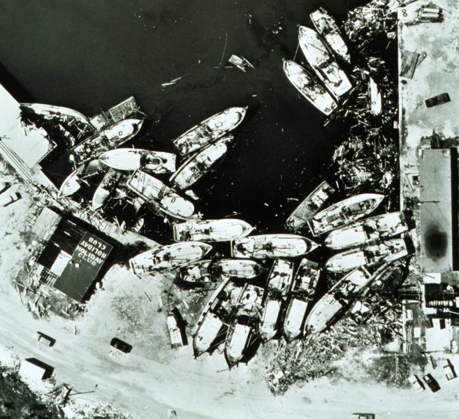 Figure 4. Boats blown ashore at Aransas Pass by Hurricane Celia in 1970. Image credit: NOAA Photo Library. Storm surge risk Ike is a large storm, and will probably attain Category 3 or higher status over the Gulf of Mexico. This will set in motion a huge volume of water that will pile up into a large storm surge once Ike reaches the shallow Continental Shelf waters off the coast of Texas. Even if Ike weakens significantly before landfall, I am still expecting the storm to bring a storm surge of over ten feet to a 100 mile long stretch of Texas coast from the eye northwards along the Texas coast. This is what the August 29, 1942 hurricane did when it hit near Port O'Connor, Texas as a Category 1 storm with 80 mph winds. This was a large hurricane that had been a Category 3 storm with 115 mph winds the day before landfall, allowing it to pile up a large storm surge over the Continental Shelf just offshore the central Texas coast. The storm weakened suddenly in the 12 hours before landfall, but brought a storm surge characteristic of a Category 2 or 3 hurricane to shore. The high angular momentum of the swirling cylinder of ocean water did not have time to decrease much, and a 10-15 foot storm surge came ashore over a 100-mile stretch of coast between Port O'Connor and Freeport (Figure 4). Actually, looking at these storm surge values, I wouldn't be surprised if the 1942 storm was stronger both at landfall and before landfall than the official HURDAT database advertises. This storm came before the era of satellites and Hurricane Hunter aircraft, and I'm guessing too low an intensity was assigned to this storm. 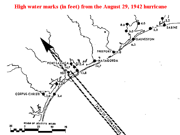 Figure 5. High water marks from the August 29, 1942 hurricane along the Texas coast. Image credit: "Characteristics of the Hurricane Storm Surge", by D. Lee Harris, U.S. Weather Bureau, 1963. The latest run of the HWRF and GFDL models paint a realistic scenario of what could happen to Texas from Ike. These models intensify Ike right up until landfall, hitting between Corpus Christi and Port O'Connor as a Category 3 or 4 hurricane. The HWRF predicts a 120-mile stretch of coast will receive hurricane force winds of 74 mph or greater. An 80-mile stretch of coast will receive winds of Category 3 strength and higher, 115 mph. Hurricane force winds will push inland up to 30 miles, along a 50-mile wide region where the eyewall makes landfall. A 100-mile stretch of Texas coast will receive a storm surge of 10-15 feet, with bays just to the right of where the eye makes landfall receiving a 15-20 foot storm surge. As seen in the maximum storm tide risk map for the Texas coast (Figure 6), a worst-case Category 3 hurricane hitting at high tide will bring a 15-foot storm surge to Corpus Christi, Port O'Connor, or Galveston. Maximum surge values will be higher at the heads of inland estuaries that act to funnel the storm surge as it rushes inland. Ike is already generating tides 2-4 feet above normal along the Gulf Coast from Louisiana to the Florida Panhandle. The scenario above is a little less extreme than what the worst hurricane in Texas history wrought. Hurricane Carla of 1961 was a massive Category 4 hurricane that filled the entire Gulf of Mexico, and brought 145 mph winds to the coast near Port Lavaca. Carla drove a 10 foot or higher storm surge to a 180-mile stretch of Texas coast. A maximum storm surge of 22 feet was recorded at Port Lavaca, Texas. Despite the fact that the center of Carla hit over 120 miles southwest of Houston, the hurricane drove a 15-foot storm surge into the bays along the south side of the city. I doubt Ike will measure up to Carla, but it could (5% chance). 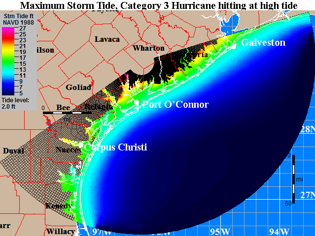 Figure 6. The maximum storm tide (storm surge plus an adjustment for hitting at high tide) expected from any Category 3 hurricane hitting anywhere along the coast of Texas at high tide. This so-called "MOM" (Maximum Of the Maximum Envelope Of Waters) is computed using NOAA's SLOSH storm surge model. The plot above IS NOT the expected storm tide everywhere along the coast from a hit by Hurricane Ike. The plot is the MAXIMUM high water for a worst-case scenario Category 3 hurricane moving at the worst possible angle at the worst possible forward speed. As such, this plot is the combination of SLOSH runs from over 50 different simulated hurricanes approaching the coast at different angles and different forward speeds. The maximums plotted here will only occur along a 20-mile stretch of the coast on the north side of Ike's eyewall. SLOSH model runs are advertised as being in error by plus or minus 20%. Image credit: NOAA. For storm surge evacuation zone information, consult the Texas Division of Emergency Management. I'll be posting a full set of storm surge maps for the Texas coast this afternoon. High tide along the Texas coast is Saturday morning at about 2am local time. Tidal range between low and high tide is about two feet. Elsewhere in the tropics There are no threat areas to discuss, and none of the reliable computer models are prediction tropical storm formation in the Atlantic over the next seven days. Today marks the halfway point of hurricane season, but I'm expecting that we've already seen about 2/3 of the action we're going to get this year. Links to follow Both GOES-East and GOES-West are operating in rapid scan mode, and you can see some pretty spectacular animations of Ike at Colorado State University's CIRA/RAMMB site. Tide gauges along the Gulf Coast Jeff Masters
Hurricane Ike
has taken advantage of the warm Gulf of Mexico waters it is over, and
has already built an eyewall. At 7:02 m EDT, the Hurricane Hunters
found a complete eyewall, which can also be seen on infrared satellite loops and Key West radar.
The infrared satellite imagery also shows a rapid cooling of the cloud
tops in Ike's eyewall and some of the spiral bands, indicating that the
thunderstorms are penetrating higher into the atmosphere--a sign of
strengthening. The latest data from a NOAA Hurricane Hunter aircraft
indicates that the pressure has begun to fall, but Ike's winds remain
at minimal hurricane force, 75 mph. All indications are that Ike will
intensify into a very dangerous major hurricane that will hit the Texas
coast Friday night or Saturday.
Figure 1. Current Key West radar image. Track forecast for Ike A trough of low pressure is currently passing to the north of Ike, and this trough has been able to turn Ike north of due west. Ike is now moving west-northwest, and this motion is expected to continue today. By Wednesday, Ike is expected to take a more westerly motion again, as high pressure to the north builds in. As Ike approaches Texas on Friday, a new trough of low pressure is expected to pass to the north, potentially turning Ike to the northwest. The latest 18Z (2pm EDT) computer models that have come in so far--the GFS, GFDL, and NOGAPS--point to a landfall near Corpus Christi. All of the major models foresee a landfall between Corpus Christi and Galveston. Landfall would occur late Friday night or early Saturday morning, and tropical storm force winds would arrive at the coast on Friday morning. Given the inability of the models to agree until now, this landfall is certainly not a "sure thing", and the cone of uncertainty covers the entire coast of Texas. Data from the NOAA jet will go into tonight's 00Z (8 pm EDT) model runs, which will be available first thing Wednesday morning. That set of model runs should give us a pretty good idea of where Ike will go. I'm sure emergency managers are not eager to call for an evacuation of Houston, after the debacle of the evacuation for Hurricane Rita in 2005. Over 110 people died in the evacuation--far more than died in the storm. Still, there is a significant chance that an evacuation of large stretches of the Texas coast--possibly including portions of Houston--will have to be ordered on Wednesday or Thursday.  Figure 2. The inside of Ike's eye, as photographed from a NOAA P-3 Hurricane Hunter aircraft on Sunday, September 7, 2008. Image credit: captcosmic. Intensity forecast for Ike Ike survived the passage of Cuba well, and remains a large and well-organized hurricane. Significant strengthening is ready to occur, now that Ike has built a new eyewall. I expect Ike will be a Category 2 or 3 hurricane by Wednesday night, and Ike has the potential to become a Category 4 hurricane by Thursday, as forecast by the HWRF and GFDL models. Water temperatures are a warm 29.5°C in the Gulf of Mexico, and wind shear is expected to be modest, 10-15 knots, for the remainder of Ike's life. Ike will be crossing over two regions of high heat content associated with the Loop Current and a Loop Current eddy (Figure 3). There is much higher oceanic heat content off the Texas coast than was present off the Louisiana coast for Gustav. Thus, it is more likely that Ike will be able to maintain major hurricane status as it approaches the coast. The GFDL model predicts landfall near Corpus Christi as a Category 3 hurricane Friday night. The SHIPS model is less aggressive, and foresees a strong Category 1 hurricane at landfall. Given the impressive appearance of Ike on satellite imagery, and the forecasts of high heat content and low shear along its path, I would be surprised if Ike hit as anything weaker than a Category 2 hurricane with 100 mph winds. Here's my rough probability break-down for Ike's strength at landfall, I forecast a 50% chance Ike will be a major hurricane at landfall: Category 1 or weaker: 20% Category 2: 30% Category 3: 30% Category 4 or 5: 20% Figure 3. Projected path of Ike overlaid on the current map of Tropical Cyclone Heat Potential (TCHP). TCHP is a measure of total ocean heat content, and TCHP values in excess of 80 kJ/cm^2 (yellow colors) are frequently associated with rapid intensification of hurricanes. Ike will be passing over two regions of high heat content--one associated with the Loop Current, and another associated with an eddy that broke off from the Loop Current in July. Note that heat content stays relatively high all the way to the coast of Texas, in contrast to what Gustav experienced as it approached the coast of Louisiana. Image credit: NOAA/AOML. Texas is highly vulnerable to storm surge The Texas coast is highly vulnerable to large storm surges, due to the long expanse of shallow Continental Shelf waters offshore. The shallow depths allow large the swirling winds of the hurricane to pile up huge mounds of water, which then sweep inland when the hurricane makes landfall. Even Category 1 hurricanes are capable of generating 15 foot storm surges along some sections of the Texas coast. For example, the August 29, 1942 hurricane hit near Port O'Connor, Texas as a Category 1 storm with 80 mph winds. However, this hurricane had been a Category 3 storm with 115 mph winds the day before landfall, allowing it to pile up a large storm surge over the Continental Shelf just offshore the central Texas coast. The storm weakened suddenly in the 12 hours before landfall, but brought a storm surge characteristic of a Category 2 or 3 hurricane to shore, since the high angular momentum of the swirling storm surge waters did not have time to decrease much. A 10-15 foot storm surge came ashore over a 100-mile stretch of coast between Port O'Connor and Freeport (Figure 4). Actually, looking at these storm surge values, I wouldn't be surprised if the 1942 storm was stronger both at landfall and before landfall than the official HURDAT database advertises. This storm came before the era of satellites and Hurricane Hunter aircraft. Figure 4. High water marks from the August 29, 1942 hurricane along the Texas coast. Image credit: "Characteristics of the Hurricane Storm Surge", by D. Lee Harris, U.S. Weather Bureau, 1963. A realistic worse-case scenario for Texas There is a significant chance that Ike will be the worst hurricane to hit Texas in over 40 years. The latest run of the HWRF and GFDL models paint a realistic worst-case scenario for Texas. These models bring Ike to the coast as a Category 4 hurricane (which I give a 20% probability of happening). The HWRF predicts a 170-mile stretch of coast will receive hurricane force winds of 74 mph or greater. A 100-mile stretch of coast will receive winds of Category 3 strength and higher, 115 mph. Hurricane force winds will push inland up to 50 miles, along a 50-mile wide region where the eyewall makes landfall. A 100-mile stretch of Texas coast will receive a storm surge of 10-15 feet, with bays just to the right of where the eye makes landfall receiving a 20-25 foot storm surge. This is what Hurricane Carla of 1961 did to Texas. Carla was a Category 4 hurricane with 145 mph winds at landfall, and drove a 10 foot or higher storm surge to a 180-mile stretch of Texas coast. A maximum storm surge of 22 feet was recorded at Port Lavaca, Texas. Despite the fact that the center of Carla hit over 120 miles southwest of Houston, the hurricane drove a 15-foot storm surge into the bays along the south side of the city. If you live in Texas, what are your chances of getting hit? I recommend Texas residents consult NHC's wind probability product to determine their odds of getting hurricane force winds. At present, NHC is calling for these odds of getting hurricane force winds at various Texas cities: Brownsville: 8% Corpus Christi: 8% Freeport: 10% Galveston: 9% Houston: 5% I think the odds are roughly double what NHC is advertising for the above cities. For storm surge evacuation zone information, consult the Texas Division of Emergency Management. I'll be posting some more detailed storm surge info Wednesday morning. Elsewhere in the tropics A area of disturbed weather near 10N, 21W, about 300 miles south of the Cape Verdes Islands, has changed little today. This morning's QuikSCAT pass showed a sloppy circulation and some 25 mph winds in heavy thunderstorms to the south. The region is currently under about 20 knots of shear, but shear is expected to decline over the disturbance as it moves west-northwest at 10-15 mph this week. No models currently predict development of this disturbance, but it is worth keeping an eye on. The disturbance will be near the northern Lesser Antilles Islands 7-8 days from now. Tonight, at 9pm EDT, I'll make my annual appearance on the Internet Partnership Radio program, "Center of Circulation". You can listen in at http://www.ipr365.com/. I'm usually on for at least 45 minutes. Jeff Masters
Hurricane Ike
has completed its final traverse of Cuba, and is now over the warm
waters of the Gulf of Mexico. All indications are that Ike will
intensify into a very dangerous major hurricane that will hit the Texas
coast Friday night or Saturday. Key West radar shows that the inner eyewall of Ike has collapsed, but satellite loops
show that Ike has maintained a large, well-organized circulation during
its passage of Cuba. The 4 pm EDT center fix from the Hurricane Hunters
found a central pressure of 968 mb, which is characteristic of a
Category 2 hurricane. Passage over Cuba did not disrupt the storm
enough to keep Ike from intensifying into a major hurricane over the
Gulf of Mexico.
The capital of Havana missed the worst of Ike, and reported highest sustained winds of just 40 mph, gusting to 58 mph, at 8 am this morning. Ike killed four people in Cuba yesterday--the first hurricane deaths in Cuba this year. Cuba put in place its usual massive evacuation plan for Ike, evacuating 1.2 million residents. Considering the number of people affected and the violence of Category 4 Gustav and Category 3 Ike, Cuba's low death toll this year is a remarkable achievement. Figure 1. Current Key West radar image. Track forecast for Ike A trough of low pressure is currently passing to the north of Ike, and this trough has been able to turn Ike north of due west. Ike is now moving west-northwest, and this motion is expected to continue today. By Wednesday, Ike is expected to take a more westerly motion again, as high pressure to the north builds in. As Ike approaches Texas on Friday, a new trough of low pressure is expected to pass to the north, potentially turning Ike to the northwest. The latest 12Z (8am EDT) computer models have come into much better agreement. All of the major models foresee a landfall between Corpus Christi and Galveston. Landfall would occur late Friday night or early Saturday morning, and tropical storm force winds would arrive at the coast on Friday morning. Given the inability of the models to agree until now, this landfall is certainly not a "sure thing", and the cone of uncertainty covers the entire coast of Texas. Data from the NOAA jet will go into tonight's 00Z (8 pm EDT) model runs, which will be available first thing Wednesday morning. That set of model runs should give us a pretty good idea of where Ike will go. I'm sure emergency managers are not eager to call for an evacuation of Houston, after the debacle of the evacuation for Hurricane Rita in 2005. Over 110 people died in the evacuation--far more than died in the storm. Still, there is a significant chance that an evacuation of large stretches of the Texas coast--including portions of Houston--will have to be ordered on Wednesday or Thursday. Figure 2. The inside of Ike's eye, as photographed from a NOAA P-3 Hurricane Hunter aircraft on Sunday, September 7, 2008. Image credit: captcosmic. Intensity forecast for Ike Ike survived the passage of Cuba well, and remains a large and well-organized hurricane. Significant strengthening will not occur until early Wednesday morning, since the storm has to build a new eyewall. Water temperatures are a warm 29.5°C in the Gulf of Mexico, and wind shear is expected to be modest, 10-15 knots. Ike will be crossing over two regions of high heat content associated with the Loop Current and a Loop Current eddy (Figure 3). The GFDL and HWRF models show Ike responding to these favorable conditions by intensifying to a Category 4 hurricane on Thursday. The wind shear for Friday has changed, and we are expecting wind shear to remain around 15 knots, which is still low enough to allow intensification. There is much higher oceanic heat content off the Texas coast than was present off the Louisiana coast for Gustav. Thus, it is more likely that Ike will be able to maintain major hurricane status as it approaches the coast. The GFDL and HWRF models predict landfall in southern Texas as a Category 4 hurricane Friday night. The SHIPS model is less aggressive, and foresees a Category 1 hurricane at landfall. Given the impressive appearance of Ike on satellite imagery, and the forecasts of high heat content and low shear along its path, I would be surprised if Ike hit as anything weaker than a Category 2 hurricane with 100 mph winds. Here's my rough probability break-down for Ike's strength at landfall, I forecast a 50% chance Ike will be a major hurricane at landfall: Category 1 or weaker: 20% Category 2: 30% Category 3: 30% Category 4 or 5: 20% Figure 3. Projected path of Ike overlaid on the current map of Tropical Cyclone Heat Potential (TCHP). TCHP is a measure of total ocean heat content, and TCHP values in excess of 80 kJ/cm^2 (yellow colors) are frequently associated with rapid intensification of hurricanes. Ike will be passing over two regions of high heat content--one associated with the Loop Current, and another associated with an eddy that broke off from the Loop Current in July. Note that heat content stays relatively high all the way to the coast of Texas, in contrast to what Gustav experienced as it approached the coast of Louisiana. Image credit: NOAA/AOML. Texas is highly vulnerable to storm surge The Texas coast is highly vulnerable to large storm surges, due to the long expanse of shallow Continental Shelf waters offshore. The shallow depths allow large the swirling winds of the hurricane to pile up huge mounds of water, which then sweep inland when the hurricane makes landfall. Even Category 1 hurricanes are capable of generating 15 foot storm surges along some sections of the Texas coast. For example, the August 29, 1942 hurricane hit near Port O'Connor, Texas as a Category 1 storm with 80 mph winds. However, this hurricane had been a Category 3 storm with 115 mph winds the day before landfall, allowing it to pile up a large storm surge over the Continental Shelf just offshore the central Texas coast. The storm weakened suddenly in the 12 hours before landfall, but brought a storm surge characteristic of a Category 2 or 3 hurricane to shore, since the high angular momentum of the swirling storm surge waters did not have time to decrease much. A 10-15 foot storm surge came ashore over a 100-mile stretch of coast between Port O'Connor and Freeport (Figure 4). Actually, looking at these storm surge values, I wouldn't be surprised if the 1942 storm was stronger both at landfall and before landfall than the official HURDAT database advertises. This storm came before the era of satellites and Hurricane Hunter aircraft. Figure 4. High water marks from the August 29, 1942 hurricane along the Texas coast. Image credit: "Characteristics of the Hurricane Storm Surge", by D. Lee Harris, U.S. Weather Bureau, 1963. A realistic worse-case scenario for Texas There is a significant chance that Ike will be the worst hurricane to hit Texas in over 40 years. The latest run of the HWRF and GFDL models paint a realistic worst-case scenario for Texas. These models bring Ike to the coast as a Category 4 hurricane (which I give a 20% probability of happening). The HWRF predicts a 170-mile stretch of coast will receive hurricane force winds of 74 mph or greater. A 100-mile stretch of coast will receive winds of Category 3 strength and higher, 115 mph. Hurricane force winds will push inland up to 50 miles, along a 50-mile wide region where the eyewall makes landfall. A 100-mile stretch of Texas coast will receive a storm surge of 10-15 feet, with bays just to the right of where the eye makes landfall receiving a 20-25 foot storm surge. This is what Hurricane Carla of 1961 did to Texas. Carla was a Category 4 hurricane with 145 mph winds at landfall, and drove a 10 foot or higher storm surge to a 180-mile stretch of Texas coast. A maximum storm surge of 22 feet was recorded at Port Lavaca, Texas. Despite the fact that the center of Carla hit over 120 miles southwest of Houston, the hurricane drove a 15-foot storm surge into the bays along the south side of the city. If you live in Texas, what are your chances of getting hit? I recommend Texas residents consult NHC's wind probability product to determine their odds of getting hurricane force winds. At present, NHC is calling for these odds of getting hurricane force winds at various Texas cities: Brownsville: 8% Corpus Christi: 8% Freeport: 10% Galveston: 9% Houston: 5% I think the odds are roughly double what NHC is advertising for the above cities. Elsewhere in the tropics A area of disturbed weather near 10N, 21W, about 300 miles south of the Cape Verdes Islands, has changed little today. This morning's QuikSCAT pass showed a sloppy circulation and some 25 mph winds in heavy thunderstorms to the south. The region is currently under about 20 knots of shear, but shear is expected to decline over the disturbance as it moves west-northwest at 10-15 mph this week. No models currently predict development of this disturbance, but it is worth keeping an eye on. The disturbance will be near the northern Lesser Antilles Islands 7-8 days from now. The remains of Tropical Storm Josephine are no longer a threat. The tragedy in Haiti The death toll in Haiti due to the onslaught of Hurricanes Gustav, Hanna, and Ike, plus Tropical Storm Fay, is now over 1,000 people. At least 14,000 homes have been destroyed, and 800,000 people are without food, water, and/or shelter. The death toll is sure to rise higher as rescuers reach more remote flooded areas in coming days. The economic impact of the disaster is projected to be greater than the 2004 devastation wrought by Hurricane Jeanne, which killed over 2,000 people. Haiti needs all the help it can get, and I want to thank everyone who has donated to the Lambi Fund of Haiti charity. They're an outstanding group that I've supported for a number of years, and they focus on fixing the underlying causes of poverty and natural disasters in Haiti.  Figure 5. The flooded city of Gonaives after Hurricane Hanna, September 3, 2008. Image credit: Lambi Fund of Haiti. Tonight, at 9pm EDT, I'll make my annual appearance on the Internet Partnership Radio program, "Center of Circulation". You can listen in at http://www.ipr365.com/. I'm usually on for at least 45 minutes. I'll have an update tonight by 9pm EDT, with the latest model runs for Ike, and more storm surge info for Texas. Jeff Masters
Hurricane Ike
has made landfall over the western tip of Cuba, and continues its
onslaught on that island nation with 80 mph winds, a 4-7 foot storm
surge, and heavy rains of 6-12 inches. Key West radar
shows that Ike has a tiny 10-mile wide eye, and Ike has hurricane force
winds over just a small region near its center. In fact, the 8 am
Hurricane Hunter flight was only able to find winds of tropical storm
strength, and Ike may be weaker than advertised. Still, the storm has a
central pressure of 965 mb, which is a pressure more typical of
Category 2 hurricanes.
The capital of Havana reported sustained winds of 40 mph gusting to 58 mph this morning, and the worst of Ike's winds will pass well south of the city. Ike's primary threat to Cuba at this point is heavy rains. Ike killed four people in Cuba yesterday--the first hurricane deaths in Cuba this year. Cuba put in place its usual massive evacuation plan for Ike, evacuating 1.2 million residents. Considering the number of people affected and the violence of Category 4 Gustav and Category 3 Ike, Cuba's low death toll this year is a remarkable achievement. Figure 1. Current Key West radar image. Track forecast for Ike A trough of low pressure is currently passing to the north of Ike, and this trough has been able to turn Ike north of due west. Ike is now moving west-northwest, and this motion is expected to continue today, taking the storm across the western tip of Cuba, where Hurricane Gustav crossed just two weeks ago. By Wednesday, Ike is expected to take a more westerly motion again, as high pressure to the north builds in. As Ike approaches Texas on Friday, a new trough of low pressure is expected to pass to the north, potentially turning Ike to the northwest. The latest 0Z/6Z (8 pm/2 am EDT) computer models show a variety of timings and strengths for Friday's low pressure trough, resulting in a high amount of uncertainty on where Ike will make landfall. Most of the models predict the trough will arrive too late and be too weak to affect Ike, and take Ike ashore near the Texas/Mexico border. These models include the NOGAPS, GFS, and GFDL. The HWRF is bit farther north, placing landfall near Corpus Christi, and the UKMET and ECMWF are farther north still, targeting a region between Freeport and Galveston. Oddly, these two farthest north models were the southernmost ones yesterday. Suffice to say, the crystal ball is still cloudy. The entire Texas and northernmost coast of Mexico are at risk from Ike. Intensity forecast for Ike While Ike is over Cuba, slow weakening will occur. Significant strengthening will not occur until Wednesday morning, after the storm has recovered from its crossing of Cuba. Water temperatures are a warm 29.5°C in the Gulf of Mexico, and wind shear is expected to be modest, 10-15 knots. Ike will be crossing over two regions of high heat content associated with the Loop Current and a Loop Current eddy (Figure 2). The GFDL and HWRF models show Ike responding to these favorable conditions by intensifying to a Category 4 hurricane on Thursday. By Friday, wind shear is predicted to increase to 15-20 knots, but the heat content of the ocean remains relatively high. There is much higher oceanic heat content off the Texas coast than was present off the Louisiana coast for Gustav. Thus, it is less likely that Ike will significantly weaken as it approaches the coast. The GFDL and HWRF models predict landfall in southern Texas as a Category 3 or 4 hurricane Friday night. The SHIPS model is less aggressive, and foresees a Category 1 or 2 hurricane at landfall. So take your pick--Ike could be a Category 1, 2, 3, or 4 hurricane at landfall. Such is the state of long-range hurricane intensity forecasts. A middle of the road forecast of a Category 2 or 3 hurricane at landfall is a reasonable one at present. Figure 2. Projected path of Ike overlaid on the current map of Tropical Cyclone Heat Potential (TCHP). TCHP is a measure of total ocean heat content, and TCHP values in excess of 80 kJ/cm^2 (yellow colors) are frequently associated with rapid intensification of hurricanes. Ike will be passing over two regions of high heat content--one associated with the Loop Current, and another associated with an eddy that broke off from the Loop Current in July. Note that heat content stays relatively high all the way to the coast of Texas, in contrast to what Gustav experienced as it approached the coast of Louisiana. Image credit: NOAA/AOML. Elsewhere in the tropics A area of disturbed weather has developed near 10N, 21W, about 300 miles south of the Cape Verdes Islands. This morning's QuikSCAT pass showed a sloppy circulation and some 25 mph winds in heavy thunderstorms to the south. The region is currently under about 20 knots of shear, but shear is expected to decline over the disturbance as it moves west-northwest at 10-15 mph this week. The GFS model predicts this disturbance could develop by Sunday. The disturbance will be near the northern Lesser Antilles Islands 7-8 days from now. The remains of Tropical Storm Josephine are no longer a threat. The tragedy in Haiti The death toll in Haiti due to the onslaught of Hurricanes Gustav, Hanna, and Ike, plus Tropical Storm Fay, is now over 1,000 people. At least 14,000 homes have been destroyed, and 800,000 people are without food, water, and/or shelter. The death toll is sure to rise higher as rescuers reach more remote flooded areas in coming days. The economic impact of the disaster is projected to be greater than the 2004 devastation wrought by Hurricane Jeanne, which killed over 2,000 people. Haiti needs all the help it can get, and I want to thank everyone who has donated to the Lambi Fund of Haiti charity. They're an outstanding group that I've supported for a number of years, and they focus on fixing the underlying causes of poverty and natural disasters in Haiti. Figure 3. The flooded city of Gonaives after Hurricane Hanna, September 3, 2008. Image credit: Lambi Fund of Haiti. Tonight, at 9pm EDT, I'll make my annual appearance on the Internet Partnership Radio program, "Center of Circulation". You can listen in at http://www.ipr365.com/. I'm usually on for at least 45 minutes. I'll have an update this afternoon. Jeff Masters
Cuba continues to take a pounding from Hurricane Ike,
which smashed ashore in eastern Cuba last night as a Category 3
hurricane with 120 mph winds. Ike's winds have since weakened to
borderline tropical storm/Category 1 strength, according to the latest
data from the Hurricane Hunters. At 2 pm EDT, an Air Force Hurricane
Hunter aircraft found top surface winds of 65-70 mph--just below
hurricane force. At 2 pm CDT, Jucaro, Cuba on the south coast of the island reported sustained winds of 49 mph.
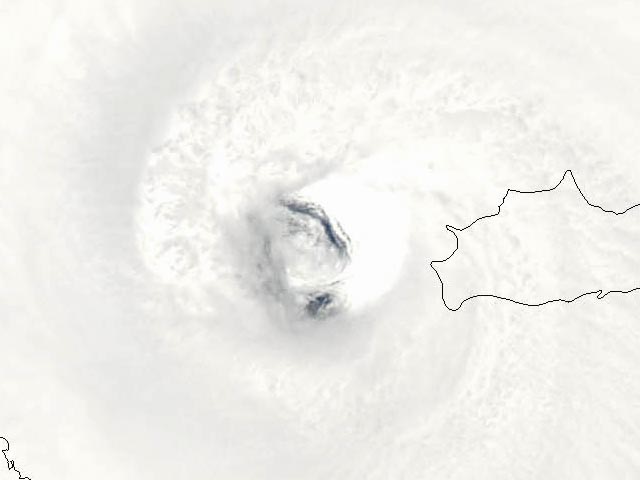 Figure 1. NASA MODIS satellite image of Hurricane Ike's eye at 1 pm EDT Sunday 9/7/08. Ike had just crossed Great Inagua Island (right) as a Category 4 hurricane with 135 mph winds. Damage was extreme on the island, as well as nearby Grand Turk Island, but no deaths or injuries were reported. Image credit: NASA Earth Observatory. Track forecast for Ike Ike's center moved out over the warm western Caribbean waters late this morning, and is now tracking west to west-northwest, closely hugging the south coast of Cuba. Ike is expected to track west-northwest on Tuesday into the Gulf of Mexico, passing near or over Havana, Cuba. The expected track could bring tropical storm force winds of 40-50 mph to Key West and the Lower Keys on Tuesday afternoon. The latest 12Z (8 am EDT) computer models continue to show that Ike will track northwest into the central Gulf of Mexico on Tuesday and Wednesday. However, there has been a major shift in the model tracks for Thursday and Friday. All of the models are calling for a more westward motion, bringing Ike to a landfall in Texas sometime Friday afternoon through Saturday morning. The new set of model runs is portraying stronger high pressure over the central Gulf on Wednesday and Thursday will push Ike faster than expected to the west. The trough of low pressure expected to turn Ike to the north does not arrive until Friday night, after the storm has already made landfall in Texas. The timing and strength of this trough, plus the speed with which Ike moves across the Gulf this week are still uncertain. We cannot be confident yet of a Texas landfall until we see several model runs in row that lock in on this solution. All five major models--the GFS, UKMET, GFDL, HWRF, and ECMWF--foresee a landfall between Corpus Christi and Port Arthur. The GFDL model foresees landfall as a Category 2, and the HWRF as a Category 3. Landfall could be as early as Friday afternoon, or as late as Saturday morning. Intensity forecast for Ike Although Ike is currently over some very warm waters, the eye is very close to the coast. This proximity to land will inhibit intensification. Furthermore, the Hurricane Hunters reported at 2 pm EDT that Ike had concentric eyewalls--an inner eyewall of 17 miles in diameter, and an outer eyewall of 70 miles in diameter. Hurricanes in this configuration cannot intensify significantly until the inner eyewall collapses, and the outer eyewall takes over. This process typically takes a day, and Ike will be back over Cuba before this "Eyewall Replacement Cycle" (ERC) has had time to complete. I expect that Ike will intensify by at most 10 mph while it is over water south of Cuba. This is good news for Havana, which should only get a strong tropical storm or weak Category 1 hurricane on Tuesday morning. Ike should emerge into the Gulf of Mexico Tuesday relatively intact. It will take the storm a day or two to reorganize once over the Gulf, where wind shear is expected to be light (<10 knots) and water temperatures will be warm, near 30°C. Ike should be able to intensify into a Category 3 or 4 hurricane by Thursday, as forecast by the GFDL and HWRF models. Once Ike approaches the coast on Friday, the total heat content of the ocean declines, and the shear is forecast to rise to a moderate 15-20 knots. The GFDL and HWRF models respond by weakening Ike to a Category 2 or 3 hurricane at landfall in Texas. This is a reasonable forecast, but our skill in forecasting intensity is low, and Ike could just as easily be a Category 1 or Category 4 hurricane at landfall. Watching the remains of Josephine The remains of Tropical Storm Josephine are near 19N, 46W, in the middle Atlantic Ocean, and have grown less organized today. The storm still has some spin, but it slowly losing it. A large area of dry Saharan air surrounds the system, and Josephine currently has no heavy thunderstorm activity. This will be my last mention of it, since it appears to be dissipating. The tragedy in Haiti The death toll in Haiti due to the onslaught of Hurricanes Gustav, Hanna, and Ike, plus Tropical Storm Fay, grew to at least 630 today, as more victims of Hurricane Hanna were identified. Rains from Hurricane Ike have killed at least 61 people, and the death toll is sure to rise higher as rescuers reach more remote flooded areas in coming days. Haiti needs all the help it can get, and I want to thank all of you who donated to the Lambi Fund of Haiti charity I recommended yesterday. I've heard from the administrators of the charity that several hundred of you have made on-line donations. Wow! Heartfelt thanks! 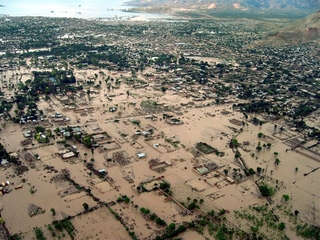 Figure 2. The flooded city of Gonaives after Hurricane Hanna, September 3, 2008. Image credit: Lambi Fund of Haiti. I'll have an update Tuesday morning. Jeff Masters
Cuba is taking a terrible beating from Hurricane Ike,
which crashed ashore in eastern Cuba last night as a Category 3
hurricane with 120 mph winds. Ike's winds have since weakened to
Category 2 strength--100 mph--but are still strong enough to destroy
the Cuba's electrical system and heavily damage the cities it
encounters along the heavily populated east-central portion of the
country. Damage will be heavy in Camaguey,
which reported sustained winds of 49 mph at 8am EDT as Ike passed 20
miles to the south. Baracoa, on the coast to the southeast of where Ike
made landfall, suffered a significant storm surge, topped by high
battering waves, that damaged or destroyed 1,000 buildings. Ike's winds
and rains of 6-12 inches will cause additional heavy losses to Cuban
agriculture, and the storm should easily rank as one of the top-five
most damaging storms in Cuban history. Ike is expected to track over
Havana Tuesday morning, and the city's 2.2 million people can expect
significant damage to the many poorly-built structures in the capital
city. It will take Cuba a long time to recover from Ike.
On Sunday, Ike dumped heavy rain on northern Haiti, triggering floods that killed at least 73 people. Haiti has been battered by Fay, Gustav, Hanna, and Ike this year, and the death toll has grown to over 300. This makes 2008 Haiti's worst hurricane season since 2004, when Hurricane Jeanne's rains triggered flooding that killed at least 2,000 people in the northern city of Gonaives. Additional rains of 3-5 inches from Ike's outermost spiral bands are likely today over Haiti. The southeast Bahamas were also hard-hit by Ike. Media reports out of Grand Turk Island and Great Inagua Island indicate that over 90% of all buildings on those islands were damaged or destroyed by Ike's wind and storm surge. 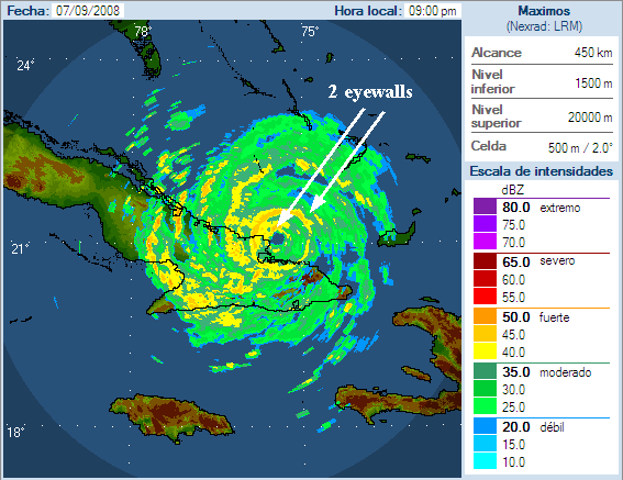 Figure 1. Radar image of Ike at landfall in Cuba at 9 pm EDT Sun 9/07/08. At the time of landfall, Ike had two concentric eyewalls. The outer eyewall had a diameter of 55 miles, spreading out Ike's damaging winds over a large region of Cuba. Image credit: Instituto de Meteorologia de la Republica de Cuba. Track forecast for Ike The Florida Keys are probably off the hook. It now looks unlikely that Ike will bring hurricane force winds to the Keys. Ike continues to move due west, and the eye may pop out to the south of Cuba at times between now and Tuesday morning. It is unlikely that the eye will move far enough from the coast for significant strengthening to occur, though. Passage over Cuba has disrupted the eyewall enough that it would take at least 12 hours over water for the storm to reorganize, and Ike probably won't get that kind of time over water. Ike is expected to track west-northwest on Tuesday into the Gulf of Mexico, passing near or over Havana, Cuba. The expected track should bring tropical storm force winds of 50-70 mph to Key West and the Lower Keys on Tuesday afternoon. The latest 06Z (2 am EDT) computer models no longer expect a turn northward towards the Florida Panhandle. As we've seen many times this hurricane season, the models were over-enthusiastic about the intensity of a trough of low pressure passing to the north. High pressure has been dominant over the eastern U.S. the past month, and the models have consistently been underpredicting the dominance of this high pressure. The current steering pattern, with high pressure entrenched over the eastern U.S., steering hurricanes into Florida and the Gulf Coast, is similar to the steering pattern of 2004 and 2005. This steering pattern has acted to steer six straight storms into the U.S., and is not expected to change significantly over the next two weeks, according to the latest long-range forecasts from the GFS model. As Ike moves approaches within 300 miles of the Louisiana coast on Friday, there will be another trough of low pressure capable of turning the storm to the north. The GFS, GFDL, HWRF, NOGAPS, and Canadian models all predict that this trough will be strong enough to turn Ike northwards into central or western Louisiana. The UKMET and ECMWF models disagree, and think high pressure will dominate enough to force Ike westwards into Texas, between Corpus Christi and the Louisiana border. These two models have been trending too far south with Ike so far, so I would lean towards a landfall in western Louisiana at this point. Intensity forecast for Ike Ike will probably be a tropical storm or Category 1 hurricane on Tuesday afternoon when it emerges into the Gulf of Mexico. It will take the storm a day or two to reorganize. Wind shear is expected to be light (<10 knots) and water temperatures will be high, near 30°C, so Ike will probably intensify into a Category 3 hurricane by Thursday. Once Ike approaches the coast on Friday and Saturday, the total heat content of the ocean declines, and the shear is forecast to rise to a moderate 15-20 knots. The GFDL and HWRF models respond by weakening Ike to a Category 1 or 2 hurricane at landfall in western Louisiana. This is a reasonable forecast, but our skill in predicting intensity changes this far in advance is poor. Links to follow: Holguin, Cuba radar Watching the remains of Josephine The remains of Tropical Storm Josephine are near 19N, 45W, in the middle Atlantic Ocean, headed west towards the northern Lesser Antilles Islands. The storm still has some spin, and wind shear has fallen below 10 knots today. However, a large area of dry Saharan air surrounds the system, and Josephine currently has no heavy thunderstorm activity. Shear is expected to remain low the next four days, and Josephine will find itself in a moister environment 2-4 days from now. These conditions may allow Josephine to regenerate later this week. The NOGAPS and UKMET models predicts this may happen by Thursday, when the storm would be about 200 miles north of Puerto Rico. NHC is currently giving Josephine a low (<20%) chance of regenerating by Wednesday. These odds will probably rise during future Tropical Weather Outlooks, assuming Josephine can maintain its spin. The tragedy in Haiti I heard from one of the leaders of the Lambi Fund of Haiti charity yesterday. It seems she noticed a sharp increase on-line donations after I recommended their charity as a way to help out the people in Haiti. Thanks to all of you who contributed! Figure 2. The flooded city of Gonaives after Hurricane Hanna, September 3, 2008. Image credit: Lambi Fund of Haiti. I'll have an update this afternoon. Jeff Masters
Hurricane Ike
is headed to eastern Cuba after blasting Grand Inagua Island in the
southeast Bahama Islands this morning. Hurricane Hunter observations, Cuban radar, and satellite loops
continue to show a that Ike remains a large and dangerous major
hurricane with 120 mph winds. The latest 2:15 pm EDT center fix found a
central pressure of 950 mb, up 1 mb from the 7:07 am EDT center fix.
Microwave imagery (Figure 1) suggests that Ike has formed a second
eyewall, concentric with its inner eyewall, and this is limiting the
intensification at present. The down side of this development is that
it spreads out Ike's strongest winds over a larger area, and a longer
stretch of the Cuban coast will receive damaging winds.
Ike has brought heavy rain to northern Haiti, with rain rates of up to one inch per hour estimated in the mountains north of the flood-ravaged city of Gonaives (Figure 2). These torrential rains have also been affecting the southeast Bahamas and Cuba. Ike will be a devastating blow for Cuba, as the storm will be hitting one of the most heavily populated regions of the country. 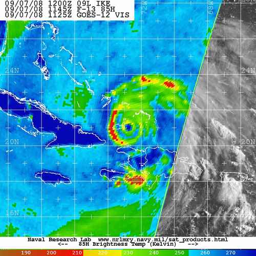 Figure 1. Microwave image from 7:45 am EDT Sun 9/7/08. Image shows Ike had two concentric eyewalls. Image credit: Navy Research Lab, Monterey. 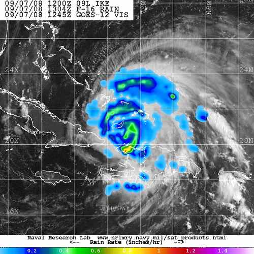 Figure 2. Estimated precipitation from Hurricane Ike at 9:04 am EDT Sun 9/7/08. Image credit: Navy Research Lab, Monterey. Track forecast for Ike Ike continues to move due west. A turn to the west-northwest is expected Monday. The latest 12Z (8 am EDT) computer models have not changed much from the previous set of runs. Ike is expected to track inland along the spine of Cuba for a day or longer. Along this track, Ike would likely weaken to a Category 2 or even a Category 1 hurricane. However, it would take only a very small deviation from the forecast track for Ike to spend much less time over Cuba and primarily track over the warm waters of the Florida Straits instead. None of the models are currently predicting this, but hurricane are unpredictable. I give it a 20% chance that Ike will defy the current forecast and arrive at the Keys as a major hurricane of Category 3 or 4 strength because of an unexpected wobble to the north. The SHIPS intensity model predicts Ike will be a Category 4 hurricane with 135 mph winds if this happens. The Lower Keys including Key West would be at greatest risk, and a maximum storm tide of 9-10 feet (Figure 2) could be expected in the Lower Keys in this scenario (storm tide is storm surge plus an adjustment in case Ike hits at high tide). I strongly encourage Keys residents to pay heed to the mandatory evacuation order and leave today. If Ike does spend the expected 24-36 hours over Cuba, only tropical storm or Category 1 force winds are likely in the Keys, though. 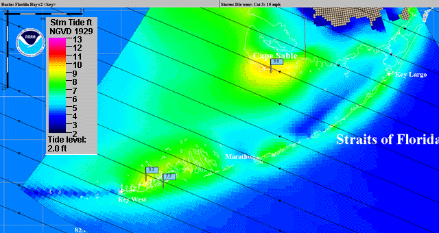 Figure 2. Expected maximum storm tide (storm surge plus adjustment for hitting at high tide) from a Category 3 hurricane moving WNW at 15 mph through the Florida Keys, hitting at high tide. This plot is an ensemble of many different hurricane tracks (shown as black lines), not just one hurricane. The maximum surge from the ensemble is plotted here. The model used is NOAA's SLOSH model. Note that oceanside surge is a foot to two feet lower than bay-side surge. Bay-side surge comes well after the storm center has passed the Keys, from the westerly winds behind the storm. Too many people have been harmed because they thought it was safe to go near the water on the bay side just after a storm has passed. Image credit: Dr. Stephen Baig, NOAA (retired). Once Ike emerges into the Gulf of Mexico on Tuesday, a weak trough of low pressure passing to the north may be able to induce a more north-northwesterly motion to Ike, and pull it towards the Florida Panhandle, bringing tropical storm force winds to Tampa on Wednesday. The HWRF and NOGAPS models predict this, though the HWRF takes Ike further from Florida than in its previous run. The rest of the models push Ike more to the west, into the central Gulf of Mexico. The eventual landfall locations predicted by the models range from the Florida Panhandle to the South Texas coast. It is too early to guess where Ike will go at this point, since landfall is probably about 6 days away. Intensity forecast for Ike Ike has remained at constant intensity today, and no major changes are expected before landfall in Cuba tonight. Sea surface temperatures (SSTs) have warmed to 29.5°C underneath Ike and will warm to 30.0°C over the Gulf of Mexico. Shear has dropped below 10 knots and is expected to remain below 10 knots for the next four days. As long as Ike is not over Cuba, it has favorable conditions for intensification. Once Ike passes Cuba and enters the Gulf of Mexico, the intensification potential remains high, as shear is predicted to be below 15 knots, and the waters are hot. Links to follow: Holguin, Cuba radar Punta De Maisi, Cuba weather Punta Lucrecia, Cuba weather Elsewhere in the tropics The remains of Tropical Storm Josephine are near 18N, 42W, in the middle Atlantic Ocean, headed west towards the northern Lesser Antilles Islands. The storm still has some spin, but wind shear of 20 knots is preventing re-development. Wind shear is predicted to fall below 10 knots on Monday night and remain below 10 knots for several days thereafter. This may allow Josephine to regenerate later this week. The NOGAPS model predicts this will happen by Thursday, when the storm would be about 200 miles north of Puerto Rico. NHC is currently giving Josephine a low (<20%) chance of regenerating by Tuesday. These odds will probably rise by tomorrow afternoon. The tragedy in Haiti As Ike pounds Haiti with torrential rains today, it is clear that Haiti will need massive assistance to recover from this latest disaster. If you're looking to contribute to the cause, I recommend the Lambi Fund of Haiti charity. I've been a contributor for a number of years, and have been impressed with their leadership and aims. The charity seeks not just to provide much needed temporary food aid, but to make investments in sustainable development in an effort to restore environmental integrity and reduce poverty. One of the main places my donations have gone is to fund the purchase and planting of thousands of trees on Haiti's denuded mountainsides. These treeless slopes, missing more than 98% of their original forest cover, allow flood waters from hurricanes to rush down and cause the mind-numbing loss of life we've grown to expect with each hurricane that affects Haiti. If you're looking to help out in the country in the Western Hemisphere that needs the most help, consider a donation to the Lambi Fund. Figure 4. The flooded city of Gonaives after Hurricane Hanna, September 3, 2008. Image credit: Lambi Fund of Haiti. If there's an important change in the forecast for Ike, I'll have an update tonight by 9 m EDT. Otherwise, expect a new update Monday morning. Jeff Masters
Hurricane Ike
is blasting Grand Inagua Island with Category 4 fury, as the storm
heads towards eastern Cuba. Earlier this morning, a wunderground
personal weather station in Providentiales
in the Turks and Caicos Islands recorded sustained winds of 66 mph
before failing. NHC reported another station closer to the eye of Ike
had sustained winds of 115 mph. Damage will be extremely heavy on Great
Inagua island today, which may receive a storm surge in excess of 13
feet. The latest satellite imagery and Hurricane Hunter data show
little change to Ike, which remains a powerful Category 4 hurricane
with 135 mph winds and extremely heavy rains. Recent microwave imagery
(Figure 1) indicates Ike is lashing Haiti with heavy rains of up to 1/2
inch per hour. These heavy rains will cause deadly floods in the
already hurricane-ravaged nation.
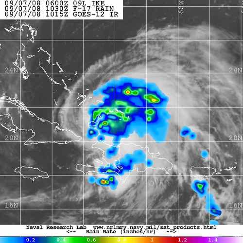 Figure 1. Estimated precipitation from Hurricane Ike. Image credit: Navy Research Lab, Monterey. Track forecast for Ike Ike has stopped moving west-southwest, and is now moving due west. A turn to the west-northwest is expected Monday. The latest 06Z (2 am EDT) computer models have shifted slightly north, but still predict Ike will track inland along the spine of Cuba for a day or longer. Along this track, Ike would likely weaken to a Category 2 or even a Category 1 hurricane. However, it would take only a very small deviation from the forecast track for Ike to spend much less time over Cuba and primarily track over the warm waters of the Florida Straits instead. While none of the models are currently predicting this, I give it a 30% chance that Ike will arrive at the Keys as a major hurricane of Category 3 or 4 strength because of an unexpected wobble to the north. The SHIPS intensity model predicts Ike will be a Category 4 hurricane with 135 mph winds if this happens. The Lower Keys including Key West are at greatest risk, and a maximum storm tide of 9-10 feet (Figure 2) can be expected in the Lower Keys in this scenario (storm tide is storm surge plus an adjustment in case Ike hits at high tide). I strongly encourage Keys residents to pay heed to the mandatory evacuation order and leave today. Ike could easily be much worse than Wilma was. If Ike does spend the expected 24-36 hours over Cuba, only tropical storm or Category 1 force winds are likely in the Keys. Figure 2. Expected maximum storm tide (storm surge plus adjustment for hitting at high tide) from a Category 3 hurricane moving WNW at 15 mph through the Florida Keys, hitting at high tide. This plot is an ensemble of many different hurricane tracks (shown as black lines), not just one hurricane. The maximum surge from the ensemble is plotted here. The model used is NOAA's SLOSH model. Note that oceanside surge is a foot to two feet lower than bay-side surge. Bay-side surge comes well after the storm center has passed the Keys, from the westerly winds behind the storm. Too many people have been harmed because they thought it was safe to go near the water on the bay side just after a storm has passed. Image credit: Dr. Stephen Baig, NOAA (retired). Once Ike emerges into the Gulf of Mexico on Tuesday, a trough of low pressure passing to the north may be able to induce a more north-northwesterly to Ike, and pull it towards the Florida Panhandle, bringing tropical storm force winds to Tampa on Wednesday. The HWRF is the only model showing this, and the rest of the models push Ike more to the west, into the central Gulf of Mexico. The eventual landfall locations predicted by the models range from Alabama to the Mexican border. It is too early to have a feel for where Ike will go at this point, since landfall is probably 6-7 days form now. Intensity forecast for Ike Sea surface temperatures (SSTs) have warmed to 29.5°C underneath Ike and will warm to 30.0°C over the Gulf of Mexico. Shear has dropped below 10 knots and is expected to remain below 10 knots for the next four days. As long as Ike is not over Cuba, it has very favorable conditions for intensification. Once Ike passes Cuba and enters the Gulf of Mexico, the intensification potential remains high, as shear is predicted to be below 15 knots, and the waters are hot. Links to follow: Holguin, Cuba radar Punta De Maisi, Cuba weather Punta Lucrecia, Cuba weather Paying homage at the Key West Hurricane Grotto If you live in Key West, I highly recommend a visit to the Hurricane Grotto to ask for some divine intervention in regards to Ike. There's a church in Key West called the St. Mary's Star of the Sea Roman Catholic Church. In 1922, a nun built a "hurricane grotto" on the grounds of the church in memory of the 600 who died during the great Atlantic-Gulf hurricane of Sept. 10, 1919, a Category 4 hurricane that made a direct hit on Key West. The nun vowed that as long as the grotto stood, Key West would not suffer the brunt of another hurricane. Key West residents regularly make pilgrimages to the grotto to pray for protection from hurricanes. And so far, the grotto has worked--no Key West resident has died from a hurricane strike since the 1919 hurricane.  Figure 3. Key West's famous Hurricane Grotto. Image credit: Cayogal. As Hurricane Rita approached Key West in September of 2005, it was apparent that the magic of the Grotto would be severely tested. As I wrote in a blog the day after Rita passed: Well, the protection of the grotto worked again. Key West barely escaped the brunt of a severe hurricane that could have been so very much worse. Had Rita's intensification cycle started 24 hours earlier, and she tracked 50 miles further north, the city of Key West would have been devastated. The Key West airport never measured sustained hurricane force winds from Rita, although the National Hurricane Center did receive an unofficial report of sustained winds of 75 mph with gusts to 102 mph in the Key West area. There was flooding and wind damage that will no doubt add up to tens of millions of dollars, but Key West is feeling lucky tonight. Key Westers, pay a visit to your grotto tomorrow and give thanks! The tragedy in Haiti As Ike pounds Haiti with torrential rains today, it is clear that Haiti will need massive assistance to recover from this latest disaster. If you're looking to contribute to the cause, I recommend the Lambi Fund of Haiti charity. I've been a contributor for a number of years, and have been impressed with their leadership and aims. The charity seeks not just to provide much needed temporary food aid, but to make investments in sustainable development in an effort to restore environmental integrity and reduce poverty. One of the main places my donations have gone is to fund the purchase and planting of thousands of trees on Haiti's denuded mountainsides. These treeless slopes, missing more than 98% of their original forest cover, allow flood waters from hurricanes to rush down and cause the mind-numbing loss of life we've grown to expect with each hurricane that affects Haiti. If you're looking to help out in the country in the Western Hemisphere that needs the most help, consider a donation to the Lambi Fund. Figure 4. The flooded city of Gonaives after Hurricane Hanna, September 3, 2008. Image credit: Lambi Fund of Haiti. I'll have an update between 4-5pm EDT today. Jeff Masters
The latest set of 18Z (2 pm EDT) computer models
are in, and there is little change from the previous forecasts for days
1-4. All of the models continue to indicate Ike will pass through the
Southeastern Bahamas and hit the north coast of Cuba. On day five and
beyond, there is shift to the west in Ike's track by most of the
models, taking the storm further from Florida into the central Gulf of
Mexico. I've pasted in relevant portions of my previous 5 pm blog
below, unchanged.
Jeff Masters Previous blog from 5 pm Hurricane Ike has re-intensified, and now has Category 4-strength winds, according to the latest data from the Hurricane Hunters. Both an Air Force and a NOAA aircraft recorded surface winds of 135 mph this afternoon on the northeast side of Ike. Category 4 strength winds range from 135-155 mph. Infrared satellite loops show Ike is more symmetric now, with improved upper-level outflow to the north. Shear has fallen from 25 knots this morning to 15 knots this afternoon, allowing this intensification to occur. All of the major models agree that Ike will hit eastern Cuba on Sunday night. After this point, the models continue to diverge. A southern camp of models, the ECMWF and UKMET, take Ike across eastern Cuba and into the western Caribbean, then across the western tip of Cuba or Yucatan Channel between Cuba and Mexico's Yucatan Peninsula. These models predict an eventual landfall near the Mexico/Texas border a week from now. This track would bring tropical storm conditions to the Cancun/Cozumel area beginning Tuesday afternoon or evening, with possible hurricane conditions by Wednesday morning. The northern camp of models, including the GFS, NOGAPS, GFDL, and HWRF, turn Ike west-northwest over Cuba, forecasting that Ike will pop off the coast of Cuba near the Florida Keys on Tuesday, then swing north-northwest. The northward turn is delayed in the current runs, putting Ike into the central Gulf of Mexico, or several hundred miles offshore the western Florida coast. The trough of pressure that pulls Ike to the north is expected to be weak, leaving Ike in a region of weak steering currents. A similar situation occurred in 1985, when Category 3 Hurricane Elena got stranded in the Gulf and wander offshore of the Florida Panhandle for several days. So far, the GFDL has done a good job with Ike, so I will continue to lean towards that track. The GFDL tracks Ike over Cuba until the storm pops off the coast south of the Keys, and intensifies it from a borderline Category 1 or 2 hurricane to a Category 3 hurricane as it passes 50 miles southwest of Key West. The GFDL brings Category 2 winds to Key West. The model then takes Ike north-northwestward into the Gulf of Mexico to an uncertain future. Figure 1. Expected maximum storm tide (storm surge plus adjustment for hitting at high tide) from a Category 3 hurricane moving WNW at 15 mph through the Florida Keys, hitting at high tide. This plot is an ensemble of many different hurricane tracks (shown as black lines), not just one hurricane. The maximum surge from the ensemble is plotted here. The model used is NOAA's SLOSH model. Note that ocean side surge is a foot to two feet lower than bay-side surge. Bay-side surge comes well after the storm center has passed the Keys, from the westerly winds behind the storm. Too many people have been harmed because they thought it was safe to go near the water on the bay side just after a storm has passed. Image credit: Dr. Stephen Baig, NOAA (retired). Florida Keys are at high risk from Ike The danger to the Keys has diminished some, thanks to the continued west-southwest motion of Ike, and the consensus model tracks taking Ike over Cuba or just south of it for a long distance. The Keys are in a Category 2 or 3 evacuation zone, and will be inundated by a direct hit from a Category 2 or 3 hurricane. It's now looking unlikely that Ike will pass through the Keys as a Category 4 hurricane. Category 3 conditions are possible in Key West and the Lower Keys, which would likely bring a maximum storm tide (storm surge plus an adjustment in case the hurricane hits at high tide) of 5-9 feet. Category 1 or 2 conditions are more likely in the Keys, though. I believe there is a 40% chance Ike will bring Category 1 strength winds or higher to Key West and the Lower Keys. The NHC Wind Probability Product forecast gives Key West a 17% chance of receiving hurricane force winds from Ike. Intensity forecast for Ike Sea surface temperatures (SSTs) have warmed to 29.5°C underneath Ike and will warm to 30.0°C over the Gulf of Mexico. Shear has dropped from 25 knots this morning to 15 knots this afternoon, and is forecast to drop below 10 knots tonight. Ike should continue intensifying until the eye contracts to point where it is unstable. The eyewall will collapse, and a new eyewall will form at a much larger radius from the center than before. This process is common in intense hurricanes, and is called an Eyewall Replacement Cycle (ERC). Landfall on Cuba will significantly disrupt the storm, and Ike's strength as it passes the Keys is difficult to guess at this point. The most likely strength is a Category 1, but it could easily be a Category 2 or 3, depending on how long the storm stays over Cuba, and the exact track past the Keys. Once Ike enters the Gulf of Mexico, shear is expected to be low to moderate (10-15 knots), and the ocean is warm, so additional intensification is likely. How will Ike affect the Miami area? Ike's continued west-southwest motion has reduced the danger to South Florida. Miami is now just outside of the cone of uncertainty, so will probably miss a direct hit by Ike. NHC's Wind Probability Product is giving Miami at 7% chance of experiencing hurricane force winds, down from 10% early this morning. If Ike follows the 5 am EDT official forecast, passing to the south of Miami along the north coast of Cuba, the expected region of tropical storm force winds will fall just south of Miami (Figure 2). 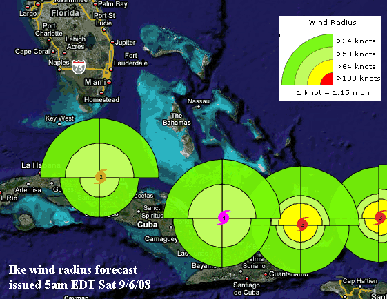 Figure 2. Radius of tropical storm force winds (green colors) and hurricane force winds (yellow colors) along the 5 am EDT Sat 9/6/08 NHC forecast track of Ike. Image was taken from our wundermap for Ike, by clicking on the "hurricane" layer and "wind radius" layer. Note that NHC does not issue a forecast of hurricane force winds for the later time periods, so no yellow colors are shown where Ike is south of Florida. I'll have a short update by 9pm EDT tonight when the new model runs become available. Links to follow: Holguin, Cuba radar Punta De Maisi, Cuba weather Providenciales, Caicos Islands weather Pine Cay, Caicos Islands weather Jeff Masters
The latest set of 18Z (2 pm EDT) computer models
are in, and there is little change from the previous forecasts for days
1-4. All of the models continue to indicate Ike will pass through the
Southeastern Bahamas and hit the north coast of Cuba. On day five and
beyond, there is shift to the west in Ike's track by most of the
models, taking the storm further from Florida into the central Gulf of
Mexico. I've pasted in relevant portions of my previous 5 pm blog
below, unchanged.
Jeff Masters Previous blog from 5 pm Hurricane Ike has re-intensified, and now has Category 4-strength winds, according to the latest data from the Hurricane Hunters. Both an Air Force and a NOAA aircraft recorded surface winds of 135 mph this afternoon on the northeast side of Ike. Category 4 strength winds range from 135-155 mph. Infrared satellite loops show Ike is more symmetric now, with improved upper-level outflow to the north. Shear has fallen from 25 knots this morning to 15 knots this afternoon, allowing this intensification to occur. All of the major models agree that Ike will hit eastern Cuba on Sunday night. After this point, the models continue to diverge. A southern camp of models, the ECMWF and UKMET, take Ike across eastern Cuba and into the western Caribbean, then across the western tip of Cuba or Yucatan Channel between Cuba and Mexico's Yucatan Peninsula. These models predict an eventual landfall near the Mexico/Texas border a week from now. This track would bring tropical storm conditions to the Cancun/Cozumel area beginning Tuesday afternoon or evening, with possible hurricane conditions by Wednesday morning. The northern camp of models, including the GFS, NOGAPS, GFDL, and HWRF, turn Ike west-northwest over Cuba, forecasting that Ike will pop off the coast of Cuba near the Florida Keys on Tuesday, then swing north-northwest. The northward turn is delayed in the current runs, putting Ike into the central Gulf of Mexico, or several hundred miles offshore the western Florida coast. The trough of pressure that pulls Ike to the north is expected to be weak, leaving Ike in a region of weak steering currents. A similar situation occurred in 1985, when Category 3 Hurricane Elena got stranded in the Gulf and wander offshore of the Florida Panhandle for several days. So far, the GFDL has done a good job with Ike, so I will continue to lean towards that track. The GFDL tracks Ike over Cuba until the storm pops off the coast south of the Keys, and intensifies it from a borderline Category 1 or 2 hurricane to a Category 3 hurricane as it passes 50 miles southwest of Key West. The GFDL brings Category 2 winds to Key West. The model then takes Ike north-northwestward into the Gulf of Mexico to an uncertain future. Figure 1. Expected maximum storm tide (storm surge plus adjustment for hitting at high tide) from a Category 3 hurricane moving WNW at 15 mph through the Florida Keys, hitting at high tide. This plot is an ensemble of many different hurricane tracks (shown as black lines), not just one hurricane. The maximum surge from the ensemble is plotted here. The model used is NOAA's SLOSH model. Note that ocean side surge is a foot to two feet lower than bay-side surge. Bay-side surge comes well after the storm center has passed the Keys, from the westerly winds behind the storm. Too many people have been harmed because they thought it was safe to go near the water on the bay side just after a storm has passed. Image credit: Dr. Stephen Baig, NOAA (retired). Florida Keys are at high risk from Ike The danger to the Keys has diminished some, thanks to the continued west-southwest motion of Ike, and the consensus model tracks taking Ike over Cuba or just south of it for a long distance. The Keys are in a Category 2 or 3 evacuation zone, and will be inundated by a direct hit from a Category 2 or 3 hurricane. It's now looking unlikely that Ike will pass through the Keys as a Category 4 hurricane. Category 3 conditions are possible in Key West and the Lower Keys, which would likely bring a maximum storm tide (storm surge plus an adjustment in case the hurricane hits at high tide) of 5-9 feet. Category 1 or 2 conditions are more likely in the Keys, though. I believe there is a 40% chance Ike will bring Category 1 strength winds or higher to Key West and the Lower Keys. The NHC Wind Probability Product forecast gives Key West a 17% chance of receiving hurricane force winds from Ike. Intensity forecast for Ike Sea surface temperatures (SSTs) have warmed to 29.5°C underneath Ike and will warm to 30.0°C over the Gulf of Mexico. Shear has dropped from 25 knots this morning to 15 knots this afternoon, and is forecast to drop below 10 knots tonight. Ike should continue intensifying until the eye contracts to point where it is unstable. The eyewall will collapse, and a new eyewall will form at a much larger radius from the center than before. This process is common in intense hurricanes, and is called an Eyewall Replacement Cycle (ERC). Landfall on Cuba will significantly disrupt the storm, and Ike's strength as it passes the Keys is difficult to guess at this point. The most likely strength is a Category 1, but it could easily be a Category 2 or 3, depending on how long the storm stays over Cuba, and the exact track past the Keys. Once Ike enters the Gulf of Mexico, shear is expected to be low to moderate (10-15 knots), and the ocean is warm, so additional intensification is likely. How will Ike affect the Miami area? Ike's continued west-southwest motion has reduced the danger to South Florida. Miami is now just outside of the cone of uncertainty, so will probably miss a direct hit by Ike. NHC's Wind Probability Product is giving Miami at 7% chance of experiencing hurricane force winds, down from 10% early this morning. If Ike follows the 5 am EDT official forecast, passing to the south of Miami along the north coast of Cuba, the expected region of tropical storm force winds will fall just south of Miami (Figure 2). Figure 2. Radius of tropical storm force winds (green colors) and hurricane force winds (yellow colors) along the 5 am EDT Sat 9/6/08 NHC forecast track of Ike. Image was taken from our wundermap for Ike, by clicking on the "hurricane" layer and "wind radius" layer. Note that NHC does not issue a forecast of hurricane force winds for the later time periods, so no yellow colors are shown where Ike is south of Florida. I'll have a short update by 9pm EDT tonight when the new model runs become available. Links to follow: Holguin, Cuba radar Punta De Maisi, Cuba weather Providenciales, Caicos Islands weather Pine Cay, Caicos Islands weather Jeff Masters
Hurricane Ike
has re-intensified, and now has Category 4-strength winds, according to
the latest data from the Hurricane Hunters. Both an Air Force and a
NOAA aircraft recorded surface winds of 135 mph this afternoon on the
northeast side of Ike. Category 4 strength winds range from 135-155
mph. Infrared satellite loops
show Ike is more symmetric now, with improved upper-level outflow to
the north. Shear has fallen from 25 knots this morning to 15 knots this
afternoon, allowing this intensification to occur.
Track forecast for Ike The latest 12Z (8 am EDT) computer models foresee a probable direct hit by Ike on Grand Inagua Island in the Southeast Bahamas, with the Turks and Caicos Islands also getting hit hard. The eye is about 35 miles in diameter, so a region about 50 miles wide will feel Category 3+ hurricane winds in the Southeast Bahamas. These islands can expect a storm surge of 13-18 feet, and extreme damaging winds. Ike will pass 40-80 miles north of northwestern Haiti, bringing extreme flooding rains of 6-12" to the island of Hispaniola. All of the major models agree that Ike will hit eastern Cuba on Sunday night. After this point, the models continue to diverge. A southern camp of models, the ECMWF and UKMET, take Ike across eastern Cuba and into the western Caribbean, then across the western tip of Cuba or Yucatan Channel between Cuba and Mexico's Yucatan Peninsula. These models predict an eventual landfall near the Mexico/Texas border a week from now. This track would bring tropical storm conditions to the Cancun/Cozumel area beginning Tuesday afternoon or evening, with possible hurricane conditions by Wednesday morning. The northern camp of models, including the GFS, NOGAPS, GFDL, and HWRF, turn Ike west-northwest over Cuba, forecasting that Ike will pop off the coast of Cuba near the Florida Keys on Tuesday, then swing north-northwest. The northward turn is delayed in the current runs, putting Ike into the central Gulf of Mexico, or several hundred miles offshore the western Florida coast. The trough of pressure that pulls Ike to the north is expected to be weak, leaving Ike in a region of weak steering currents. A similar situation occurred in 1985, when Category 3 Hurricane Elena got stranded in the Gulf and wander offshore of the Florida Panhandle for several days. So far, the GFDL has done a good job with Ike, so I will continue to lean towards that track. The GFDL tracks Ike over Cuba until the storm pops off the coast south of the Keys, and intensifies it from a borderline Category 1 or 2 hurricane to a Category 3 hurricane as it passes 50 miles southwest of Key West. The GFDL brings Category 2 winds to Key West. The model then takes Ike north-northwestward into the Gulf of Mexico to an uncertain future. Figure 1. Expected maximum storm tide (storm surge plus adjustment for hitting at high tide) from a Category 3 hurricane moving WNW at 15 mph through the Florida Keys, hitting at high tide. This plot is an ensemble of many different hurricane tracks (shown as black lines), not just one hurricane. The maximum surge from the ensemble is plotted here. The model used is NOAA's SLOSH model. Note that ocean side surge is a foot to two feet lower than bay-side surge. Bay-side surge comes well after the storm center has passed the Keys, from the westerly winds behind the storm. Too many people have been harmed because they thought it was safe to go near the water on the bay side just after a storm has passed. Image credit: Dr. Stephen Baig, NOAA (retired). Florida Keys are at high risk from Ike The danger to the Keys has diminished some, thanks to the continued west-southwest motion of Ike, and the consensus model tracks taking Ike over Cuba or just south of it for a long distance. The Keys are in a Category 2 or 3 evacuation zone, and will be inundated by a direct hit from a Category 2 or 3 hurricane. It's now looking unlikely that Ike will pass through the Keys as a Category 4 hurricane. Category 3 conditions are possible in Key West and the Lower Keys, which would likely bring a maximum storm tide (storm surge plus an adjustment in case the hurricane hits at high tide) of 5-9 feet. Category 1 or 2 conditions are more likely in the Keys, though. I believe there is a 40% chance Ike will bring Category 1 strength winds or higher to Key West and the Lower Keys. The NHC Wind Probability Product forecast gives Key West a 17% chance of receiving hurricane force winds from Ike. Intensity forecast for Ike Sea surface temperatures (SSTs) have warmed to 29.5°C underneath Ike and will warm to 30.0°C over the Gulf of Mexico. Shear has dropped from 25 knots this morning to 15 knots this afternoon, and is forecast to drop below 10 knots tonight. Ike should continue intensifying until the eye contracts to point where it is unstable. The eyewall will collapse, and a new eyewall will form at a much larger radius from the center than before. This process is common in intense hurricanes, and is called an Eyewall Replacement Cycle (ERC). Landfall on Cuba will significantly disrupt the storm, and Ike's strength as it passes the Keys is difficult to guess at this point. The most likely strength is a Category 1, but it could easily be a Category 2 or 3, depending on how long the storm stays over Cuba, and the exact track past the Keys. Once Ike enters the Gulf of Mexico, shear is expected to be low to moderate (10-15 knots), and the ocean is warm, so additional intensification is likely. How will Ike affect the Miami area? Ike's continued west-southwest motion has reduced the danger to South Florida. Miami is now just outside of the cone of uncertainty, so will probably miss a direct hit by Ike. NHC's Wind Probability Product is giving Miami at 7% chance of experiencing hurricane force winds, down from 10% early this morning. If Ike follows the 5 am EDT official forecast, passing to the south of Miami along the north coast of Cuba, the expected region of tropical storm force winds will fall just south of Miami (Figure 2). Figure 2. Radius of tropical storm force winds (green colors) and hurricane force winds (yellow colors) along the 5 am EDT Sat 9/6/08 NHC forecast track of Ike. Image was taken from our wundermap for Ike, by clicking on the "hurricane" layer and "wind radius" layer. Note that NHC does not issue a forecast of hurricane force winds for the later time periods, so no yellow colors are shown where Ike is south of Florida. I'll have a short update by 9pm EDT tonight when the new model runs become available. Links to follow: Holguin, Cuba radar Punta De Maisi, Cuba weather Providenciales, Caicos Islands weather Pine Cay, Caicos Islands weather Jeff Masters
No significant changes have occurred today to Hurricane Ike, and the hurricane remains a borderline Category 2 or 3 storm headed west-southwest towards the Southeastern Bahamas. Infrared satellite loops
show little change in the amount or intensity of Ike's heavy
thunderstorms, and shear of 25 knots continues to restrict upper level
outflow on Ike's northwest side. The eye is showing up intermittently,
and Ike is holding together very well for being under so much shear.
Track forecast for Ike The latest 06Z (2 am EDT) computer models foresee a probable direct hit by Ike on Grand Inagua Island in the Southeast Bahamas, with the Turks and Caicos Islands also getting hit hard. The eye is about 27 miles in diameter, so a region about 50 miles wide will feel Category 3 hurricane winds in the Southeast Bahamas. These islands can expect a storm surge of 6-12 feet, and extreme damaging winds. Ike will pass 40-80 miles north of northwestern Haiti, and will bring rains of 3-6" to the Dominican Republic, and 4-8" to northern Haiti. These rains will likely cause additional severe flooding in Haiti, where the death toll is nearing 200 in the aftermath of Hurricane Hanna. All of the major models agree that Ike will hit eastern Cuba on Sunday night. After this point, the models diverge. A southern camp of models, the ECMWF and UKMET, take Ike across eastern Cuba and into the western Caribbean, then through the narrow Yucatan Channel between Cuba and Mexico's Yucatan Peninsula, eventually hitting Texas a week from now. This track would bring tropical storm conditions to the Cancun/Cozumel area beginning Tuesday afternoon or evening, with possible hurricane conditions by Wednesday morning. The northern camp of models, including the GFS, NOGAPS, GFDL, and HWRF, turn Ike west-northwest over Cuba, forecasting that Ike will pop off the coast of Cuba near the Florida Keys on Tuesday, then swing north to threaten the west coast of Florida. The NOGAPS and GFDL both forecast that Ike will pass within 50 miles of Tampa on Thursday, while the GFS and HWRF put Ike several hundred miles off the west coast of Florida. I'm leaning towards this northern solution, since the GFDL model has been performing so well for both Ike and Gustav. The GFDL forecasts Category 3 strength winds will affect Key West and the Upper Keys, despite a track by Ike over Cuba. Florida Keys are at very high risk from Ike The Florida Keys are highly vulnerable to hurricanes, thanks to the presence of but one road out of Key West. The entire chain of islands is in a Category 2 or 3 evacuation zone, and will be inundated by a direct hit from a Category 2 or 3 hurricane. During Hurricane Donna of 1960, a storm surge of 4-13 feet affected the Keys (Figure 1). Donna was a Category 4 hurricane when it passed through the Lower Keys. In general, a Category 4 hurricane moving WNW like Ike is expected to bring a maximum storm tide (storm surge plus a correction for if the hurricane hits at high tide) of 9-10 feet (Figure 2). I believe there is a 30% chance Ike will bring Category 2 strength winds or higher to the Keys, with the Middle and Lower Keys being the most likely targets. this is higher than the NHC Wind Probability Product forecast, which gives Key West a 15% chance of receiving hurricane force winds from Ike.  Figure 1. Observed high water marks in the Keys from Hurricane Donna of 1960. Image credit: "Characteristics of the Hurricane Storm Surge" by D. Lee Harris, U.S. Weather Bureau, 1963. Intensity forecast for Ike Sea surface temperatures (SSTs) have warmed to 29.5°C underneath Ike and will warm to 30.0°C over the Gulf of Mexico. Shear is 25 knots this morning, and is forecast to drop below 10 knots tonight. Ike should start intensifying tonight. Landfall on Cuba will significantly disrupt the storm, and Ike's strength as it passes the Keys is difficult to guess at this point. The most likely strength is a Category 2, but it could easily be a Category 1 or 3, depending on how long the storm stays over Cuba, and the exact track through the Keys. Once Ike enters the Gulf of Mexico, shear is expected to be low to moderate (10-15 knots), and the ocean is warm, so additional intensification is likely.  Figure 2. Expected maximum storm tide (storm surge plus adjustment for hitting at high tide) from a Category 4 hurricane moving WNW at 15 mph through the Florida Keys, hitting at high tide. This plot is an ensemble of many different hurricane tracks (shown as black lines), not just one hurricane. The maximum surge from the ensemble is plotted here. The model used is NOAA's SLOSH model. Note that ocean side surge is a foot to two feet lower than bay-side surge. Bay-side surge comes well after the storm center has passed the Keys, from the westerly winds behind the storm. Too many people have been harmed because they thought it was safe to go near the water on the bay side just after a storm has passed. Image credit: Dr. Stephen Baig, NOAA (retired). How will Ike affect the Miami area? Don't get fixated on the official forecast or the computer model tracks showing Ike passing to the south of Miami through the Keys or over Cuba. Miami is still in the cone of uncertainty, and is at risk from a direct hit by a Category 4 hurricane. I'd put the odds of a direct hit by Ike on the East Coast of Florida north of the Keys at around 20%. NHC's Wind Probability Product is giving Miami at 10% chance of experiencing hurricane force winds. If Ike follows the 5 am EDT official forecast, passing to the south of Miami along the north coast of Cuba, the expected region of tropical storm force winds will fall just south of Miami, though (Figure 4). Figure 3. Radius of tropical storm force winds (green colors) and hurricane force winds (yellow colors) along the 5 am EDT Sat 9/6/08 NHC forecast track of Ike. Image was taken from our wundermap for Ike, by clicking on the "hurricane" layer and "wind radius" layer. Note that NHC does not issue a forecast of hurricane force winds for the later time periods, so no yellow colors are shown where Ike is south of Florida. I'll have a full blog entry this afternoon at about 4pm. I'll be on the radio on the "Science Fantastic with Dr. Michio Kaku" show Saturday at 5:20 pm on http://talkradionetwork.com/. It's a call in show, so you can ask questions. Jeff Masters
Just a quick update on the expected track for Hurricane Ike--the latest
18Z (2 pm EDT) computer model runs have completed. The newest tracks of
the GFDL, HWRF, and UKMET are all about 50 miles further south than
before, bringing Ike over eastern Cuba, then along Cuba or just south
of Cuba before popping out into the Gulf of Mexico. The other two
models, the GFS and NOGAPS, did not change their forecasts appreciably,
and forecast a track through the Keys without hitting Cuba. These new
model runs imply a slight lessening of the risk of Ike hitting South
Florida, Southwest Florida, and the central and western Bahamas.
However, the risk to the Keys is still unacceptably high, and a
mandatory evacuation order has been given. I urge all Keys residents to
comply with the evacuation orders. Ike is capable of causing a 14-foot
storm surge in the Keys, as Hurricane Donna did in 1960. This is a
storm you must evacuate for.
Figure 1. Expected maximum storm tide (storm surge plus adjustment for hitting at high tide) from a Category 4 hurricane moving WNW at 15 mph through the Florida Keys, hitting at high tide. This plot is an ensemble of many different hurricane tracks (shown as black lines), not just one hurricane. The maximum surge from the ensemble is plotted here. The model used is NOAA's SLOSH model. Note that oceanside surge is a foot to two feet lower than bay-side surge. Bay-side surge comes well after the storm center has passed the Keys, from the westerly winds behind the storm. Too many people have been harmed because they thought it was safe to go near the water on the bay side just after a storm has passed. Image credit: Dr. Stephen Baig, NOAA. My previous blog has my 5pm thoughts on things. See you in the morning. Jeff Masters
Tropical Storm Hanna
remains close to hurricane strength as it approaches landfall in South
Carolina early Saturday morning. The latest 4:11 pm EDT center fix from
the Hurricane Hunters found a central pressure of 984 mb, up 4 mb from
the 7 am reading. Peak winds measured by the SFMR instrument were in
the 65-75 mph range. Radar animations
from the Charleston, SC radar show that Hanna does not have an eyewall,
so this will limits its intensification potential. There has been
little change in the organization of Hanna's spiral bands, and the
amount and intensity of the precipitation has stayed about the same in
recent hours. The outermost spiral bands of Hanna are spreading
intermittent heavy rains along the east coast of Florida, Georgia,
South Carolina, and North Carolina. Wind shear has fallen from 20 knots
to 15 knots this afternoon, which may allow Hanna to intensify slightly
before landfall. Visible satellite loops
of Hanna show a much more symmetric and well-organized system, and
Hanna will may start building an eyewall in the next few hours.
However, it doesn't have much time to do so, and the strongest it can
get is a Category 1 hurricane with 80 mph winds.
Figure 1. Latest radar image of Hanna. The forecast for Hanna A landfall in South Carolina is the unanimous consensus of the the computer models, and this landfall will occur near midnight tonight. Hanna is a large storm with winds well removed from the center. Coastal North Carolina and South Carolina will see winds near hurricane force (74 mph) from this storm. Given that Hanna is so large and fast-moving, the entire mid-Atlantic and New England coast should see sustained winds near tropical storm force (39 mph) this weekend as Hanna zooms northeast. Links to follow Charleston, SC weather Myrtle Beach, SC weather The U.S. is getting pummeled this hurricane season With hurricane season less than half over, it's clear that the U.S. is taking an unusually harsh beating this year. Already, we've had two Category 2 hurricanes (Dolly and Gustav), two strong tropical storms (Edouard and Fay), and now a third strong tropical storm or Category 1 hurricane (Hanna). Hanna is the fifth consecutive named storm to hit the U.S., tying a record. The other years this happened (kudos to NOAA's Ryan Sharp for compiling this): 2004 (Frances, Gaston, Hermine, Ivan, and Jeanne) 2002 (Edouard, Fay, Gustav, Hanna, and Isidore) 1985 (Gloria, Henri, Isabel, Juan, and Kate) 1979 (Bob, Claudette, David, Elena, and Frederic) 1971 (Doria, Edith, Fern, Ginger, Heidi) There's good chance that Ike will make it six consecutive strikes. Ike Hurricane Ike has taken a beating from wind shear, and its top winds have decreased to borderline Category 2/Category 3 strength, about 115 mph, according to data this afternoon taken by the Hurricane Hunters. Infrared satellite loops show that the cloud tops are warming over the core of the hurricane, and the amount and intensity of heavy thunderstorm activity continue to decrease. The eye has disappeared on satellite imagery, and the Hurricane Hunters noticed a gap in the northwest side of the eyewall. Ike is not symmetric, and is flattened on the northwest side, where there is no upper-level outflow. This is due to 25 knots of wind shear impacting the storm, thanks to strong upper-level winds out of the northwest. The shear is enabling dry air to penetrate deep into the core of the storm, disrupting it.  Figure 2. Microwave satellite image of Ike from 7:48 am EDT 9/5/08. Ike's eye is getting tough to pick out, thanks to wind shear eroding away the northwest past of the eyewall. The eye is the blue dot at center; most of Ike's heavy thunderstorms (red colors) are on the southeast side of the hurricane. Image credit: Navy Research Lab, Monterey. Track forecast for Ike The latest 12Z (8am EDT) computer models increase the risk for a direct hit by Ike on the Bahamas, Cuba, Florida Keys, and South Florida. The models are grouped more tightly now around a track through the Southeast Bahama Islands, then west-northwest, over or just north of Cuba towards South Florida and the Keys. None of the major models are expecting Ike to recurve and miss the U.S. It now appears likely that Ike will have three landfalls--one in the Southeast Bahamas, one in northern Cuba or the Florida Keys/South Florida, and one on the Gulf Coast. The trough of low pressure expected to turn Ike to the north is, in general, weaker and slower moving than originally forecast, resulting in a delayed turn by Ike to the north. Several models--the UKMET, ECMWF, and Canadian--forecast the trough will not pull Ike to the north at all, and the storm will track west-northwest into the middle of the Gulf of Mexico by the middle of next week. The other models--NOGAPS, GFS, HWRF, and GFDL--all foresee a turn to the north, but this turn is delayed until Ike reaches the Keys. All of these scenarios look bad for the Florida Keys, and there is a high probability the Key will have to be evacuated. The furthest south models continue to be the GFDL and ECMWF, which take Ike into northeastern Cuba Sunday. The GFDL forecasts Ike will be a Category 3 hurricane when it hits Cuba, then weaken to a Category 2 when it pops off the coast of Cuba on Tuesday and passes through the Upper Keys. This currently appears to the best-case scenario for the Keys. If Ike misses Cuba, as the other models predict, the Keys can expect a major Category 3 or higher hurricane. Tropical storm force winds can be expected in the Keys as early as Monday night. Once the storm reaches the Keys, we have three models that turn Ike to the north, resulting in a Gulf Coast landfall along the west coast of Florida. Ike's path and intensity could well imitate those of Hurricane Donna of 1960, which blasted through the Keys as a Category 4 hurricane, then up the west coast of Florida. It is also possible that the trough of low pressure will not be strong enough to turn Ike to the north, and that the storm will enter the Gulf of Mexico. A second trough of low pressure would then turn Ike north later in the week, resulting in an eventual landfall on the Gulf Coast between the Florida Panhandle and Texas. This is the forecast of the ECMWF, UKMET, and Canadian models. It is too early to speculate where on the Gulf Coast Ike would hit. Florida Keys are at high risk from Ike The Florida Keys are highly vulnerable to hurricanes, and are at great risk from Ike. With only one road connecting the Keys to the mainland, 48-72 hours are required to evacuate the Keys. Tropical storm force winds can be expected in the Keys as early as Monday night, which means officials in the Keys may need to start ordering evacuations on Saturday morning. This would likely begin as an evacuation of visitors and tourists.  Figure 2. Forecast tracks for Ike from the latest run of the GFS model ensemble. The ensemble is generated by initializing the GFS model with 21 slightly different initial conditions, then plotting where Ike goes with each model run. There are a lot of possibilities! The white line is what the operational version of the GFS model predicts. The GFS ensemble is not available as quickly as the regular operation version of the GFS. Intensity forecast for Ike Sea surface temperatures (SSTs) have warmed to 29.2°C and will warm an extra 0.5°C over the next three days. However, the shear is forecast to be unfavorable for intensification through Saturday morning: 20-30 knots. The high shear may be able to reduce Ike to a Category 1 storm by Saturday morning. Re-intensification is likely beginning on Saturday night, when the shear is forecast to fall below 5 knots. It should take Ike at least a day to recover to Category 3 strength, meaning that the Southeast Bahamas may be spared a major hurricane. The shear is forecast to remain below 15 knots Saturday through Tuesday. The low shear and warm waters favor re-intensification of Ike into a major hurricane by Monday. Ike's projected damage The primary danger in the Bahama Islands will be wind damage, since the storm surge typically flows around small islands. However, a Category 4 or 5 hurricane is capable of generating a maximum storm surge of 13 feet in the Turks and Caicos Islands on the right side of the eye, if it makes a direct hit on an island. On Haiti and in Cuba, there is the potential for very heavy rains of 4-8 inches or higher, beginning on Saturday night. These rains could be particularly devastating for northern Haiti, where the ground is already saturated due to Hurricane Hanna's rains. Hanna killed at least 137 people in Haiti, and over 600,000 people need assistance there. Heavy rains of 3-6 inches are possible in the Dominican Republic. Josephine There's been little change to Tropical Storm Josephine today, which continues to struggle against the twin effects of wind shear and dry air. The models are split on whether Josephine will survive. If it does, the storm may be a threat to Bermuda in a week or so. Elsewhere in the tropics The GFS model has considerably toned down its forecasts of tropical waves coming off the coast of Africa that develop. It now forecasts that just one new tropical storm will form over the next two weeks. I'll be available on a chat forum at 5:15 pm EDT today at http://news-press.com/masterschat2 I'll also be on the radio on the "Science Fantastic with Dr. Michio Kaku" show Saturday at 5:20 pm on http://talkradionetwork.com/. It's a call in show, so you can ask questions. Record rate of Arctic sea ice loss in August In climate news that has implications for our children and grandchildren that will be living in Hurricane Alley, the National Snow and Ice Data Center has reported that the rate of sea ice loss in the Arctic was the greatest on record during August. Sea ice continues to decline, and we may break the record for least sea ice coverage, set just last year. This summer's decline in sea ice reinforces the possibility that significant melting of the Greenland Ice Sheet may occur in the coming decades, raising sea levels on the order of 1-3 feet by the end of the century. This will greatly increase the damage potential from hurricane storm surges. My next blog entry will be Saturday morning. Jeff Masters
Tropical Storm Hanna
is becoming better organized as it approaches landfall in South
Carolina early Saturday morning. The latest 7:11 am EDT center fix from
the Hurricane Hunters found a central pressure of 980 mb, down 5 mb
from the 5 am reading. Peak winds were mostly in the 55-65 mph range. Radar animations
from the Melbourne radar show that Hanna has built about 1/3 of an
eyewall. There has been a slight increase in the organization of
Hanna's spiral bands, and the amount and intensity of the precipitation
has increased. The outermost spiral bands of Hanna are spreading
intermittent heavy rains along the east coast of Florida, and these
rains will spread into Georgia, South Carolina, and North Carolina
later today. Wind shear of 20 knots continues to interfere with Hanna's
organization, and there is also plenty of dry air interfering.
Figure 1. Latest radar image of Hanna. The forecast for Hanna A landfall in South Carolina is the unanimous consensus of the the computer models, and this landfall will occur near midnight tonight. Hanna is a large storm with winds well removed from the center. Both North Carolina and South Carolina will see winds of 50-60 mph from this storm. Given that Hanna is so large and fast-moving, the entire mid-Atlantic and New England coast should see sustained winds near tropical storm force (39 mph) this weekend as Hanna zooms northeast. The wind shear is forecast to remain in the moderate to marginal range, 15-20 knots, over the remainder of Hanna's life. There is a large amount of dry continental air lying between Hanna and South Carolina, which will continue to cause problems for the storm. However, sea surface temperatures are a warm 29°C. None of the intensity models forecast Hanna will become a hurricane, but given the recent increase in the storm's organization, I forecast a 40% chance that Hanna will be a Category 1 hurricane at landfall. Rapid intensification of Hanna is very unlikely, and the strongest I can see this storm getting is a Category 1 storm with top winds of 80 mph. The most likely top winds at landfall will be 70 mph, just below hurricane strength. Links to follow Melbourne, FL radar Myrtle Beach, SC weather The U.S. is getting pummeled this hurricane season With hurricane season less than half over, it's clear that the U.S. is taking an unusually harsh beating this year. Already, we've had two Category 2 hurricanes (Dolly and Gustav), two strong tropical storms (Edouard and Fay), and now a third strong tropical storm or Category 1 hurricane (Hanna). Hanna is the fifth consecutive named storm to hit the U.S., tying a record. The other years this happened (kudos to NOAA's Ryan Sharp for compiling this): 2004 (Frances, Gaston, Hermine, Ivan, and Jeanne) 2002 (Edouard, Fay, Gustav, Hanna, and Isidore) 1985 (Gloria, Henri, Isabel, Juan, and Kate) 1979 (Bob, Claudette, David, Elena, and Frederic) 1971 (Doria, Edith, Fern, Ginger, Heidi) There's good chance that Ike will make it six consecutive strikes. Ike Hurricane Ike remains a large and dangerous Category 3 hurricane today, despite the presence of about 25 knots of hostile wind shear. Infrared satellite loops show that the cloud tops are not warming over the core of the hurricane, but the storm has a squashed appearance. Ike is flattened on the northwest side, where there is no upper-level outflow. This is due to 25 knots of wind shear impacting the storm, thanks to strong upper-level winds out of the northwest. The shear is enabling dry air to penetrate deeper into the core of the storm, and the shear and dry air have made it into the inner core and are now disrupting the eyewall (Figure 2). Figure 2. Microwave satellite image of Ike from 7:48 am EDT 9/5/08. Ike's eye is getting tough to pick out, thanks to wind shear eroding away the northwest past of the eyewall. The eye is the blue dot at center; most of Ike's heavy thunderstorms (red colors) are on the southeast side of the hurricane. Image credit: Navy Research Lab, Monterey. Track forecast for Ike Ike has begun a west-southwest motion in recent hours, which increases the probability that the hurricane will enter the Southeast Bahama Islands on Sunday. The computer models which called for this more southerly path include the GFDL and HWRF models. With its latest run (06Z, 2am EDT) the GFDL takes Ike through the Southeast Bahamas and Turks and Caicos Islands as a Category 3 hurricane early Sunday morning. The HWRF has the same track, but makes Ike a Category 4. The two models then diverge, with the GFDL taking Ike into eastern Cuba as a Category 3 hurricane on Monday, and along the length of Cuba into the Florida Keys as a Category 2 hurricane on Wednesday morning. The HWRF has Ike skirting the northern coast of Cuba, arriving at Key Largo, Florida as a Category 4 hurricane on Tuesday night. Considerable uncertainty surrounds the path of Ike once the storm reaches the vicinity of South Florida, since a trough of low pressure capable of turning Ike to the north will be passing to the north. A turn to the north over South Florida, or just on either side of the state is possible. One possible track, similar to the NOGAPS model forecast, takes Ike near or over Miami, then northwards towards North Carolina. This is a track similar to Hurricane Floyd of 1999. Another feasible track, similar to the HWRF solution, is like Hurricane Donna of 1960, which blasted through the Keys as a Category 4 hurricane, then up the west coast of Florida. It is also possible that the trough of low pressure will not be strong enough to turn Ike to the north, and that the storm will enter the Gulf of Mexico. A second trough of low pressure would then turn Ike north, resulting in a n eventual landfall on the Gulf Coast between the Florida Panhandle and Texas. This is the forecast of the ECMWF and GFS models. My current thinking is along these lines: 20% chance Ike will hit the east coast of Florida. 30% chance Ike will hit the Florida Keys. 30% chance Ike will hit Cuba. If this happens, there is 30% chance it would miss Florida and head into the Gulf of Mexico. 10% chance that Ike will miss Florida, but hit further north along the U.S. coast. 10% chance Ike will curve north out to sea and not hit the U.S. Overall, I'd give the Gulf Coast a 70% chance of getting hit (including the west coast of Florida). Florida Keys are at high risk The Florida Keys are highly vulnerable to hurricanes, and are at great risk from Ike. With only one road connecting the Keys to the mainland, a 48-72 hours are required to evacuate the Keys. Tropical storm force winds can be expected in the Keys on Tuesday afternoon, which means officials in the Keys may need to start ordering evacuations on Saturday. This would likely begin as an evacuation of visitors and tourists on Saturday afternoon or Sunday morning. Figure 3. Forecast tracks for Ike from the latest run of the GFS model ensemble. The ensemble is generated by initializing the GFS model with 21 slightly different initial conditions, then plotting where Ike goes with each model run. There are a lot of possibilities! The white line is what the operational version of the GFS model predicts. The GFS ensemble is not available as quickly as the regular operation version of the GFS. Intensity forecast for Ike Sea surface temperatures (SSTs) have warmed to 29.0°C and will warm an extra 0.5°C over the next three days. However, the shear is forecast to be unfavorable for intensification through Saturday morning: 20-30 knots. The high shear may be able to reduce Ike to a Category 1 storm by Saturday morning. The shear has eaten its way into the northwestern eyewall, as seen in recent microwave imagery (Figure 2). Re-intensification is likely beginning on Saturday afternoon, when the shear is forecast to fall below 15 knots. It should take Ike at least a day to recover to Category 3 strength, meaning that the Southeast Bahamas may be spared a major hurricane. The shear is forecast to remain below 15 knots Saturday through Tuesday. If Ike enters the central and western Bahamas, the oceanic heat content reaches a maximum--80 kJ/cm^2, similar to the levels of heat content that fueled Gustav's rapid intensification south of Cuba. Ike may also be moving under an upper-level anticyclone then, which would provide very favorable conditions for intensification. If Ike hits Florida, it will probably be at Category 3 strength or higher, assuming the storm misses Cuba. If Ike hits Cuba first, Florida can expect a Category 1 or 2 hurricane. Ike's projected damage The primary danger in the Bahama Islands will be wind damage, since the storm surge typically flows around small islands. However, a Category 4 or 5 hurricane is capable of generating a maximum storm surge of 13 feet in the Turks and Caicos Islands on the right side of the eye, if it makes a direct hit on an island. On Haiti and in Cuba, there is the potential for very heavy rains of 4-8 inches or higher, beginning on Saturday night. These rains could be particularly devastating for northern Haiti, where the ground is already saturated due to Hurricane Hanna's rains. Hanna killed at least 137 people in Haiti, and over 600,000 people need assistance there. Josephine Tropical Storm Josephine continues to struggle against the twin effects of wind shear and dry air. The models are split on whether Josephine will survive. If it does, the storm may be a threat to Bermuda in a week or so. Elsewhere in the tropics The GFS model has considerably toned down its forecasts of tropical waves coming off the coast of Africa that develop. It now forecasts that just one new tropical storm will form over the next two weeks. Why hurricanes recurve The prevailing winds over the U.S. are from west to east, but in the tropics, they blow east to west. This pattern arises because we live on the surface of a spinning sphere that is heated unequally at the poles and equator. When a hurricane forms in the tropics, it moves east to west with the prevailing winds. However, if the storm gets far enough north, it will suddenly encounter a flow of air moving the opposite direction. This will force the hurricane to move northwards and then eastwards, as the storm gets caught up in the west to east flow of air. The boundary between these two air flow regimes fluctuates, depending upon the position of the jet stream. When a low pressure system moves across the U.S., the jet stream dips to the south, bringing the prevailing west to east winds over the U.S. closer to the tropics. Thus, hurricanes are more prone to recurve to the north when there is an approaching low pressure system passing to their north. My next blog entry will be this afternoon. I've gotten several complaints that I'm only updating the blog once per day; I assure you that I've been doing twice daily updates for several weeks, and these will continue for the foreseeable future. Those experiencing problems may have browser refresh issues on their computer. Jeff Masters
Tropical Storm Hanna
has not changed much, and remains on track to hit North or South
Carolina as a tropical storm or Category 1 hurricane Friday night.
Hanna has characteristics of a subtropical storm.
A subtropical storm tends not to have any heavy thunderstorm activity
near its center. Instead, the heaviest rain is located in a band 100 or
more miles from the center. The difference is not important as far as
the winds are concerned, since both types of storms generate similar
winds. Satellite loops
show that Hanna has one spot of heavy thunderstorm activity to the
northwest of the center, and there is also a band of heavy
thunderstorms several hundred miles north of the center. This band will
hit the Carolinas well before the storm's center arrives.
Wind shear of 20 knots continues to interfere with Hanna's organization, and there is also plenty of dry air to its west that is causing the storm trouble. The amount and intensity of Hanna's thunderstorms has not changed much in the past day, and the central pressure has remained in the 985-990 mb range. The latest Hurricane Hunter report found a central pressure of 988 mb, with surface winds of 50-60 mph, at 3:17 pm EDT. 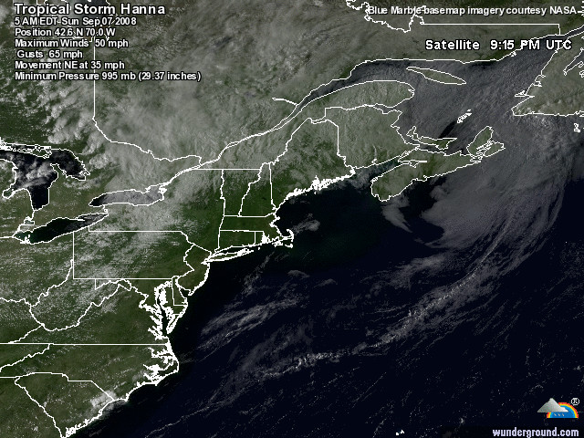 Figure 1. Latest satellite image of Hanna. The track forecast for Hanna The computer models continue to come into better agreement on Hanna's track. Hanna will come ashore in North Carolina or northern South Carolina. The exact landfall location is relatively unimportant in this case, since Hanna is a large storm with winds well removed from the center. Both North Carolina and South Carolina will see winds of 50-60 mph from this storm. Given that Hanna is so large and fast-moving, the entire mid-Atlantic and New England coast should see sustained winds near tropical storm force (39 mph) this weekend as Hanna zooms northeast. The intensity forecast for Hanna The wind shear is forecast to remain in the moderate to marginal range, 15-25 knots, over the remainder of Hanna's life. There is a large amount of dry continental air lying between Hanna and South Carolina, which will continue to cause problems for the storm. However, sea surface temperatures are a warm 29°C. The main intensity models--HWRF, GFDL, and SHIPS--all forecast that Hanna will not become a hurricane. Given the rather subtropical appearance of Hanna, with the heaviest thunderstorms well removed from the center, plus the rather high wind shear over the storm, rapid intensification is very unlikely. A tropical storm needs to have its heaviest thunderstorms close to the center in order to undergo significant strengthening. Hanna should intensify slowly, if at all, and be no stronger than a Category 1 hurricane with 80 mph winds at landfall in the U.S. Ike Hurricane Ike remains a large and dangerous Category 4 hurricane today, despite the presence of about 20 knots of hostile wind shear. Satellite estimates of Ike's intensity remain unchanged from early this morning, but infrared satellite loops show that the cloud tops are warming over the core of the hurricane, signifying weakening. The storm has a squashed appearance, and is flattened on the northwest side, where there is no upper-level outflow. This is due to 20 knots of wind shear impacting the storm, thanks to strong upper-level winds out of the northwest. The shear is enabling dry air to penetrate deeper into the core of the storm. Track forecast for Ike The computer models were in two distinct camps this morning, but are now in better agreement on a more southerly track for Ike. This increases the danger for the Bahamas, Haiti, Cuba, and Florida. A southward component of motion is now forecast by all of the computer models except the UKMET, making it very likely that Ike will move into the Bahamas by Sunday. The GFDL is the furthest south, projecting a landfall in Cuba as a Category 3 or 4 hurricane on Sunday night. The UKMET is the furthest north, projecting that Ike will miss the Bahamas, but hit South Florida. All of the models bring Ike within 200 miles of Miami by Tuesday. The HWRF brings Ike to a point 50 miles from Miami on Tuesday, as a Category 4 hurricane. Figure 2. Forecast tracks for Ike from the latest run of the GFS model ensemble. The ensemble is generated by initializing the GFS model with 21 slightly different initial conditions, then plotting where Ike goes with each model run. There are a lot of possibilities! The black line is what the operational version of the GFS model predicted in its previous cycle (6 hours before the ensemble plotted here). Forecast points are not 12 hours apart, as stated. Ike's long-term fate has two main possibilities: 1) Ike may hit eastern Cuba, as forecast by the latest (12Z, 8am EDT) runs of the GFDL and ECMWF models, and a number of ensemble members of the latest 12Z GFS model (Figure 2). A hit on Cuba would severely disrupt the storm, weakening it to a Category 1 or 2. Ike could then move on into the Gulf of Mexico and re-intensify, as forecast by the ECMWF model. 2) Ike may plow through the Bahamas and come very close to South Florida (the consensus of the HWRF, NOGAPS, and GFS models). A trough of low pressure may then pull Ike to north. This turn to the north might occur over Florida, or over the western Bahamas, within 200 miles of the Florida coast. In the latter case, North Carolina might be at risk. The recent model trend has been to depict a weaker trough, resulting in Ike getting stranded, like Fay and Gustav did. Ike would resume a slow motion to the west as ridge of pressure builds in, potentially crossing Florida into the Gulf of Mexico. There is a third possibility--Ike may recurve before hitting the U.S., and move harmlessly out to sea. That possibility appears lower probability than cases 1 and 2 above, at this point. Intensity forecast for Ike Sea surface temperatures (SSTs) have warmed to 28.5°C and will warm an extra degree over the next two days. However, the shear is forecast to be unfavorable for intensification through Friday night: 20-30 knots. The high shear may be able to disrupt the inner core of Ike, reducing it to a Category 2 storm by Friday night. Re-intensification is likely beginning on Saturday morning, when the shear is forecast to fall below 10 knots. The shear is forecast to remain below 10 knots Saturday through Tuesday. On Sunday, when Ike may be approaching the southeastern Bahamas, it should encounter cooler waters stirred up by Hurricane Hanna. This may limit the re-intensification. Once Ike crosses Hanna's wake and enters the central and western Bahamas, the oceanic heat content reaches a maximum--80 kJ/cm^2, similar to the levels of heat content that fueled Gustav's rapid intensification south of Cuba. Ike may also be moving under an upper-level anticyclone then, which would provide very favorable conditions for intensification. Ike's projected damage The primary danger in the Bahama Islands will be wind damage, since the storm surge typically flows around small islands. However, a Category 4 or 5 hurricane is capable of generating a maximum storm surge of 13 feet in the Turks and Caicos Islands on the right side of the eye, if it makes a direct hit on an island. On Haiti and in Cuba, there is the potential for very heavy rains of 4-8 inches or higher, beginning on Saturday night. These rains could be particularly devastating for northern Haiti, where the ground is already saturated due to Hurricane Hanna's rains. Hanna killed at least 90 people in Haiti, and the situation there is being described as desperate. The first Hurricane Hunter mission into Ike is scheduled for Friday morning. Josephine Tropical Storm Josephine has been severely damaged by the twin effects of wind shear and dry air. The storm is a low-level swirl with a llittle thunderstorm activity to the north. The storm is forecast to dissipate by several of the models. However, most of the models predict it will hang in there and eventually eventually track north of the Lesser Antilles Islands. Elsewhere in the tropics The GFS model has considerably toned down its forecasts of tropical waves coming off the coast of Africa that develop. It now forecasts that just one new tropical storm will form over the next two weeks. Gustav With two other storms to be concerned with, my day quickly runs out of time to talk about the aftermath of Gustav. Louisiana, Mississippi, and Arkansas continue to grapple with the damage and flooding wrought by Gustav. Gustav has dropped up to 20 inches of rain on central Louisiana (Figure 3), and spawned 50 tornadoes. Gustav took out the power to huge sections of the state (Figure 4). 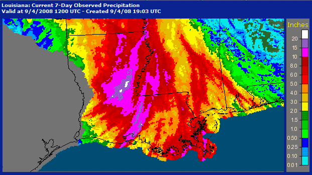 Figure 3. Total rainfall from Gustav. Figures were not available for Texas and extreme western Louisiana. Image credit: NOAA/HPC. 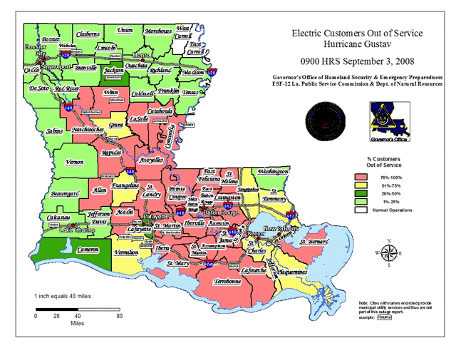 Figure 4. Power outage status for Louisiana, as of 9am Wednesday. Why hurricanes recurve The prevailing winds over the U.S. are from west to east, but in the tropics, they blow east to west. This pattern arises because we live on the surface of a spinning sphere that is heated unequally at the poles and equator. When a hurricane forms in the tropics, it moves east to west with the prevailing winds. However, if the storm gets far enough north, it will suddenly encounter a flow of air moving the opposite direction. This will force the hurricane to move northwards and then eastwards, as the storm gets caught up in the west to east flow of air. The boundary between these two air flow regimes fluctuates, depending upon the position of the jet stream. When a low pressure system moves across the U.S., the jet stream dips to the south, bringing the prevailing west to east winds over the U.S. closer to the tropics. Thus, hurricanes are more prone to recurve to the north when there is an approaching low pressure system passing to their north. When hurricanes collide Many readers have asked if Hanna and Ike could collide and make a super hurricane. Well, hurricanes cannot collide to make a bigger hurricane. When hurricanes get within about 900 miles of each, they begin to interact. There are three possible outcomes: 1) The larger storm will destroy the smaller one. The larger storm's upper-level outflow will bring hostile wind shear over the smaller storm, and the larger storm may steal the smaller storm's moisture. This occurred in 2005, when Hurricane Wilma destroyed Tropical Storm Alpha over Hispaniola. 2) Both hurricanes will compete for the same energy, resulting in weakening of both storms. 3) The storms will rotate around a common center of rotation (the Fujiwhara Effect), before going on their separate ways. Hurricane Humberto and Hurricane Iris took part in a brief Fujiwhara interaction in 1995. Iris then began interacting with a third storm, Tropical Storm Karen, which orbited and later merged with the more intense Iris. In cases, the two storms will merge, such as occurred in 1997 in the Pacific with Typhoon Yule and TD 16W. Sometimes, a recurving hurricane will leave behind an enhanced trough of low pressure that will act to help recurve the storm behind it along the same path. This is possible this week with Ike and Hanna. My next blog entry will be Friday morning. Jeff Masters
Tropical Storm Hanna is a large and very odd looking near-hurricane. In fact, it looks to me like it is more like a subtropical storm
than a tropical storm. A subtropical storm tends not to have any heavy
thunderstorm activity near its center. Instead, the heaviest rain is
located in a band 100 or more miles from the center. Satellite loops
show that this is the case with Hanna. Wind shear of 20 knots continues
to interfere with Hanna's organization, and there is also plenty of dry
air to its west that is causing the storm trouble. The amount and
intensity of Hanna's thunderstorms has not changed much in the past
day, and the central pressure has remained in the 985-990 mb range. The
latest Hurricane Hunter report found a central pressure of 989 mb, with
surface winds of 60 mph, at 6:33 am EDT.
Figure 1. Latest satellite image of Hanna. Hanna hits Haiti hard Hanna's flooding rains have killed at lest 61 people in northern Haiti. Hardest hit was the northern town of Gonaives, a city of 110,000 where over 2,000 people perished in 2004 due to rains from Hurricane Jeanne. Satellite estimates suggest 6-8 inches of rain fell on northern Haiti and the northern Dominican Republic due to Hanna. The death toll is likely to go higher, since rescuers have not been able to reach surrounding remote areas. Rains from Hurricane Ike are likely to make the misery worse of Sunday, when the hurricane is expected to pass north of Haiti and bring at least 2-4 more inches of rain. Northern Haiti is highly prone to flooding disasters, due to the steep mountainsides in the region that have had 98% of their forests chopped down. The track forecast for Hanna The computer models have come into a bit better agreement on Hanna's track, due in part to the data from a dropsonde mission flown last night by the NOAA jet. Hanna will come ashore in North Carolina or northern South Carolina. The exact landfall location is relatively unimportant in this case, since Hanna is a large storm with the winds well removed from the center. Both North Carolina and South Carolina will see winds near hurricane strength from this storm. Given that Hanna is so large and fast-moving, the entire mid-Atlantic and New England coast will see sustained winds of at least tropical storm force (39 mph) this weekend as Hanna zooms northeast. The intensity forecast for Hanna The wind shear is forecast to remain in the moderate to marginal range, 15-25 knots, over the remainder of Hanna's life. There is a large amount of dry continental air lying between Hanna and South Carolina, which will continue to cause problems for the storm. However, sea surface temperatures are a warm 29°C. The main intensity models, which yesterday thought that Hanna would not become a hurricane--have changed their tune. The HWRF the the most aggressive, predicting that Hanna will come ashore in northern South Carolina as a Category 1 hurricane with 90 mph winds early Saturday morning. The other intensity guidance is less aggressive, predicting top winds in the 55-75 mph range at landfall. Given the rather subtropical appearance of Hanna, with the heaviest thunderstorms well removed from the center, plus the rather high wind shear over the storm, rapid intensification is very unlikely. A tropical storm needs to have its heaviest thunderstorms close to the center in order to undergo significant strengthening. Hanna should intensify slowly, if at all, and be no stronger than a Category 1 hurricane with 80 mph winds at landfall in the U.S. 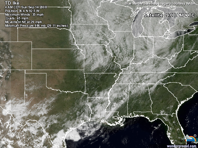 Figure 2. Latest satellite image of Ike. Ike Hurricane Ike has become a large and dangerous Cape Verdes-type hurricane much earlier than expected. With a remarkable burst of rapid intensification, Ike went from a tropical storm with 70 mph winds to a Category 4 hurricane with 135 mph winds in just 12 hours. We're lucky Ike wasn't bearing down on the Florida Keys, Tampa, or some other vulnerable populated area when this very rapid and unforecast strengthening occurred. There would have been no time to evacuate, resulting in heavy loss of life. It's situations like this that scare the bejeebers out of hurricane forecasters, and make us call for the very reasonable sums of money needed to be invested to improve hurricane intensity forecasts. We can do much better with intensity forecasts if we spend a few tens of millions per year more in such efforts. The payoff could well be the ability to foresee rapid intensification like Ike's, and prevent a major catastrophe. Visible satellite loops of Ike show the classic signatures of a major hurricane--a well-formed eye, plenty of spiral bands, and well-established upper-level outflow. However, the storm has a squashed appearance, and is missing a chunk on the northwest side. This is due to 20 knots of wind shear impacting the storm, thanks to strong upper-level winds out of the northwest. However, Ike has formed a strong eyewall, and the high angular momentum of these eyewall winds are keeping the shear from disrupting its inner core. Track forecast for Ike The models are split into two distinct camps on the 1-3 day track of Ike. The UKMET/GFS/HWRF models allow Ike go go a bit further north initially, then show less of a southerly component of motion than the other models. The other camp of models, the NOGAPS/ECMWF/GFDN/GFDL, take Ike further south, and have more of a southward component of motion, with a threat to Cuba and Hispaniola by this weekend. The NHC forecast splits the difference between these extremes, and probably has higher uncertainty than average. Climatology, as seen in the latest historical comparison of similar hurricanes in the past, favors the more northerly track. Only one out of ten similar past storms has made landfall in the U.S. as a hurricane. The longer term fate of Ike remains highly uncertain--as usual. If Ike follows the southern camp of models, it may hit eastern Cuba, as forecast by the latest (06Z, 2am EDT) runs of the NOGAPS and GFDL models. A hit on Cuba would severely disrupt the storm, weakening it to a Category 1 or 2. If Ike misses Cuba, South Florida can expect a highly dangerous major hurricane on its doorstep Tuesday. On Tuesday, a trough of low pressure is forecast by most of the models to turn Ike to the north. The timing and strength of this trough will be critical in determining the fate of South Florida. The GFS model turns Ike well east of Florida, sending the storm out to sea without affecting the U.S. The ECMWF model turns Ike directly over South Florida, while the NOGAPS model foresees recurvature just offshore, through the western Bahama Islands. It is impossible to know at this time when or if Ike will turn to the north, and whether Florida might be spared the full brunt of Ike. Ike may be a threat to North Carolina in the longer term, and one possible scenario for the hurricane would be a repeat of Hurricane Floyd of 1999. Floyd bore down on Florida as a borderline Category 4/5 hurricane before turning at the last moment, eventually hitting North Carolina as a Category 2 hurricane. Another scenario, which is suggested by the ECMWF model, is that Ike would recurve but not get pulled all the way out to sea. Instead, Ike might get trapped in a region of weak steering currents and wander for a few days, like Fay and now Gustav have done. This could occur offshore the East Coast, or over the Florida Peninsula. Intensity forecast for Ike Sea surface temperatures (SSTs) have warmed to 28.5°C and will warm an extra degree over the next two days. However, the shear is forecast to be unfavorable for intensification over the next two days, 20-30 knots. The high shear may be able to disrupt the inner core of Ike, reducing it to a Category 2 storm by Saturday morning. Re-intensification is likely beginning on Saturday night, when the shear is forecast to fall below 5 knots. On Sunday, when Ike may be approaching the southeastern Bahamas, it should encounter cooler waters stirred up by Hurricane Hanna. This may limit the re-intensification of Ike. The primary danger in the islands will be wind damage, since the storm surge typically flows around small islands. However, a Category 4 or 5 hurricane is capable of generating a maximum storm surge of 13 feet in the Turks and Caicos Islands on the right side of the eye, if it makes a direct hit on an island. The first Hurricane Hunter mission into Ike is scheduled for Friday morning. Josephine Tropical Storm Josphine is a long way out to sea, and it will be at least a week before it may threaten any land areas. Visible satellite loops show a moderately well-organized system that is having some struggles with dry air and wind shear. Elsewhere in the tropics The GFS model is forecasting that at least one more tropical wave will move off the coast of Africa over the next ten days and develop into a tropical storm. My next blog entry will be this afternoon. Jeff Masters
Tropical Storm Hanna
is becoming more organized, according to the latest satellite imagery
and data from the Hurricane Hunters. The latest center report at 3:44
pm EDT found the pressure had dropped 5 mb in just two hours, down to
990 mb. Satellite loops
show that wind shear continues to interfere with Hanna's organization,
with most of the heavy thunderstorms limited to the northeast side of
the storm. However, the amount and intensity of these thunderstorms has
increased in recent hours. Wind shear
has dropped to a moderate 15 knots over Hanna--the lowest shear the
storm has seen. The direction of the upper level winds creating this
shear has shifted from northwesterly to southwesterly today, and this
new shear direction should keep Hanna's heaviest thunderstorms on the
north side of the circulation center for the remainder of the storm's
life. The new shear direction was a welcome change for northern Haiti,
where Hanna's flooding rains have killed 26 people. Satellite estimates suggest six inches of rain has fallen on northern Haiti and the northern Dominican Republic from Hanna.
The track forecast for Hanna Hanna has finally begun its turn to the northwest, after moving farther east than most of the models expected. The next set of 18Z model runs, available tonight at about 8-9 pm EDT, should have a pretty good handle on where Hanna will make landfall, since the storm is done with its erratic movement. A landfall location near the South Carolina/North Carolina border Friday night is my forecast. On Saturday, Hanna will be racing north along the East Coast, bringing tropical storm conditions to the mid-Atlantic and New England states. The intensity forecast for Hanna The wind shear is forecast to remain in the moderate to marginal range, 15-25 knots, over the remainder of Hanna's life. There is a large amount of dry continental air lying between Hanna and South Carolina, which will continue to cause problems for the storm. However, sea surface temperatures are a warm 29°C, with a Tropical Cyclone Heat Potential (TCHP) of 40-70, just below the value of 80 typically associated with rapid intensification. The main intensity models--GFDL, HWRF, SHIPS, and LGEM--all keep Hanna as a tropical storm for the remainder of its life. However, given the large size of this storm and its proven resilience to wind shear, I give a 60% chance intensification to a Category 1 hurricane will occur. 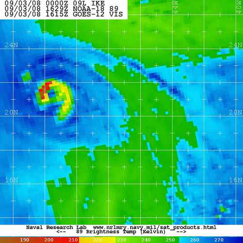 Figure 1. Microwave image of Hurricane Ike at 12:29 pm EDT 9/3/08 showing a developing eyewall that looks like the number "6". Image credit: Navy Research Lab, Monterey. Ike Tropical Storm Ike is probably a hurricane now, and has the potential to become a large and dangerous Cape Verdes-type hurricane by Sunday. Visible satellite loops show that heavy thunderstorm activity has now wrapped all the way around the core of the storm, and microwave imagery (Figure 1) shows that Ike has built an eyewall. An eye has just appeared on visible satellite imagery, as well. Upper-level outflow is good, and Ike is in a very favorable upper-level wind environment, with an upper-level anticyclone overhead, and wind shear less than 10 knots. Ike has moistened the atmosphere around it enough to wall off a large amount of dry air that surround it. Rather cool sea surface temperatures (SSTs) of 27.5°C will quickly warm to 29.5°C over the next two days, but the shear is forecast to increase to 20-35 knots Thursday through Friday. Ike will probably remain a Category 1 hurricane through Friday, then enter a period of rapid intensification to major hurricane status Saturday or Sunday, assuming that it maintains its eyewall through Thursday and Friday's shear. The GFDL model forecasts Ike will hit the Dominican Republic Saturday night as a Category 3 hurricane. The HWRF model has Ike missing Hispaniola, and plowing into the southeastern Bahamas as a Category 4 hurricane on Sunday and Monday. Northern portions of the Dominican Republic and Haiti should anticipate the possibility of heavy rains of 4-8 inches on Saturday and Sunday, even if the storm passes north of the island. I expect Ike will become a major hurricane on Saturday or Sunday. The longer term fate of Ike remains uncertain--as usual. The three long-range models (ECMWF, GFS, and NOGAPS) all forecast Ike will recurve on Tuesday. This recurvature will happen between South Florida and the central Bahama Islands, taking Ike out to sea or very near the Outer Banks of North Carolina. The timing and strength of trough of low pressure expected to turn Ike north is uncertain at this time. This will depend, in part, how strong Hanna gets, since Hanna will be interacting with this trough. Ike could turn sooner than the models predict, affecting just the Bahamas, or later than predicted, taking it through South Florida, the Florida Keys, or Cuba and into the Gulf of Mexico. The models will have a clearer picture of things by Friday, when Hanna will make its intentions known. I don't have a guess at this point which way Ike will go. Josephine Tropical Storm Josphine is a long way out to sea, and it will be at least a week before it may threaten any land areas. Elsewhere in the tropics The GFS model is forecasting that at least two more tropical waves will move off the coast of Africa over the next ten days and develop into tropical storms. My next blog entry will be Thursday morning. Jeff Masters
Tropical Storm Hanna
has weathered the worst of the wind shear affecting it, but continues
to struggle. The strong upper-level winds from the north have weakened,
and wind shear has fallen from 30 knots yesterday to 15 knots today.
There is a large amount of dry continental air to the northwest of
Hanna, and this is also interfering with the storm. Satellite loops
show that Hanna is poorly organized, with heavy thunderstorms limited
to the east side of the storm. Fortunately, these thunderstorms have
moved away from northern Haiti, where flooding rains from Hanna killed
21 people yesterday. Satellite estimates suggest Hanna has dumped up to six inches of rain on northern Haiti and the northern Dominican Republic.
The track forecast for Hanna Hanna has been moving erratically over the past day, and has moved considerably farther east than most of the models expected. This decreases the threat to the western Bahama Islands, Florida, and Georgia, since Hanna will be starting further east when it makes its expected turn to the northwest. A landfall location near the South Carolina/North Carolina border is more likely, which would occur Friday night. On Saturday, Hanna will be racing north and then northeast along the U.S. East Coast, bringing tropical storm conditions to the mid-Atlantic and New England states. The intensity forecast for Hanna The wind shear is forecast to remain at its current level, 15-25 knots, over the remainder of Hanna's life. There is a large amount of dry continental air lying between Hanna and South Carolina, which will continue to cause problems for the storm. However, sea surface temperatures are a warm 29°C, with a Tropical Cyclone Heat Potential (TCHP) of 40-70, just below the value of 80 typically associated with rapid intensification. The GFDL model intensifies Hanna to a Category 1 hurricane, but the HWRF and SHIPS model keep it a tropical storm. I expect Hanna will have top winds between 60 mph and 80 mph at landfall in North or South Carolina, making it a strong tropical storm or weak Category 1 hurricane. Ike Tropical Storm Ike continues getting organized over the middle Atlantic, and has the potential to become a large and dangerous Cape Verdes-type hurricane by Monday, when it is expected to be in the southeastern Bahama Islands. Visible satellite loops show that heavy thunderstorm activity is starting to wrap around the core of the storm, and Ike has about 50% of an eyewall built. Upper-level outflow is good, and Ike is in a very favorable upper-level wind environment, with an upper-level anticyclone overhead, and wind shear less than 10 knots. Ike has moistened the atmosphere around it enough to wall off a large amount of dry air that surrounds it. Rather cool sea surface temperatures (SSTs) of 27.5°C. SSTs will quickly warm to 29°C over the next two days, but the shear is forecast to increase to 20-35 knots Thursday through Friday. The SHIPS model responds by strengthening Ike only to a Category 1 hurricane today, then weakening it to a tropical storm during the higher shear, then strengthening it again to a Category 1 hurricane by Saturday. The HWRF and GFDL models do not predict the shear will affect Ike as much Thursday and Friday, and intensify the storm into a Category 2 or higher hurricane by Sunday. The HWRF makes Ike a Category 4 hurricane in the eastern Bahama Islands on Monday, and the GFDL has Ike hitting eastern Cuba as a Category 2 or 3 hurricane on Monday. I expect Ike to be a hurricane by Thursday morning, and a Category 3 or higher hurricane by Monday. The longer term fate of Ike is highly uncertain. The ECMWF and GFS models both forecast that Hanna will be strong enough to create a weakness in the ridge of high pressure steering Ike to the west. Ike will then follow Hanna's path, recurving northwards. the timing of this recurvature is critical, as the GFS shows that Ike will miss the U.S., while the ECMWF forecasts a strike in South Florida on Tuesday, then another landfall in North Carolina later in the week. If Hanna is not as strong or is faster-moving than these models expect, Ike may not recurve. Instead, Ike will cross Cuba or move through the Florida Straits, eventually emerging into the Gulf of Mexico to cause havoc there. This is my current expectation. Josephine Tropical Storm Josphine is a long way out to sea, and it will be at least a week before it may threaten any land areas. Elsewhere in the tropics The GFS model is forecasting that at least two or three more tropical waves will move off the coast of Africa over the next ten days and develop into tropical storms. The NOGAPS model is predicting possible development near the Yucatan Peninsula 4-6 days from now, either in the western Caribbean or the Gulf of Mexico's Bay of Campeche. Gustav's march of destruction through the Caribbean A brief summary of Gustav's path: Haiti Gustav hit Haiti as a category 1 hurricane, dropping up to a foot of rain on that country's southern peninsula. On 31 August, official government figures reported 76 deaths and four people missing, 8,789 people in emergency shelters, 2,121 houses destroyed, and 8,155 houses damaged. Numbers are likely to rise. With hurricane season less than half over and Hurricane Ike expected to pass close by, the misery for Haiti may only be beginning. Dominican Republic Damage was limited in the Dominican Republic, but a rain-triggered landslide killed eight people. Jamaica In Jamaica, Gustav killed 12 people and did at least $110 million in damage to roads and bridges. The banana crop was hit hard, and there was extensive damage to the power and water infrastructure. The tourist industry was relatively unaffected. Cayman Islands Gustav passed 25 miles south-southwest of Little Cayman Island at 10 pm on Friday, as a strengthening Category 1 hurricane. Almost every building on the island suffered roof damage, and every dock on the island was destroyed or severely damaged, according to caycompass.com. Nearby Cayman Brac Island was less severely affected, and Grand Cayman island was not seriously affected. Cuba Cuba took bad beating, but Gustav just missed hitting the capital city of Havana. Damage is likely to be in the hundreds of millions, and not in the billions, as originally feared. No one died in the storm. Gustav destroyed 2,000 buildings and damaged 150,000. Power was lost over the entire western end of the island, including the 2.2 million residents of Havana. Gustav's eye passed over the Isle of Youth, where 87% of all the homes were damaged or destroyed. Officials measured gusts of 212 mph (340 kph) in the western town of Paso Real del San Diego, a new national record for maximum wind speed, according to the Cuban Institute of Meteorology. Figure 1. Radar estimated rainfall from Gustav The U.S. Gustav killed nine people in the U.S., Eqecat Inc., predicts insured losses will be between $3 billion and $7 billion. AIR Worldwide projects a lower number, $1.8-$4.4 billion. Using the usual rule of thumb that total losses are double insured losses, Gustav's price tag will be in the $4-$14 billion range, ranking it between 19th and 5th place on the list of costliest U.S. hurricanes. Louisiana took the brunt of the wind damage, particularly in the coastal areas west of New Orleans where the eye came ashore. Flooding from heavy rains in excess of 15 inches (Figure 1) is also responsible for significant damage in Louisiana, and a damaging storm surge of 10-12 feet affected the New Orleans region. Losses were in the tens of millions along the coast of Misssissippi, where the storm surge ranged from 11 feet in Waveland at the Louisiana border to 6.5 feet at the eastern end of the coast. The small community of Pearlington, nearest the Louisiana line in Hancock County, reported a 19-foot surge that flooded around 100 homes, according to the Mississippi Emergency Management Agency. Wind damage in Mississippi was light, since sustained winds reached only 40 mph. Damage to the offshore oil and gas facilities in the Gulf of Mexico was about $1-$3 billion. Hearty congratulations go to the people and officials in New Orleans, who staged a very successful evacuation. Congratulations also go to the Army Corps of Engineers, whose improvements to the levee system held against storm surges similar to what Katrina brought. When hurricanes collide I'm getting this question a lot--can hurricane collide to form a super hurricane? No, hurricanes cannot collide to make a bigger hurricane. When hurricanes get within about 900 miles of each, they begin to interact. There are three possible outcomes: 1) The larger storm will destroy the smaller one. The larger storm's upper-level outflow will bring hostile wind shear over the smaller storm, and the larger storm may steal the smaller storm's moisture. This occurred in 2005, when Hurricane Wilma destroyed Tropical Storm Alpha over Hispaniola. 2) Both hurricanes will compete for the same energy, resulting in weakening of both storms. 3) The storms will rotate around a common center of rotation (the Fujiwhara Effect), before going on their separate ways. Hurricane Humberto and Hurricane Iris took part in a brief Fujiwara interaction in 1995. Iris then began interacting with a third storm, Tropical Storm Karen, which orbited and later merged with the more intense Iris. Sometimes, a recurving hurricane will leave behind an enhanced trough of low pressure that will act to help recurve the storm behind it along the same path. This is possible this week with Ike and Hanna. More info coming this afternoon at the usual time. Jeff Masters
With four named storms going at once--Gustav, Hanna, Ike, and
Josephine--the tropics are exceptionally active today. The last time
there were four named systems present on the same day was on August 24,
1999,
when Bret, Cindy, Dennis and Emily were all active in the Atlantic.
Four hurricanes have occurred simultaneously on two occasions. The
first occasion was August 22, 1893. The second time was on September 25-27, 1998, when Georges, Ivan, Jeanne and Karl were all hurricanes. There have been five named storms at once--this occurred in 1971, from September 10 to 12.
Hanna Hanna has weathered the worst of the wind shear that has been affecting it, and is holding its own. The strong upper-level winds from the north have weakened, allowing the wind shear to fall from 30 to 25 knots this afternoon. Satellite loops show that Hanna has responded by building a little more heavy thunderstorms near its center, although these thunderstorms are still absent on the northwest side of the storm. The track forecast for Hanna The current steering flow driving Hanna to the southeast is very weak, and we can expect erratic motion over the next day. By Wednesday, a rather strong high pressure ridge will build over Hanna, forcing it northwest to a landfall in the Southeast U.S. Due to the storm's expected rather random motion over the next day, plus the expected track of Hanna parallel to the Southeast U.S. coast, the location of final landfall has a much higher uncertainty than usual. South Carolina would be the best bet, since it sticks out further than northern Florida and Georgia. The intensity forecast for Hanna The wind shear is forecast to gradually relax to 10-15 knots by Wednesday morning, and remain in the 10-20 knot range until landfall Friday. This reduced shear should allow Hanna to intensify, as the storm will be over warm 29°C waters with a Tropical Cyclone Heat Potential (TCHP) of 50-70, just below the value of 80 typically associated with rapid intensification. The GFDL, HWRF, and SHIPS models all respond by intensifying Hanna to a Category 1 hurricane by landfall in the Southeast U.S., which is a reasonable forecast. Ike Tropical Storm Ike continues getting organized over the middle Atlantic, and has the potential to become a large and dangerous Cape Verdes-type hurricane by Sunday. Visible satellite loops show a large and expanding circulation, with good upper-level outflow developing in all quadrants. Ike is in a very favorable upper-level wind environment, with an upper-level anticyclone overhead, and wind shear less than 10 knots. Heavy thunderstorm activity has increased significantly today, as Ike has moistened the atmosphere around it to wall off dry air that was interfering with its organization. Rather cool sea surface temperatures (SSTs) of 27.5°C. SSTs will gradually warm to 29°C over the next four days, but the shear is forecast to increase above 20 knots by Thursday. The SHIPS model responds by strengthening Ike only to a Category 1 hurricane tomorrow, then weakening it to a tropical storm during the higher shear, then strengthening it again to a Category 1 hurricane by Sunday. The HWRF and GFDL models do not predict the shear will affect Ike as much 3-4 days from now, and intensify the storm into a Category 2 or higher hurricane by Saturday, when it is expected to be entering the eastern Bahama Islands. These models no longer predict landfall in the Dominican Republic or Haiti. The longer term fate of Ike is highly uncertain. The ECMWF model forecasts that Hanna will be strong enough to create a weakness in the ridge of high pressure steering Ike to the west. Ike will then follow Hanna's path, recurving northwards off the Florida coast, with a pass very close to North Carolina and New England. The NOGAPS model thinks Hanna will not influence Ike as much, and Ike will hit South Florida. The GFS model is no help, it dissipates Ike in the Bahamas. A track across Cuba and into the Gulf of Mexico or the Western Caribbean is also a strong possibility. We'll have to see how strong Hanna gets before the future path of Ike will be apparent. Josephine Tropical Storm Josephine is looking pretty impressive for a tropical storm that just formed today. However, it's currently looking like Josephine may not trouble any land areas, and I'm going to give it short shrift today and move on. Elsewhere in the tropics There's a tropical wave over Africa behind Josephine that the GFS model forecasts will develop into a tropical storm next week. My next blog entry will be Wednesday morning, and I'll have a summary of the devastation Gustav wrought along its path. Jeff Masters
Tropical Depression Gustav
has moved inland over western Louisiana, and is now primarily a heavy
rain threat. The rainfall forecast from NOAA's Hydrological Prediction
Center (Figure 1) for the next five days foresees up to eight inches of
rain over Louisiana, Arkansas, Missouri, and Illinois, which may cause
some moderate flooding problems. Tornadoes are also a threat today;
Gustav spawned 17 tornadoes yesterday.
Gustav generated a storm surge of 10-13 feet on the east side of New Orleans. This is characteristic of a strong Category 1 hurricane, and is similar to the surge Katrina generated along the New Orleans levee system. New Orleans was spared a full Category 2 storm surge, since Gustav hit too far to the west. According to NHC's (now retired) storm surge expert Dr. Stephen Baig, a full Category 2 storm surge would have been ~6 ft at the Lakefront, ~7.5 ft on the North Shore of Lake Pontchartrain, >9 ft in Plaquemines , >8 ft in St. Bernard, ~13 ft at Waveland, and ~8 ft at Grand Isle. NOAA tide gauges recorded maximum surges of 4.5 ft at Grand Isle and 10 ft at Waveland. AIR Worldwide Corporation is estimating that Gustav's damage will be $1.8-$4.4 billion dollars. 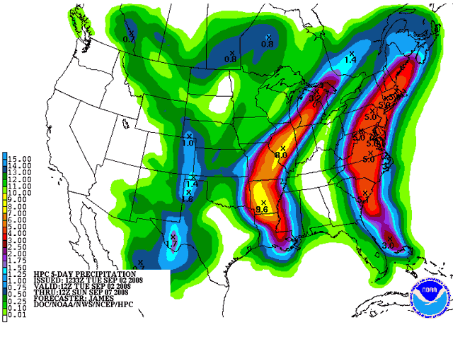 Figure 1. Predicted rainfall from Gustav and Hanna over the next five days. Image credit: NOAA/HPC. Comparing Gustav to Katrina We got very lucky with Gustav--it could have been another Katrina. Both Gustav and Katrina had similar diameters (not radii) of tropical storm force winds at landfall--440 miles. However, Katrina affected the coast with a region of hurricane force winds 170 miles across--45% larger than the 115 miles of coast affected by Gustav (Figure 2). Both storms passed over some very high heat content waters in the Gulf of Mexico--Katrina, over a Loop Current eddy, and Gustav, over the Loop Current itself. Why didn't Gustav explode into a Cat 5 monster storm when it crossed the Loop Current yesterday? Well, when a hurricane has a well-formed circular eyewall that is aligned vertically from the surface to the upper atmosphere, it acts as a very efficient heat engine that can take heat out of the ocean and convert it to the kinetic energy of its winds. When Katrina hit its Loop Current eddy, the hurricane was under low wind shear and had an ideal structure like this for taking advantage of the heat energy offered to it. Gustav, on the other hand, had just crossed Cuba when it hit the Loop Current. Gustav was under about 15 knots of wind shear, which it had been able to hold off, thanks to its tight, well-formed eyewall. However, passage over Cuba disrupted the eyewall structure just enough to allow the upper-level winds shearing it to penetrate into the heart of the hurricane. These winds ripped up the eyewall and tilted it, so that the surface eye was no longer underneath the upper-atmosphere eye. A tilted eyewall structure is not able to act as an efficient heat engine until it can get itself lined up more vertically, so Gustav was unable to take advantage of the warm Loop Current waters it was traversing. It's like when your car engine is not firing on all cylinders and you hit the gas pedal--nothing happens. Once Gustav finally did align its eyewall vertically and armored itself against the effects of the wind shear, it had passed beyond the Loop Current and was over cooler waters of much lower heat content. Thus, Gustav was not able to intensify much before landfall. The computer models that predicted a Category 4 hurricane at landfall could easily have been correct, had the shear been a few knots less when Gustav crossed Cuba.  Figure 2. Comparison of the sizes of Hurricane Gustav and Hurricane Katrina shortly before landfall. The outermost black heavy line denotes the 34 knot radius of tropical storm force winds, while the black heavy line marking the beginning of orange colors (64 knots) denotes the region of hurricane force winds. Both Gustav and Katrina had similar diameters (not radii) of tropical storm force winds at landfall--440 miles. However, Katrina affected the coast with a region of hurricane force winds 170 miles across--45% larger than the 115 miles of coast affected by Gustav. Image credit: NOAA/AOML/HRD. Hanna Hanna is struggling with some extremely high wind shear of 30 knots, thanks to strong upper-level winds from the north. It's amazing that the storm has held together in the face of this shear, but Hanna is definitely suffering. Satellite loops show the shear has destroyed all of Hanna's heavy thunderstorm activity except on the south side. These heavy thunderstorms are currently pummeling Haiti. The track forecast for Hanna The current steering flow driving Hanna to the west-southwest is very weak, and we can expect erratic motion over the next day. By Wednesday, a rather strong high pressure ridge will build over Hanna, forcing it northwest to a landfall in the Southeast U.S. Due to the storm's expected rather random motion over the next day, plus the expected track of Hanna parallel to the Southeast U.S. coast, the location of final landfall has a much higher uncertainty than usual. The intensity forecast for Hanna The wind shear of 30 knots is forecast to gradually relax to 10-15 knots by tomorrow morning, and remain in the 10-20 knot range until landfall Friday. This reduced shear should allow Hanna to intensify, as the storm will be over warm 29°C waters with a Tropical Cyclone Heat Potential (TCHP) of 50-70, just below the value of 80 typically associated with rapid intensification. The GFDL and HWRF models respond by intensifying Hanna to a Category 2 hurricane by landfall; the SHIPS model foresees a Category 1 hurricane. However, these models did not anticipate Hanna's current disorganization. Given the current disorganized state of Hanna, Category 1 strength is probably the maximum the storm has time to achieve before landfall. Ike Tropical Storm Ike spun up yesterday in the middle Atlantic, and has the potential to become a major Cape Verdes-type hurricane. Visible satellite loops show an expanding circulation, with good upper-level outflow developing in all quadrants. Ike is in a very favorable upper-level wind environment, with an upper-level anticyclone overhead, and wind shear less than 10 knots. There is not much heavy thunderstorm activity yet, probably due to the presence of some dry air and rather cool sea surface temperatures (SSTs) of 27°C. SSTs will gradually warm to 29°C over the next five days, but the shear is forecast by some models to increase above 20 knots by Thursday. The SHIPS model responds by strengthening Ike only to a Category 1 hurricane. However, the HWRF and GFDL models do not depict as much shear 3-5 days from now, and intensify Ike into a major Category 3 or 4 hurricane on Friday, when it is expected to be 100-300 miles north of Puerto Rico. Both of these models predict landfall in the Dominican Republic or Haiti as a major hurricane on Saturday. This kind of intensification seems unlikely at present, due to the increased shear likely Thursday and Friday. The GFS and ECMWF foresee Ike passing through Cuba and into the Gulf of Mexico next week. The first Hurricane Hunter mission into Ike is scheduled for Friday afternoon. Josephine Tropical Storm Josphine formed today off the coast of Africa, just like the long-range GFS model has been predicting for the past week. The GFS has done very well forecasting up to a week in advance the recent string of African tropical waves that have developed. Josephine looks like it could be a problem for the Northern Lesser Antilles Islands a week or so from now, but it is too early to be confident of this. The tropics are too busy to spend much time on Josephine. I'll say more on it later this week. Elsewhere in the tropics There's a tropical wave over Africa behind Josephine that the GFS model forecasts will develop into a tropical storm next week. My next blog entry will be this afternoon. There will be a new Hurricane Hunter plane in Hanna to report on. Jeff Masters
Hurricane Gustav
continues plowing inland, and is now just a Category 1 hurricane. The
storm surge has peaked and is falling in New Orleans and along the
Mississippi coast. A storm surge of 12 feet was recorded at Northeast
Bay Gardene, and surges of 10 feet were seen at several other locations
(Figure 2). Higher storm surges no doubt affected nearby locations, and
some levees were overtopped. However, there are no reports as yet that
any levees failed.
Top winds I've seen measured at the surface in Gustav were at the mouth of the Mississippi River at Pilot's Station East, which reported sustained winds of 91 mph, gusting to 117, at a height of 24 meters at 4 am CDT. Top waves were 34 feet at 2 am at Buoy 42040, south of Dauphin Island, Alabama. Gustav has spawned seven tornadoes so far. No serious damage has been reported from these twisters yet.  Figure 1. Hurricane Gustav at landfall, 10:40 am EDT 9/1/08. At the time, Gustav was a Category 2 hurricane with 110 mph winds. A strengthening Tropical Storm Hanna is visible at right. Image credit: NASA. 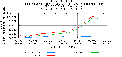 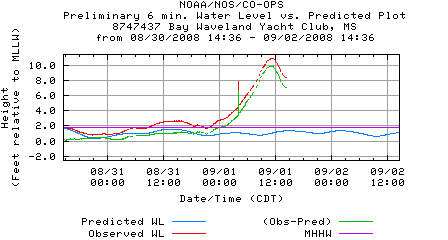 Figure 2. The tide gauge at Shell Beach (top), on the east side of New Orleans in Lake Borgne, recorded a peak storm surge 9.5 feet at about noon today. The storm surge peaked at 10 feet in Waveland, Mississippi (bottom). Image credit: NOAA Tides & Currents. Now that the storm surge has died down, the main concerns from Gustav are wind damage and fresh water flooding. NOAA is predicting up to 16 inches of rain could fall in the next five days over Louisiana (Figure 3). So far, up to six inches of rain has fallen in coastal Louisiana.  Figure 3. Predicted rainfall from Gustav and Hanna over the next five days. Image credit: NOAA/HPC. Comparing Gustav to Katrina We got very lucky with Gustav--it could have been another Katrina. Both Gustav and Katrina had similar diameters (not radii) of tropical storm force winds at landfall--440 miles. However, Katrina affected the coast with a region of hurricane force winds 170 miles across--45% larger than the 115 miles of coast affected by Gustav (Figure 4). Both storms passed over some very high heat content waters in the Gulf of Mexico--Katrina, over a Loop Current eddy, and Gustav, over the Loop Current itself. Why didn't Gustav explode into a Cat 5 monster storm when it crossed the Loop Current yesterday? Well, when a hurricane has a well-formed circular eyewall that is aligned vertically from the surface to the upper atmosphere, it acts as a very efficient heat engine that can take heat out of the ocean and convert it to the kinetic energy of its winds. When Katrina hit its Loop Current eddy, the hurricane was under low wind shear and had an ideal structure like this for taking advantage of the heat energy offered to it. Gustav, on the other hand, had just crossed Cuba when it hit the Loop Current. Gustav was under about 15 knots of wind shear, which it had been able to hold off, thanks to its tight, well-formed eyewall. However, passage over Cuba disrupted the eyewall structure just enough to allow the upper-level winds shearing it to penetrate into the heart of the hurricane. These winds ripped up the eyewall and tilted it, so that the surface eye was no longer underneath the upper-atmosphere eye. A tilted eyewall structure is not able to act as an efficient heat engine until it can get itself lined up more vertically, so Gustav was unable to take advantage of the warm Loop Current waters it was traversing. It's like when your car engine is not firing on all cylinders and you hit the gas pedal--nothing happens. Once Gustav finally did align its eyewall vertically and armored itself against the effects of the wind shear, it had passed beyond the Loop Current and was over cooler waters of much lower heat content. Thus, Gustav was not able to intensify much before landfall. The computer models that predicted a Category 4 hurricane at landfall could easily have been correct, had the shear been a few knots less when Gustav crossed Cuba. Figure 4. Comparison of the sizes of Hurricane Gustav and Hurricane Katrina shortly before landfall. The outermost black heavy line denotes the 34 knot radius of tropical storm force winds, while the black heavy line marking the beginning of orange colors (64 knots) denotes the region of hurricane force winds. Both Gustav and Katrina had similar diameters (not radii) of tropical storm force winds at landfall--440 miles. However, Katrina affected the coast with a region of hurricane force winds 170 miles across--45% larger than the 115 miles of coast affected by Gustav. Image credit: NOAA/AOML/HRD. Hurricane Hanna Looking at the satellite loops and wind shear images of Hanna, you'd never suspect that this storm was a hurricane. Hanna is under very high wind shear of 25 knots, thanks to strong northerly upper-level winds that are part of the outflow from Hurricane Gustav. These strong winds have distorted Hanna into an amorphous shifting blob of heavy thunderstorms with little resemblance to a hurricane. Nevertheless, it is a hurricane--the Hurricane Hunters found a central pressure of 983 mb at 3:16 pm EDT this afternoon, with surface winds of 75 mph. However, the shear is so strong that Hanna has not been able to form an eyewall. Recent eye reports from the Hurricane Hunters suggest this process is underway, though. The track forecast for Hanna The current steering flow driving Hanna to the west-southwest is very weak, and we can expect erratic motion or a loop over the next two days, in the vicinity of the Bahama Islands. Hanna may move far enough south to hit Cuba, which would seriously weaken the storm. However, only the UKMET model forecasts this, and I'm not counting on Cuba helping the U.S. out again. By Wednesday, a rather strong high pressure ridge will build over Hanna, forcing it to a landfall in the Southeast U.S. Due to the storm's expected rather random motion over the next two days, the location of final landfall has a much higher uncertainty than usual. It is cases like this that really expand the size of NHC's cone of uncertainty, when they go to recalculate the size the cone after hurricane season. So, take your pick of landfall locations: UKMET, South Florida, Thursday night GFS, GA/SC border, Friday afternoon NOGAPS, FL/GA border, Friday morning GFDL, GA/SC border, Friday morning, Category 3 HWRF, GA, Friday morning, Category 2 ECMWF, GA/SC Friday These landfall locations have been shifting around quite a bit over the past few days, with North Carolina the favored target yesterday. There have yet to be any model runs showing Hanna recurving out to sea without hitting the U.S. It is likely that Hanna will recurve after landfall, dumping copius amounts of rain on the mid-Atlantic states and New England. The intensity forecast for Hanna OK, here are my words from yesterday: "Hanna will not be able to intensify significantly over the next two days, due to upper low it is situated under, and the outflow from Hurricane Gustav." Well, the upper low dissipated, which apparently was enough to allow Hanna to intensify, despite 25 knots of wind shear. It's very unusual to see a tropical storm intensify into a hurricane while under that much wind shear. The shear is expected to remain 20-30 knots over the next 1-2 days, then decrease to 10 knots by Friday as Gustav weakens and pulls away, reducing the amount of its upper-level outflow that is currently shearing Hanna so much. All the major intensity models respond by intensifying Hanna into a Category 2 or stronger hurricane. This is a low confidence intensity forecast--as is typical for intensity forecasts. I wouldn't be surprised if Hanna drops back down to tropical storm strength Tuesday or Wednesday, due to the shear. As is the case with the track forecast, we don't have a very good idea how strong Hanna might be on Thursday and Friday. Here come Ike and Josphine! OK, this is really getting nuts. We've got two more very impressive storms that came off the coast of Africa that look like they will become hurricanes. Ike has a good chance of becoming a large and dangerous major Cape Verdes-type hurricane, although our skill in predicting such things five days in advance is nil. The GFDL model makes Ike a Category 2 hurricane by Thursday, while the HWRF forecasts a Cat 4. NHC conservatively forecasts a Cat 1. Visible satellite loops show a large and very intimidating circulation, with plenty of heavy thunderstorm activity and decent upper-level outflow beginning. Ike is expected to pass well north of the Lesser Antilles Islands on Friday or Saturday, but will get forced west-southwest towards Hispaniola or the Bahamas late this week. I do not expect Ike to recurve out to sea. Ike's sister, Josephine (AKA 99L), looks like it will form just off the coast of Africa on Tuesday. Elsewhere in the tropics There are two other areas of disturbed weather in the Atlantic that currently don't appear to be threats to develop, due to high wind shear. NHC is giving these systems a low (<20% chance) of developing into a tropical depressions over the next two days. Consult the NHC Graphical Tropical Weather Outlook for more details. There is one other impressive African tropical wave lined up behind 99L that is likely to be a threat to develop once it moves offshore Africa late this week. It's time for a vacation in the ice-free Arctic this September! Yes, the Arctic now has it's second lowest ice extent on record, and may surpass the record set just last year. The Northwest Passage has opened up for the second time in recorded history, 2007 being the other time. I'll blog about this in more detail once the unbelievable onslaught of hurricanes eases up. My next blog entry will be Tuesday morning. Jeff Masters
Hurricane Gustav
is making landfall on the Louisiana coast just southwest of New Orleans
as a powerful Category 2 hurricane. Latest data from the Hurricane
Hunters at 8:30 am EDT shows that Gustav continues to weaken, with the
pressure now 957 mb, and no surface winds above Category 2 strength
observed. Cold water that the hurricane stirred up from the depths plus
the effects of wind shear caused the eyewall to collapse a few hours
before landfall, resulting in weakening. However, the hurricane reacted
to collapse of the eyewall by broadening its wind field, spreading out
the strongest winds over a wider area. The diameter of coastline being
subjected to tropical storm force winds is now 440 miles, the same as
Katrina. Hurricane force winds will be felt by a 115 mile-wide stretch
of coast (Katrina's reach was 205 miles). Gustav remains a huge and
powerful storm whose winds and storm surge will cause a tremendous
amount of damage as the storm blasts through Louisiana today.
Figure 1. The tide gauge at Shell Beach, on the east side of New Orleans in Lake Borgne, recorded a storm surge over 7 feet as of 8 am EDT today. Image credit: NOAA Tides & Currents. The main concern from Gustav is the storm surge. NHC is still predicting a 10-14 foot storm surge along the east side of New Orleans (Figure 2). This storm surge is characteristic of a Category 3 hurricane, providing a significant test of New Orleans' rebuilt levee system. Recent tide gauge readings from the east side of New Orleans show that a storm surge in excess of 7 feet has already occurred in Lake Borgne (Figure 1). The satellite appearance of Gustav is slowly degrading. Visible satellite loops show Gustav has no eye, but still has an impressive amount of heavy thunderstorms. New Orleans radar shows some very heavy rain occurring in spiral bands rotating ashore, and several rotating tornadic thunderstorms have developed in these bands this morning, triggering tornado warnings. No confirmed tornadoes have been reported yet. Top winds measured at the surface were at the mouth of the Mississippi River at Pilot's Station East, which reported sustained winds of 91 mph, gusting to 117, at a height of 24 meters at 4 am CDT.  Figure 2. Predicted storm surge from NHC's experimental storm surge model. From wunderground user NOLACANEWATCHER at 8 am EDT today: I just wanted to let y'all know amazingly I still have power. My anemometer is clocking winds of 82.45 mph and my pressure is at 964mb. A gigantic branch has hit the corner of my house and there is massive damage to that area of the roof. I'll have a full update on Gustav and Hanna this afternoon. Hanna is expected to hit the U.S. East Coast on Thursday or Friday this week. New Orleans radar New Orleans weather Wunderground Tornado page Jeff Masters
|

About JeffMasters:
My Local Weather:
Recent Photos:
Previous Entries for 2008:
Recommended Links:
|


Please Visit Our Sponsors:


Ann ArborCondos and Vacations
Ann Arbor Tickets and Technology
Real Estate Guide
Hot Travel Savings
Advice on Surgery...
Tickets and Worldwide Attractions
College Students
Find the Weather for any City, State or ZIP Code, or Airport Code or Country:
Custom Weather Services
In addition to this website, we provide a number of free and professional weather services.
Advertise On This Site
Weather Underground has extensive targeting capabilities to fulfill all of your client's advertising needs.
| About Us - Contact - Support - Employment - Press Releases - Terms of Service - Privacy Policy - WU Gear | : Top of Page : |
Copyright © 2008 Weather Underground, Inc.
|
Copyright © 2008 Weather Underground, Inc.
|